
Evans, Lewis

Lewis Evans (1700 - June 11, 1756) was a Welsh born American naturalist, surveyor, and geographer active in Philadelphia and the Ohio Valley in the first half of the 18th century. He was born in Llangwnadl, Carnarvonshire, Wales - a fact which he revealed in his will. Otherwise, little is known of his early life. He had a classical education in England and from his own writings it is hinted that he traveled extensively abroad, as far as India and South America, before settling in Philadelphia. The first mention of Evans is his purchase of Edward Cocker's Arithmetick at Benjamin Franklin's Philadelphia bookshop on November 27, 1736, so he must have immigrated to the colonies sometime before this. From the earliest available records, it is evident he trucked elite intellectual circles, befriending, and even working with Benjamin Franklin, Cadwallader Colden (1688 - 1776), Thomas Pownall (1722 - 1805), Thomas Penn (1702 - 1775), among many others. He lectured throughout Pennsylvania on the wonders of electricity, of which he reportedly had a firm grasp. His cartographic corpus is small but significant. Other than several minor survey maps focusing on holdings in eastern Pennsylvania, Evans's published only two major maps, A Map of Pennsylvania, New Jersey, New York, and the Three Delaware Counties (1752) and A General Map of the Middle British Colonies in America (1755), the latter being a most significant and a landmark production focusing on Trans-Appalachia. It is noteworthy that Evans was a meticulous cartographer and, unlike most mapmakers of this period, based his maps an actual survey work which he personally conducted. Evans died in Philadelphia on June 11, 1756, one year after his greatest work was published. His body lies in the Christ Church Burial Ground in Philadelphia. After his death, his only daughter Amelia was brought up by Deborah and Benjamin Franklin.
Best 18th century map of the Ohio River Valley.
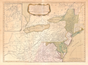
A New and General Map of the Middle Dominions Belonging to the United States of America, viz. Virginia, Maryland, the Delaware-Counties, Pennsylvania, New Jersey etc…
$1,850.00
Acquire
- Digital Map Information
- Suitable for large format printing
- DPI: 600
- File Size: 27.56 MB
- File Type: ZIP / TIFF
- ICC color profile embedded
- Delivered instantly via download link
This is the Laurie and Whittle 1794 updated edition of Lewis Evans' foundational 1755 map of the middle part of the British Colonies in North America. Evans' map was the earliest to accurately detail the American frontier at the time of its original publication. It exhibits superb detail in the northern Appalachian Mountains and the Ohio River Valley, providing information about Native American tribes and transport, French and English forts, and other details pertinent to the frontiersman, including sources of salt, roads, and trails. It was hailed by Schwartz and Ehrenberg as 'the most ambitious performance of its kind undertaken in America up to that time.' So widely was the excellence of Evans' map recognized that he was unable to make any money on it at all, as it was promptly pirated by Jefferys, Sayer, Kitchen, Bowles, Crevecoeur, and, as here, Laurie and Whittle. This 1794 edition, at least, updates the map to indicate the outcome of the American Revolution - it names the United States and includes the boundary line between the United States and Canada as determined by the 1783 Treaty of Paris. This is also the first edition of the Evans map to include the new state of Kentucky - although erroneously positioned north of the Ohio River. (more details)
Piracy of a seminal map detailing Trans-Appalachia.
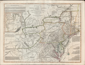
Bowles's New Pocket Map of the Middle British Colonies, in America, Vis. Virginia, Maryland, Delaware, Pensylvaia, New Jersey, New York, Connecticut and RHode Island. Comprending also the Habitations and Hunting Countries of the Confederate Indians: by Lewis Evans.
$6,500.00
Acquire
- Digital Map Information
- Suitable for large format printing
- DPI: 600
- File Size: 659.83 MB
- File Type: ZIP / TIFF
- ICC color profile embedded
- Delivered instantly via download link
A fine example of the 1780 Carington Bowles edition of the Lewis Evans map of the Middle British Colonies - one of the most important maps to emerge out of the French and Indian War (1754 - 1763). Essentially a piracy of a piracy, this is the Carington Bowles 1780 piracy of the 1771 Kitchen/Jefferys piracy of the 1755 Lewis Evans map - here given new relevance in the context of the American Revolutionary War (1775 - 1783). There are numerous subtle changes over earlier editions although the essential Lewis Evans chart - the finest and most comprehensive treatment of the Trans-Appalachia and the Ohio Valley from the French and Indian War through the Revolutionary period - remains the core. Pre-release editions of this map were circulated among British officers, including Major-General Edward Braddock (1695 - 1755), who consulted them during his disastrous 1755 expedition against the French-occupied Ohio River Valley (he was killed in the effort - but not for lack of cartographic reconnaissance). (more details)
Updating the Evans Map: First Map with Louisville
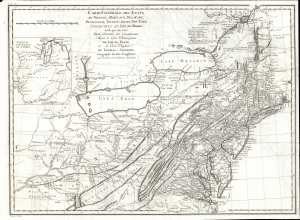
Carte Generale des Etats de Virginie, Maryland, Delaware, Pensilvanie, Nouveau-Jersey, New-York, Connecticut et Isle de Rhodes Ainsi que des Lacs Erie, Ontario, et Champlain. D'Apres la Carte Ameriquaine de Louis Evans et la Carte Anglaise de Thomas-Jefferys, pour les Lettres d'un Cultivateur Amériquain.
$1,950.00
Acquire
- Digital Map Information
- Suitable for large format printing
- DPI: 600
- File Size: 68.46 MB
- File Type: ZIP / TIFF
- ICC color profile embedded
- Delivered instantly via download link
An elegant 1787 French edition of Louis Evans' seminal and influential map of the Middle British Colonies, one of the most important maps of the British colonies and the best colonial mapping of the Ohio River Valley. It was issued for Michel Guillaume St. Jean de Crevecoeur's 1787 Lettres d'un Cultivateur Ameriquain, one of the most influential works on colonial America. (more details)