1755 / 1794 Lewis Evans Map of the Ohio River Valley / Mid-Atlantic States
MiddleStates-lauriewhittle-1794$1,850.00

Title
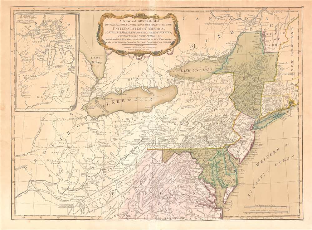
A New and General Map of the Middle Dominions Belonging to the United States of America, viz. Virginia, Maryland, the Delaware-Counties, Pennsylvania, New Jersey etc…
1794 (dated) 19 x 26 in (48.26 x 66.04 cm) 1 : 2300000
1794 (dated) 19 x 26 in (48.26 x 66.04 cm) 1 : 2300000
Description
This is the Laurie and Whittle 1794 updated edition of Lewis Evans' foundational 1755 map of the middle part of the British Colonies in North America. Evans' map was the earliest to accurately detail the American frontier at the time of its original publication. It exhibits superb detail in the northern Appalachian Mountains and the Ohio River Valley, providing information about Native American tribes and transport, French and English forts, and other details pertinent to the frontiersman, including sources of salt, roads, and trails. It was hailed by Schwartz and Ehrenberg as 'the most ambitious performance of its kind undertaken in America up to that time.' So widely was the excellence of Evans' map recognized that he was unable to make any money on it at all, as it was promptly pirated by Jefferys, Sayer, Kitchen, Bowles, Crevecoeur, and, as here, Laurie and Whittle. This 1794 edition, at least, updates the map to indicate the outcome of the American Revolution - it names the United States and includes the boundary line between the United States and Canada as determined by the 1783 Treaty of Paris. This is also the first edition of the Evans map to include the new state of Kentucky - although erroneously positioned north of the Ohio River.
Publication History and Census
This edition of the Evans map - the only one to include post-Revolutionary War detail - was engraved in 1794 by London publishers Laurie and Whittle. It appeared in editions of Thomas Kitchin's New Universal Atlas. The atlas, and separate examples of the map, are well represented in institutional collections.CartographerS
Lewis Evans (1700 - June 11, 1756) was a Welsh born American naturalist, surveyor, and geographer active in Philadelphia and the Ohio Valley in the first half of the 18th century. He was born in Llangwnadl, Carnarvonshire, Wales - a fact which he revealed in his will. Otherwise, little is known of his early life. He had a classical education in England and from his own writings it is hinted that he traveled extensively abroad, as far as India and South America, before settling in Philadelphia. The first mention of Evans is his purchase of Edward Cocker's Arithmetick at Benjamin Franklin's Philadelphia bookshop on November 27, 1736, so he must have immigrated to the colonies sometime before this. From the earliest available records, it is evident he trucked elite intellectual circles, befriending, and even working with Benjamin Franklin, Cadwallader Colden (1688 - 1776), Thomas Pownall (1722 - 1805), Thomas Penn (1702 - 1775), among many others. He lectured throughout Pennsylvania on the wonders of electricity, of which he reportedly had a firm grasp. His cartographic corpus is small but significant. Other than several minor survey maps focusing on holdings in eastern Pennsylvania, Evans's published only two major maps, A Map of Pennsylvania, New Jersey, New York, and the Three Delaware Counties (1752) and A General Map of the Middle British Colonies in America (1755), the latter being a most significant and a landmark production focusing on Trans-Appalachia. It is noteworthy that Evans was a meticulous cartographer and, unlike most mapmakers of this period, based his maps an actual survey work which he personally conducted. Evans died in Philadelphia on June 11, 1756, one year after his greatest work was published. His body lies in the Christ Church Burial Ground in Philadelphia. After his death, his only daughter Amelia was brought up by Deborah and Benjamin Franklin. More by this mapmaker...
Laurie and Whittle (fl. 1794 - 1858) were London, England, based map and atlas publishers active in the late 18th and early 19th century. Generally considered to be the successors to the Robert Sayer firm, Laurie and Whittle was founded by Robert Laurie (c. 1755 - 1836) and James Whittle (1757-1818). Robert Laurie was a skilled mezzotint engraver and is known to have worked with Robert Sayer on numerous projects. James Whittle was a well-known London socialite and print seller whose Fleet Street shop was a popular haunt for intellectual luminaries. The partnership began taking over the general management of Sayer's firm around 1787; however, they did not alter the Sayer imprint until after Sayer's death in 1794. Apparently Laurie did most of the work in managing the firm and hence his name appeared first in the "Laurie and Whittle" imprint. Together Laurie and Whittle published numerous maps and atlases, often bringing in other important cartographers of the day, including Kitchin, Faden, Jefferys and others to update and modify their existing Sayer plates. Robert Laurie retired in 1812, leaving the day to day management of the firm to his son, Richard Holmes Laurie (1777 - 1858). Under R. H. Laurie and James Whittle, the firm renamed itself "Whittle and Laurie". Whittle himself died six years later in 1818, and thereafter the firm continued under the imprint of "R. H. Laurie". After R. H. Laurie's death the publishing house and its printing stock came under control of Alexander George Findlay, who had long been associated with Laurie and Whittle. Since, Laurie and Whittle has passed through numerous permeations, with part of the firm still extant as an English publisher of maritime or nautical charts, 'Imray, Laurie, Norie and Wilson Ltd.' The firm remains the oldest surviving chart publisher in Europe. Learn More...
Source
Kitchin, T., A New Universal Atlas by Thomas Kitchin, Senior, and others, (London: Laurie and Whittle) 1799.
Condition
Good. Mended centerfold splitting. Uniformly toned; original wash color in a warm patina.
References
OCLC 35065026. Stevens, H. Lewis Evans His Map, XVIII.