
Fairchild, John F.

John F. Fairchild (c. 1868 - 1943) was a civil engineer and surveyor based in Mount Vernon, New York. Fairchild was born in Washington, D.C. and attended Central High School. Little is known of his upbringing or training, but he appears to have begun work as a civil engineer in Washington, D.C. around 1888. In 1890, he relocated to Mount Vernon, New York. Although he worked for the Bronx Valley Sewer Commission in the mid-1890s, most of his maps were cadastral maps of real estate lots being sold in growing neighborhoods and suburbs of Washington, D.C. and New York City. In 1899, he produced an Atlas of the City of Mount of Vernon and the Town of Pelham. Fairchild served as a major in the U.S. Army Corps of Engineers in the First World War. In 1930, he retired and relocated to Harrington Park, New Jersey, where he died in 1943.
The Making of Modern Mount Vernon.
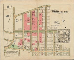
Map of Section Two Chester Hill Park City of Mount Vernon N.Y.
$500.00
Acquire
- Digital Map Information
- Suitable for large format printing
- File Size: 15.34 MB
- File Type: ZIP / TIFF
- ICC color profile embedded
- Delivered instantly via download link
An unrecorded 1910 cadastral map of the Chester Hill Park neighborhood of Mount Vernon, New York by John F. Fairchild. It demonstrates the region's rapid early 20th-century growth when suburbs sprang up in a handful of years throughout Westchester. (more details)
Commuters' Paradise.
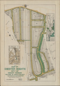
Sales Map of Chester Heights City of Mount Vernon Village of North Pelham and Town of Eastchester Westchester County N.Y.
$500.00
Acquire
- Digital Map Information
- Suitable for large format printing
- File Size: 13.02 MB
- File Type: ZIP / TIFF
- ICC color profile embedded
- Delivered instantly via download link
An unrecorded promotional cadastral map of the Chester Heights neighborhood of Mount Vernon, New York, prepared in 1913 by John F. Fairchild. It was produced as Mount Vernon and other nearby suburbs were growing rapidly due largely to new commuter train routes to New York City, including the New York, Westchester, and Boston Railway seen here. (more details)