1910 Fairchild Map of Chester Hill Park, Mount Vernon, New York
ChesterHillPark-fairchild-1910$500.00

Title
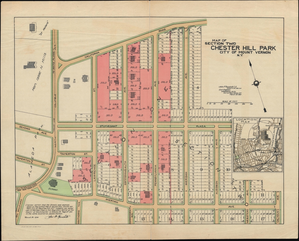
Map of Section Two Chester Hill Park City of Mount Vernon N.Y.
1910 (dated) 18 x 14 in (45.72 x 35.56 cm) 1 : 1500
1910 (dated) 18 x 14 in (45.72 x 35.56 cm) 1 : 1500
Description
An unrecorded 1910 cadastral map of the Chester Hill Park neighborhood of Mount Vernon, New York by John F. Fairchild. It demonstrates the region's rapid early 20th-century growth when suburbs sprang up in a handful of years throughout Westchester.
Some red-shaded lots already have buildings on them, some of which do not conform to the nearly laid out plan, suggesting they are older structures - the home of the 'Hon. Isaac N. Mills' appears at top-left; Mills (1851 - 1929) was a lawyer and judge elected to the New York State Senate and then the New York Supreme Court in the early 20th century.
A note explains that this map superseded 'Section 1' map of the same area produced the year prior. In fact, the rapid growth of the region caused plans to change frequently, and the area at bottom now differs significantly from the plans laid out here. Namely, the Cross-County Parkway cuts across Mount Vernon parallel to Sherman Avenue, which consequently is more diminutive than envisioned here. Nevertheless, being an early planning map of the neighborhood, this map has continued to be influential, for example, being cited in a property dispute in 2013.
A Closer Look
Oriented towards the north-northwest, this map displays residential lots in the Chester Hill Park neighborhood of Mount Vernon. The neighborhood is divided into 2 sections and 17 blocks. Lots sold are shaded red, while planned greenspace along roads is denoted with green. The trolley line along North Columbus Avenue, to the left, belonged to the Westchester Street Transportation Company. A location map inset at right displays the neighborhood in relation to nearby areas.Some red-shaded lots already have buildings on them, some of which do not conform to the nearly laid out plan, suggesting they are older structures - the home of the 'Hon. Isaac N. Mills' appears at top-left; Mills (1851 - 1929) was a lawyer and judge elected to the New York State Senate and then the New York Supreme Court in the early 20th century.
A note explains that this map superseded 'Section 1' map of the same area produced the year prior. In fact, the rapid growth of the region caused plans to change frequently, and the area at bottom now differs significantly from the plans laid out here. Namely, the Cross-County Parkway cuts across Mount Vernon parallel to Sherman Avenue, which consequently is more diminutive than envisioned here. Nevertheless, being an early planning map of the neighborhood, this map has continued to be influential, for example, being cited in a property dispute in 2013.
The Growth of Westchester
Westchester County became a popular destination for upwardly mobile residents of, or migrants to, New York City in the late 19th and early 20th century. The city was crowded, dirty, polluted, and, until public health measures were instituted, a hotbed of infectious disease. Suburbs, on the other hand, were seen as spacious, healthful, and rejuvenating - especially at the heights of the Garden City Movement. Moreover, new train lines, many now incorporated into the New York City Subway system or the Metro-North Railroad, and, eventually, automobiles, provided easy transportation to and from the city. Real estate developers and investors bought up large tracts of land, planning out subdivisions and even entire towns, selling the lots, and constructing new buildings in just a few years. For example, Mount Vernon's population grew from roughly 4,500 in 1880 to over 10,000 by 1890, with more than 10,000 new residents added in each of the following three decades as well.Publication History and Census
This map was prepared by John F. Fairbank, a local civil engineer, and printed by Charles Hart in 1910. It is unrecorded in institutional collections and has no known history on the market, though, as mentioned above, the map was cited in a recent court case, suggesting an example held in city or county archives.CartographerS
John F. Fairchild (c. 1868 - 1943) was a civil engineer and surveyor based in Mount Vernon, New York. Fairchild was born in Washington, D.C. and attended Central High School. Little is known of his upbringing or training, but he appears to have begun work as a civil engineer in Washington, D.C. around 1888. In 1890, he relocated to Mount Vernon, New York. Although he worked for the Bronx Valley Sewer Commission in the mid-1890s, most of his maps were cadastral maps of real estate lots being sold in growing neighborhoods and suburbs of Washington, D.C. and New York City. In 1899, he produced an Atlas of the City of Mount of Vernon and the Town of Pelham. Fairchild served as a major in the U.S. Army Corps of Engineers in the First World War. In 1930, he retired and relocated to Harrington Park, New Jersey, where he died in 1943. More by this mapmaker...
Charles Hart (March 10, 1824 - October 9, 1914) was a pioneering British-American lithographer active in New York from the mid-19th century to the early 20th century. Hart was born in London and immigrated to New York as a child. He briefly worked in a glassware shop before, in 1939, becoming an lithographer's apprentice under George Endicott (June 14, 1802 - 1848). Five years later in 1844 is graduated from his apprenticeship, joined the fully-paid staff of Endicott Lithography. He must have been greatly appreciated within the firm, as in 1850, his salary of 20 USD a week was among the highest in the trade. When the Endicott offices burnt to the ground in 1859, Hart moved to the firm of Robertson, Siebert and Shearman. When this partnership collapsed in 1861, Hart partnered with James Alpheus Sherman (1816 - 1890), creating the firm 'Shearman and Hart.' Shearman left the firm to peruse a legal career shortly thereafter and from this point forward, Hart published independently. Hart retired from active lithography in 1911, when his sons, Francis and Horace Hart, took over. He died in 1914. Learn More...
Condition
Very good. Light wear along original folds. Light soiling. Professionally repaired along centerfold.