
Franco, Giacomo

Giacomo Franco (1550 - c. 1620) was a Venetian engraver and publisher; in his will he described himself as 'desegnador,' and he was listed as a member of the Venetian painters' guild. He was the son of painter and engraver Battista Franco. He was regarded chiefly as an illustrator, being known mostly for two works describing Venetian costume. He published Giuseppe Rosaccio's 1605 Viaggio Da Venetia a Costantinopoli, and his imprint appears on at least one of the maps in that work - a general chart of the Turkish - held Mediterranean. He also contributed at least one map to Rosaccio's 1598 edition of Ramusio's Ptolemy, a modern map of Hungary and Transylvania. Tooley attributes a 1589 plan of Rome to him. Bifolco and Ronca identify many works belonging to Franco, including several plans of Venice, Rome, and a fine map of Cyprus.
Rare, Venetian Imprint.
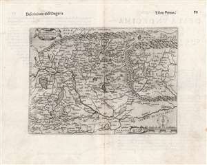
Di Hungaria et Transilvania Tavola novissima Franco for.
$600.00
Acquire
- Digital Map Information
- Suitable for large format printing
- DPI: 600
- File Size: 14.88 MB
- File Type: ZIP / TIFF
- ICC color profile embedded
- Delivered instantly via download link
This is a rare 1597 map of Hungary and Transylvania by the Venetian mapmaker Giacomo Franco. The map is credited as the work of Bernardino Valle, that draftsman's sole known work. It is derived from the cartography of János Zsámboky, probably via the intermediary of Abraham Ortelius. (more details)
First Atlas Map specifically of Cyprus.
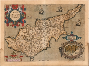
Cypri Insulae Nova Descript. 1573.
$900.00
Acquire
- Digital Map Information
- Suitable for large format printing
- Full resolution TIFF file
- ICC color profile embedded
- Delivered instantly via download link
This is a beautiful, original color example of Ortelius' 1573 map of Cyprus, combined with an inset map of Lemnos. Moreover, this is a Vrients edition of the map: maps from these editions typically exhibit finer quality color than those printed during Ortelius' lifetime and are consequently very desirable. (more details)