
Fritz, Samuel SJ

Samuel Fritz (1654 - 1728), was a Jesuit missionary born in Trutnov, Bohemia, what is now part of the Czech Republic. He took orders with the Society of Jesus, or Jesuits, in 1673. As a young Jesuit with missionary ambitions he was educated in humanistics, philosophy, and probably cartography. In 1683, he requested a missionary post in the New World and was sent to Quito where his superior, Father Lorenzo Lucero, assigned him to incorporate the Omagua tribes between the Rio Negro and the Napo River into the Maynas Missions. He spent 42 years in South America, and founded thirty-eight missions along the length of the Amazon River, in the country between the Rio Napo and Rio Negrond. His aid having been sought by the Viceroyalty of Peru in its boundary dispute with the State of Brazil, Fritz mapped the missionary territory on the Upper Maranon between Peru and Quito, resulting the first approximately correct chart of the Maranon territory. Both his map and the account of his imprisonment as a suspected Spanish spy were widely disseminated in the 18th century.
Edition of the Earliest Map of the Amazon Produced by One Who Explored It.
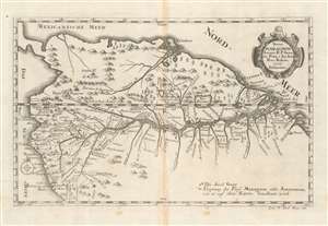
Strom Maragnon Autore R. P. Samuele Fritz, é Soc. Iesu. Prov. Bohem. 1707. Delineatus.
$500.00
Acquire
- Digital Map Information
- Suitable for large format printing
- Full resolution TIFF file
- ICC color profile embedded
- Delivered instantly via download link
This scarce 1728 Stöcklein map of the Amazon River is among the earliest acquirable maps based upon actual exploration to illustrate the full course of the Amazon River from the Andes to the Atlantic. The map is derived from the surveys of Samuel Fritz, a Czech Jesuit missionary who lived and worked in South America for over forty years. As a result of surveys intended to settle a border dispute, Fritz was able to determine the correct sources for the Marañón River, the primary source of the Amazon itself. The map shows forts, cities, and differentiates those cities with bishoprics and archbishoprics. Special notations on the map mark locations of the source of the Marañón 'as it is indicated on old maps,' and a further notation marks 'Die Insel Guar' in the middle of the Amazon. (more details)