
Fuller, Myron Leslie

Myron Leslie Fuller (fl. c. 1896 - 1927) was an American geologist and cartographer who often collaborated with the U.S. Geological Survey. He was an expert on accessing and controlling underground waters as well as seismology. He published studies in these fields based on research in various places in the United States, Europe, and China.
Long Island, from the ground up.
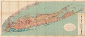
Geologic Map of Long Island, New York.
$1,000.00
Acquire
- Digital Map Information
- Suitable for large format printing
- File Size: 79.45 MB
- File Type: ZIP / TIFF
- ICC color profile embedded
- Delivered instantly via download link
This is a colorful large format 1913 geological map of Long Island made by the U.S. Geological Survey and the geologist Myron Fuller. It displays geological data, mostly defined by glacial activity in the last ice age, as well as signs of development on the island, whose population was rapidly increasing when this map was made. (more details)