1913 U.S. Geological Survey / Fuller Geologic Map of Long Island
LongIslandGeologic-geologicalsurvey-1913$1,000.00

Title
Geologic Map of Long Island, New York.
1913 (dated) 27.25 x 63.5 in (69.215 x 161.29 cm) 1 : 125000
1913 (dated) 27.25 x 63.5 in (69.215 x 161.29 cm) 1 : 125000
Description
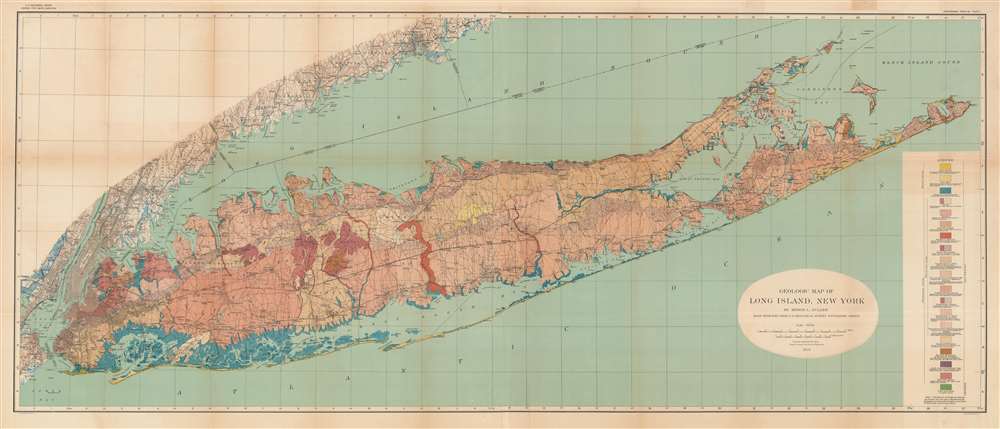
This is a colorful large format 1913 geological map of Long Island made by the U.S. Geological Survey and the geologist Myron Fuller. It displays geological data, mostly defined by glacial activity in the last ice age, as well as signs of development on the island, whose population was rapidly increasing when this map was made.
Aside from geological information, the course of railroads, roads, and waterways are illustrated. Of particular importance is the Long Island Railroad (LIRR), which opened in 1834, building off the foundation of the Brooklyn and Jamaica Railroad (1832), the first railroad on Long Island. The train line would be built out to Greenport, towards top-right, to allow for a ferry connection to Connecticut. Although this connection was soon undercut by a railroad directly to Connecticut, the LIRR continued to function, expand, and modernize, consolidating all the railroad lines on the island in the 1870s. Although essential for transportation between the city and points across Long Island, the LIRR has historically been unprofitable, requiring assistance first from the Pennsylvania Railroad and then from the State of New York and the Metropolitan Transportation Authority in the 20th and 21st centuries.
A Closer Look
This map covers the entire scope of Long Island and then some, from the shores of New Jersey and Connecticut in the west to Montauk in the east. The legend includes symbols indicating different types of sands, terrain, and rock arranged by geological era. The physical features of the island are mainly defined by the movement and melting of glaciers that occurred quite recently, in geologic terms, about 20,000 years ago. As Myron Fuller was a geologist known for his work locating and assessing water sources, it is likely that the map was primarily intended for identifying water sources for future suburban growth on the island. Until the early 20th century, Long Island was sparsely populated farming country, but the growing population of New York City and the ease of travel to the city using railroads or automobiles led to a population boom.Aside from geological information, the course of railroads, roads, and waterways are illustrated. Of particular importance is the Long Island Railroad (LIRR), which opened in 1834, building off the foundation of the Brooklyn and Jamaica Railroad (1832), the first railroad on Long Island. The train line would be built out to Greenport, towards top-right, to allow for a ferry connection to Connecticut. Although this connection was soon undercut by a railroad directly to Connecticut, the LIRR continued to function, expand, and modernize, consolidating all the railroad lines on the island in the 1870s. Although essential for transportation between the city and points across Long Island, the LIRR has historically been unprofitable, requiring assistance first from the Pennsylvania Railroad and then from the State of New York and the Metropolitan Transportation Authority in the 20th and 21st centuries.
Publication History and Census
This map was made by the geologist Myron L. Fuller, using engravings prepared by the U.S. Geological Survey and published by Julius Bien, a well-known government and commercial printer based in New York City, as a basis. In 1914, Fuller and the Geological Survey published a book titled The Geology of Long Island, New York (OCLC 699742538), which is the 'Professional Paper no. 82' referred to at top-right. Both the map, when cataloged independently, and the book are held by a small handful of libraries in North America and Europe.CartographerS
The United States Geological Survey (1878 - Present), aka the U.S.G.S., is a scientific agency of the United States government, which was founded in 1879. USGS scientists study the landscape of the United States, its natural resources, and the natural hazards that threaten it. The organization has four major science disciplines: biology, geography, geology, and hydrology. It is a bureau of the United States Department of the Interior and is the department's only scientific agency. More by this mapmaker...
Myron Leslie Fuller (fl. c. 1896 - 1927) was an American geologist and cartographer who often collaborated with the U.S. Geological Survey. He was an expert on accessing and controlling underground waters as well as seismology. He published studies in these fields based on research in various places in the United States, Europe, and China. Learn More...
Julius (Julien) Bien (September 27, 1826 - December 21, 1909) was a German-Jewish lithographer and engraver based in New York City. Bien was born in Naumburg, Germany. He was educated at the Academy of Fine Arts, Cassell and at Städel's Institute, Frankfurt-am-Main. Following the suppression of the anti-autocratic German Revolutions of 1848, Bien, who participated in the pan-German movement, found himself out of favor in his home country and joined the mass German immigration to the United States. Bien can be found in New York as early as 1849. He established the New York Lithographing, Engraving & Printing Company in New York that focused on the emergent chromo-lithograph process - a method of printing color using lithographic plates. His work drew the attention of the U.S. Government Printing Office which contracted him to produce countless government maps and surveys, including the Pacific Railroad Surveys, the census, numerous coast surveys, and various maps relating to the American Civil War. Bien also issued several atlases both privately and in conjunction with a relation, Joseph Bien. At the height of his career Bien was elected president of the American Lithographers Association. After his death in 1909, Bien's firm was taken over by his son who promptly ran it into insolvency. The firm was sold to Sheldon Franklin, who, as part of the deal, retained the right to publish under the Julius Bien imprint. In addition to his work as a printer, Bien was active in the New York German Jewish community. He was director of the New York Hebrew Technical Institute, the New York Hebrew Orphan Asylum, and president of the B'nai B'rith Order. Learn More...
Source
Myron L Fuller, Geological Survey (U.S.), The geology of Long Island, New York, U.S. Geological Survey Professional Paper 82 (1913).
Condition
Very good. Some discoloration along fold lines and in margins.
References
OCLC 955691261, 40799395.