
Germanus, Donnus Nicolaus

Donnus Nicolaus Germanus (c. 1420 – c. 1490) was a German cartographer instrumental in the 15th century dissemination and improvement of Ptolemy's Geographia, and thus was a primary mover in establishing the basis of all advances in the study of geography in the Renaissance. Nothing is known of his early life, and his full birth name is lost. (Nicolaus Germanus simply means 'Nicholas the German' and Donnus is a title: 'Master.') It is thought that as early as 1442 he was Prior of the Benedictine monastery in Baden-Württemberg. He does not appear in his role as a cosmographer until 1466, when in Florence he produced his first known revision of Ptolemy's Geography In this he was not isolated: The first such translation of the work to Latin from the Greek, by scholar Manuel Chrysoloras, was undertaken in Florence in the last years of the fourteenth century - certainly by 1400. Nicolaus did introduce several innovations to the work - notably in his introduction of the first maps to show areas not known to Ptolemy (Scandinavia in particular.) But his most important role appears to have been a disseminator of Ptolemy's work. He is known to have produced a pair of globes and a world map for the Vatican in 1477, and thereafter is credited with no fewer than fifteen manuscript copies of Geographia authored by him, or directly copied from his work. Most significantly, barring the 1482 Florence Ptolemy, all printed Geographia of the fifteenth century were copied from Nicolaus Germanus' manuscripts.
Roman-Era Egypt, as drafted by a Native Son.
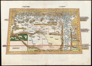
Tercia Affrice Tabula.
$11,000.00
Acquire
- Digital Map Information
- Suitable for large format printing
- Full resolution TIFF file
- ICC color profile embedded
- Delivered instantly via download link
This is a superb example, in rich original color, of one of the earliest printed maps of any part of Africa - this one focusing on the region of Libya and Egypt extending to the Red Sea, according to the second-century knowledge of Claudius Ptolemy. It appeared in the Ulm Ptolemy, the first such work printed north of the Alps, in 1482 and 1486. It is the first map of the region by someone who lived there. (more details)