1486 Claudius Ptolemy / Nicolaus Germanus Map of Ancient Egypt
Egypt-ptolemy-1486$13,500.00


Title
Tercia Affrice Tabula.
1486 (undated) 12 x 22 in (30.48 x 55.88 cm) 1 : 4300000
1486 (undated) 12 x 22 in (30.48 x 55.88 cm) 1 : 4300000
Description
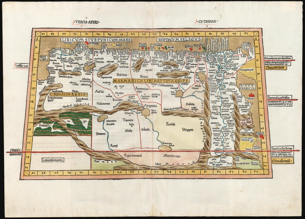
Extremely rare. This is a superb example, in rich original color, of one of the earliest printed maps of any part of Africa - this one focusing on the region of Libya and Egypt extending to the Red Sea, according to the second-century knowledge of Claudius Ptolemy. It appeared in the Ulm Ptolemy, the first such work printed north of the Alps, in 1482 and 1486. It presents the first mapping of the region by someone who lived there.
The province Cyrenaica, which corresponds nowadays to the eastern half of Libya, occupies the map's western limit. The coastal region of Pentopolis (which was part of the same Roman province as Crete) is clearly noted.
Ptolemy's Home Court
To Claudius Ptolemy, the source of this map, the subject matter was one he was intimately acquainted with: the Roman African provinces where he lived and worked between 100 and 170 CE. Politically Roman and culturally Greek, the scholar was native to Alexandria in Egypt. Consequently, none of the locations near the Mediterranean or along the lower Nile were strange to him. All these areas, accessible either by boat or Roman road, are well-detailed with place names. The map focuses particularly on the coastal provinces of Cyrenaica, Marmarica, and Aegyptus (Roman Egypt) but reaches southwards just beyond the tropic of Cancer.On The Map
The north of the map is bounded by the Mediterranean Sea: here identified with local terms, the Egyptian Sea and the Sea of Libya, or the Punic Sea. The eastern limit of the map is the Red Sea, termed by Ptolemy the Arabian Gulf. Abutting the Arabian Gulf is Roman Egypt, which mainly comprises the Nile River Valley and the lands around the Nile River Delta. Its capital, Alexandria, is noted, and at the time, it was the Roman Empire's largest port and second-largest city. The province, embracing the Lower Nile, is the best-detailed province on the map. West of Egypt is Marmarica - now the Egyptian frontier with Libya. Among its noted locations is Antipyrgus, the ancient Tobruk. The city of Ammon, marked well inland, was situated in the Siwa Oasis and was so named as a sanctuary to the deity Amun.The province Cyrenaica, which corresponds nowadays to the eastern half of Libya, occupies the map's western limit. The coastal region of Pentopolis (which was part of the same Roman province as Crete) is clearly noted.
The Harvesting Ground of the First Recorded Extinct Species
In the southern part of the province of Cyrenica beyond a mountain range is a forest region labeled 'Silfiofera Regio': this is the 'Silphium-producing land,' of great importance to classical antiquity. Silphium was a plant whose broad utility - seasoning, perfume, contraceptive, aphrodisiac - made it a vital cash crop worth its weight in silver. Such was its local importance that Cyrenian coins bore a picture of the plant. During the Roman administration of the province, Silphium went extinct - either due to Roman overharvesting of the valuable crop or by desertification in Cyrenaica. Whatever the cause, this was the first extinction of a plant or animal species in recorded history. (Legend has it that Emperor Nero devoured the last stalk, during the century prior to Ptolemy's work.) Despite the recent discovery of a plant in Turkey exhibiting many of the qualities of the ancient plant, no samples of the original Silphium survive, so it is impossible to conclusively identify modern Ferula Drudeana as the lost plant.The First Woodcut Ptolemy
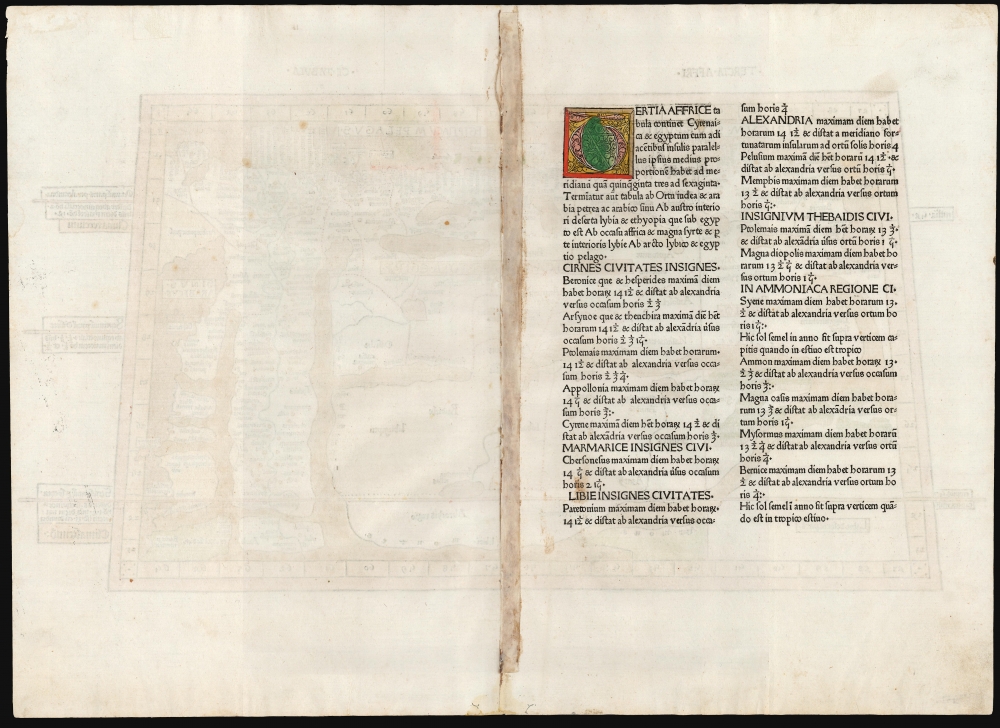
The Ulm Ptolemy was the first such work to be printed from woodblocks: the early Italian Ptolemies were printed from copperplates. The printer of the 1482 edition, Lienhart Holle, went into ruinous debt producing the book - not least due to this Ptolemy being the only one of the period to consistently receive hand coloring at the time of publication. The palette of this example is consistent with that which we have seen for examples of the 1486 edition of the work.The Definitive 15th century Ptolemy
The source for the Ulm Ptolemy - and indeed, for all but one of the fifteenth-century printed Ptolemies - was Donnus Nicolaus Germanus (c. 1420 - c. 1490) whose manuscript translations were instrumental in spreading knowledge of it out of Italy: he represented the most influential disseminator of Ptolemy's work. Barring the 1482 Florence Ptolemy, all printed Geographia of the 15th century were copied from Nicolaus Germanus' manuscripts. The forest pictured around this map's Silfiofera Regio, for example, appeared in the Ptolemies sourced from Germanus' manuscripts but was not pictured in the 1482 Berlinghieri (which also chose a different spelling for the locale, 'Silphiophora Regio'.)Publication History and Census
The woodcut for this map was made by the formschneider Johann Schnitzer de Armsheim for inclusion in the 1482 Holle edition of Ptolemy's Geography, titled by its translators at the time Cosmography. After Holle's patron, Justus de Albano, seized the blocks for nonpayment of the printer's debts, Albano commissioned a second edition of the work to be printed from the same blocks by the printer Johann Reger in 1486. There were no further editions using these blocks. While there is no distinction between the two states' printed images, the coloring used differs, mainly in Holle's profligate use of Lapiz Lazuli in coloring large bodies of water. Reger economized in the use of that deep (and prohibitively expensive) blue, restricting it to rivers and lakes, and the maps of the 1486 Reger edition characteristically have the seas and oceans filled with a tawny-brown color (which may once have been a brighter color.) We see 18 examples of the Holle Ptolemy in institutional collections and 10 of the Reger. No examples of the separate map are cataloged in OCLC. We see only two examples of this map that have reached the market in the past 40 years, of which this is one.CartographerS
Claudius Ptolemy (83 - 161 AD) is considered to be the father of cartography. A native of Alexandria living at the height of the Roman Empire, Ptolemy was renowned as a student of Astronomy and Geography. His work as an astronomer, as published in his Almagest, held considerable influence over western thought until Isaac Newton. His cartographic influence remains to this day. Ptolemy was the first to introduce projection techniques and to publish an atlas, the Geographiae. Ptolemy based his geographical and historical information on the "Geographiae" of Strabo, the cartographic materials assembled by Marinus of Tyre, and contemporary accounts provided by the many traders and navigators passing through Alexandria. Ptolemy's Geographiae was a groundbreaking achievement far in advance of any known pre-existent cartography, not for any accuracy in its data, but in his method. His projection of a conic portion of the globe on a grid, and his meticulous tabulation of the known cities and geographical features of his world, allowed scholars for the first time to produce a mathematical model of the world's surface. In this, Ptolemy's work provided the foundation for all mapmaking to follow. His errors in the estimation of the size of the globe (more than twenty percent too small) resulted in Columbus's fateful expedition to India in 1492.
Ptolemy's text was lost to Western Europe in the middle ages, but survived in the Arab world and was passed along to the Greek world. Although the original text almost certainly did not include maps, the instructions contained in the text of Ptolemy's Geographiae allowed the execution of such maps. When vellum and paper books became available, manuscript examples of Ptolemy began to include maps. The earliest known manuscript Geographias survive from the fourteenth century; of Ptolemies that have come down to us today are based upon the manuscript editions produced in the mid 15th century by Donnus Nicolaus Germanus, who provided the basis for all but one of the printed fifteenth century editions of the work. More by this mapmaker...
Donnus Nicolaus Germanus (c. 1420 – c. 1490) was a German cartographer instrumental in the 15th century dissemination and improvement of Ptolemy's Geographia, and thus was a primary mover in establishing the basis of all advances in the study of geography in the Renaissance. Nothing is known of his early life, and his full birth name is lost. (Nicolaus Germanus simply means 'Nicholas the German' and Donnus is a title: 'Master.') It is thought that as early as 1442 he was Prior of the Benedictine monastery in Baden-Württemberg. He does not appear in his role as a cosmographer until 1466, when in Florence he produced his first known revision of Ptolemy's Geography In this he was not isolated: The first such translation of the work to Latin from the Greek, by scholar Manuel Chrysoloras, was undertaken in Florence in the last years of the fourteenth century - certainly by 1400. Nicolaus did introduce several innovations to the work - notably in his introduction of the first maps to show areas not known to Ptolemy (Scandinavia in particular.) But his most important role appears to have been a disseminator of Ptolemy's work. He is known to have produced a pair of globes and a world map for the Vatican in 1477, and thereafter is credited with no fewer than fifteen manuscript copies of Geographia authored by him, or directly copied from his work. Most significantly, barring the 1482 Florence Ptolemy, all printed Geographia of the fifteenth century were copied from Nicolaus Germanus' manuscripts. Learn More...
Lienhart Holle (? - 1492) was a German printer, living and working in Ulm. He is most noted for his 1482 Ptolemy, the first edition of Geographia printed north of the Alps. Little is known of his life. He appears in the historical record in 1478 as a formschneider and woodcut dealer, among other things printing playing cards. He would then become the third book printer in Ulm, producing some outstanding works of the incunable period, most notably his edition of Ptolemy. Masterpiece though this was, it ruined him financially within two years of its publication. The elaborate designs of his books made them extravagantly expensive to produce, and he could only raise the capital by borrowing it, mortgaging his printing materials to a Venetian patron, Justus de Albano. As with many early printed works, a broad market failed to materialize, and Holle was unable to pay his debts. De Albano seized the blocks and typeset for nonpayment, and Holle was forced to flee Ulm in 1484. He is thought to have attempted a return to the city in later years but there is no record of him that appears after 1492. Learn More...
Johann Reger (fl. 1480-1499) was a German printer living and working in Ulm at the end of the 15th century. While most of his output was not illustrious, he was employed by Venetian investor and patron Justus de Albano to print an edition of Ptolemy's Geographia using the blocks and typeset produced by Lienhart Holle for the 1482 edition of that work. (Holle had mortgaged this printing material to Albano, who subsequently seized it for nonpayment.) Reger completed this Albano edition of Ptolemy in 1486. Learn More...
Source
Ptolemy, C. / Germanus, Donnus Nicolaus, Claudii Ptolomei viri Alexandrini Cosmographie... opus Domini Nicolai Germani secundum Ptolomeum finit, (Ulm: Reger, Johannes) 1486.
Condition
Excellent. Few marginal specks, else a fine, untrimmed example with original color.
References
cf. Afriterra #322 (1482.) Norwich, O., Norwich's Maps of Africa: An illustrated and Annotated Carto-bibliography, cf.#1.