
Hill, Samuel

Samuel Hill (July 27, 1750 - 1809) was a Boston-based engraver and copperplate printer active in the late 18th and early 19th centuries. He was born in Massachusetts, the son of Alexander and Thankful (Allen) Hill. Hill was a generalist engraver who published in Massachusetts Magazine, Defoe's New Robinson Crusoe (1790); Lavater's Essays on Physiognomy (1794); as well as maps for the American Universal Geography (1796); Cook's Three Voyages to the Pacific Ocean (1797), Osgood Carleton (1801), and others. He is best known for engraving one of the first maps of Washington D.C. in 1792. Hill maintained an office at 2 Cornhill, Boston.
First Official Map of Massachusetts.
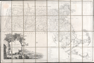
Map of Massachusetts Proper Compiled form Actual Surveys made by Order of the General Court, and under the inspection of Agents of their appointment, by Osgood Carleton.
$7,800.00
Acquire
- Digital Map Information
- Suitable for large format printing
- Full resolution TIFF file
- ICC color profile embedded
- Delivered instantly via download link
Known as 'The Agent's Map', this is a fine example of the first official map of Massachusetts, published in 1801 by Osgood Carleton. The map emerged out of a long and complex struggle to produce a large-scale, accurate, and comprehensive state map - something increasingly important in the heady early days of independence following the American Revolutionary War (1775 - 1783). (more details)