
Hotchkiss, Charles Jerome

Charles Jerome Hotchkiss (December 11, 1887 - November 12, 1950) was a Denver-based map publisher active in the middle part of the 20th century. Hotchkiss was born in Pontiac, Michigan. He served in the Michigan National Guard, achieving the rank of private. We find him in Denver as early as 1909, when he married Esther J. Frinche. By 1910 he was working as a freight insurance auditor for the Colorado and Southern Railroad. He started the Hotchkiss map company in 1933 and, in 1934, advertisements name him 'Successor to Clason Map Co.' At that time, he also continued his practice as a 'freight auditor.' Hotchkiss republished many of Clason's maps, updating and revising them as needed. The business operated at least until his death in 1950. Hotchkiss was also an active Freemason at the 33rd degree.
Striking whiteprint wall map of Denver.
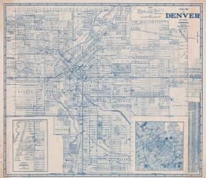
Guide Map of Denver and Suburbs Colorado.
$950.00
Acquire
- Digital Map Information
- Suitable for large format printing
- File Size: 74.65 MB
- File Type: ZIP / TIFF
- ICC color profile embedded
- Delivered instantly via download link
This is a striking diazo or whiteprint c. 1946 wall map of Denver, Colorado, by the locally based Hotchkiss Map Company. Centered on Capitol Hill, this map covers all of Denver from Lakeside Lake to Aurora and from 54th Avenue to Englewood. An inset map of Englewood occupies the lower left, while another inset on the lower right details the Denver Business District. The map is highly detailed, showing streets, individual buildings, parks, route numbers, railway lines, churches, schools, and other features. It is extremely large - not to be confused with Hotchkiss' smaller but otherwise similar map appearing in his Denver guide. The diazo medium necessarily limits the number of maps produced - thus underscoring this map's exceptional nature. (more details)