
James, Henry

Sir Henry James (1803 - 1877) was the director-general of the Ordnance Survey, the mapping agency of the British government, from 1854 to 1875. He studied at the Royal Military Academy and was commissioned as a second lieutenant in the Royal Engineers on September 22, 1826. He joined the Ordnance Survey in 1827 and spent the majority of his career there, except for a brief stint at the Admiralty. He became Superintendent of the Ordnance Survey in 1854. Upon taking over the Ordnance Survey, he became involved in the 'battle of the scales'. It had long been debated which maps should be made and what scale would be the most useful. Sir Henry was a firm believer in the 1 : 2500 scale, and, due to his position, imposed this belief upon the Survey despite the less than full approval of his superiors. Sir Henry created a photography department at the Ordnance Survey in 1855 as a means of reducing the scale of maps. He claimed to have invented photozincography, a photographic method of producing printing plates. However, the process had in fact been developed by two members of his staff. Nonetheless, James was the driving force behind using the process to create and publish a facsimile of the Domesday Book in the 1860s. He also used this photozincographic process to preserve historic manuscripts.
Highlights the 'Terrestrial Hemisphere' on a newly-conceived projection.
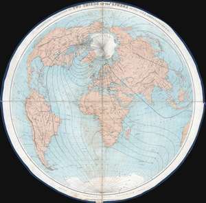
Geometrical Projection of Two Thirds of the Sphere. (Africa Central).
$750.00
Acquire
- Digital Map Information
- Suitable for large format printing
- File Size: 27.56 MB
- File Type: ZIP / TIFF
- ICC color profile embedded
- Delivered instantly via download link
This is an 1860 Henry James geometrical projection circular map of two-thirds of the world, focusing on the 'terrestrial hemisphere'. Centered on northern Africa, the world appears as if on the inside of a sphere. Dashed lines represent lines of longitude. Some countries, although not all, are labeled. A handful of cities are identified as well, including the major meridian cities: London, Paris, Rome, New York, and Washington, D.C. (more details)