
Jefferson, Peter

Peter Jefferson (February 29, 1708 - August 17, 1757) was a planter, cartographer and politician best known as the father of US President Thomas Jefferson (1743–1826). In collaboration with surveyor Joshua Fry, he produced in 1751 the so-called 'Fry-Jefferson Map'. Jefferson was born in the Virginia Colony at Osbornes on the James River, the son of a large property owner. He received no formal education in his youth, but was a well-read autodidact. He inherited land, becoming a prosperous plantation owner, slave owner, sheriff, surveyor and justice of the peace. He was also a surveyor and mapmaker: in 1749 he collaborated with Joshua Fry in the production of their 1751 A Map of the most Inhabited part of Virginia containing the whole Province of Maryland, which accurately depicted the Allegheny Mountains for the first time and showed the route of what would later be known as the Great Wagon Road.
Elegant Edition of the Pinnacle of the Colonial Mapping of Virginia.
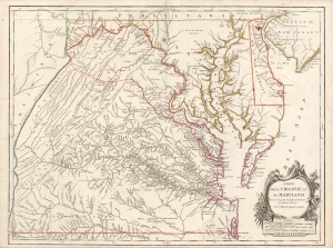
Carte de la Virginie et du Maryland Dressée sur la grande carte Angloise de Mrs. Josué Fry et Pierre Jefferson, Par le Sr. Robert de Vaugondy Géographe.
$2,200.00
Acquire
- Digital Map Information
- Suitable for large format printing
- Full resolution TIFF file
- ICC color profile embedded
- Delivered instantly via download link
This is Robert de Vaugondy's 1755 map of Virginia and Maryland, here in an attractive example of the 1793 5th state. (more details)