1793 Vaugondy / Fry / Jefferson Map of Virginia, Maryland and Delaware
VirginiaMaryland-vaugondy-1755$2,200.00

Title
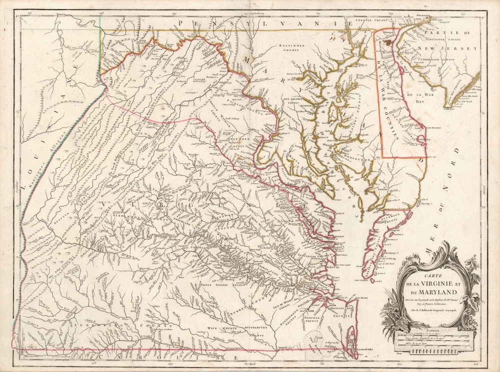
Carte de la Virginie et du Maryland Dressée sur la grande carte Angloise de Mrs. Josué Fry et Pierre Jefferson, Par le Sr. Robert de Vaugondy Géographe.
1755 (undated) 19 x 25.5 in (48.26 x 64.77 cm) 1 : 870000
1755 (undated) 19 x 25.5 in (48.26 x 64.77 cm) 1 : 870000
Description
This is Robert de Vaugondy's 1755 map of Virginia and Maryland, here in an attractive example of the 1793 5th state.
A Closer Look
The map is a reduced, yet richly-detailed French edition of Joshua Fry and Peter Jefferson's 1755 A Map of the most Inhabited part of Virginia containing the whole Province of Maryland... The monumental Fry-Jefferson, a semi-official map based on new surveys, was the foremost map of its region for the second half of the eighteenth century. The map compiles Fry and Jefferson's 1746 survey of Lord Fairfax's lands in the Piedmont region of Virginia, and their 1749 and 1750 surveys of Virginia's boundaries with North Carolina and Maryland. It was the first printed map to approximate the parallel ridges and valleys of the Appalachian Mountains. Its great detail - both in the settled eastern part of the colony, and in the western frontier region - emphasizes the importance of this provincial map during a period characterized by a westward settlement push. The original Fry-Jefferson map was commissioned by the English Lords of Trade, who in 1750 required each American colony to execute a complete survey. Joshua Fry and Peter Jefferson had already executed several relevant surveys (noted above) and were tasked to undertake the whole commission. Their map was completed in 1751. Vaugondy's single-sheet reduction was executed in 1755, based on a revision of the Fry-Jefferson map completed that same year.Publication History and Census
This map was engraved by Delahaye in 1755 for inclusion in Vaugondy's Atlas Universel. The etching of the cartouche was done by the scientific illustrator and engraver Élisabeth Haussard, whose imprint appeared on the first two states of the map. When the publication of the Vaugondy atlas was taken over by Jean-Baptiste Fortin in 1778, the engraver Charles-Jacques Groux replaced Haussard's signature with his own. (This, despite no evidence Groux did any other work beyond the burnishing away of Vaugondy's privilege and titles, and of the 1755 date.) The presence of the Groux imprint, the absence of Vaugondy's title 'Ordinaire du Roi,' and the removal of the 1755 date marks this as the fifth and final state of the map, printed c. 1793.CartographerS
Robert de Vaugondy (fl. c. 1716 - 1786) was French may publishing from run by brothers Gilles (1688 - 1766) and Didier (c. 1723 - 1786) Robert de Vaugondy. They were map publishers, engravers, and cartographers active in Paris during the mid-18th century. The father and son team were the inheritors to the important Nicolas Sanson (1600 - 1667) cartographic firm whose stock supplied much of their initial material. Graduating from Sanson's maps, Gilles, and more particularly Didier, began to produce their own substantial corpus. The Vaugondys were well-respected for the detail and accuracy of their maps, for which they capitalized on the resources of 18th-century Paris to compile the most accurate and fantasy-free maps possible. The Vaugondys compiled each map based on their own geographic knowledge, scholarly research, journals of contemporary explorers and missionaries, and direct astronomical observation. Moreover, unlike many cartographers of this period, they took pains to reference their sources. Nevertheless, even in 18th-century Paris, geographical knowledge was limited - especially regarding those unexplored portions of the world, including the poles, the Pacific Northwest of America, and the interiors of Africa, Australia, and South America. In these areas, the Vaugondys, like their rivals De L'Isle and Buache, must be considered speculative or positivist geographers. Speculative geography was a genre of mapmaking that evolved in Europe, particularly Paris, in the middle to late 18th century. Cartographers in this genre would fill in unknown lands with theories based on their knowledge of cartography, personal geographical theories, and often dubious primary source material gathered by explorers. This approach, which attempted to use the known to validate the unknown, naturally engendered rivalries. Vaugondy's feuds with other cartographers, most specifically Phillipe Buache, resulted in numerous conflicting papers presented before the Academie des Sciences, of which both were members. The era of speculative cartography effectively ended with the late 18th-century explorations of Captain Cook, Jean Francois de Galaup de La Perouse, and George Vancouver. After Didier died, his maps were acquired by Jean-Baptiste Fortin, who in 1787 sold them to Charles-François Delamarche (1740 - 1817). While Delamarche prospered from the Vaugondy maps, he defrauded Vaugondy's window Marie Louise Rosalie Dangy of her rightful inheritance and may even have killed her. More by this mapmaker...
Joshua Fry (1699–1754) was an English adventurer, professor, investor who became an official in the colony of Virginia. He is best known as a surveyor and cartographer who collaborated with Peter Jefferson, the father of future U.S. president Thomas Jefferson in producing the quintessential colonial map of Virginia and Maryland.
Fry was born in Somerset, England, and educated at Oxford. He sought his fortune in the colonies, emigrating to Virginia in 1726. There he would marry and raise a large family. He would become a professor of mathematics and natural philosophy. After marrying a young widow, he would give up his professorship to operate her plantation. At that time he would begin a public career as a judge but would also buy and sell real estate, and worked as well as a surveyor. In 1746 Fry and Peter Jefferson were commissioned to survey Lord Fairfax's lands in the Piedmont region of Virginia, and three years later the two were tasked with surveying the boundary with North Carolina. In 1750 they would be assigned to survey the border with Maryland as well. On the strength of these and other surveys, Fry and Jefferson would produce their 1751 masterpiece map, A Map of the most Inhabited part of Virginia containing the whole Province of Maryland. Fry had served as colonel in Albemarle County's militia, and at the beginning of the French and Indian War he was named Commander-in-Chief of colonial forces, given command of the Virginia Regiment, and ordered to capture Fort Duquesne from the French. On the way, he fell from his horse and died from the resultant injuries. He was succeeded in command of the Virginia Regiment by a young officer named George Washington. Learn More...
Peter Jefferson (February 29, 1708 - August 17, 1757) was a planter, cartographer and politician best known as the father of US President Thomas Jefferson (1743–1826). In collaboration with surveyor Joshua Fry, he produced in 1751 the so-called 'Fry-Jefferson Map'. Jefferson was born in the Virginia Colony at Osbornes on the James River, the son of a large property owner. He received no formal education in his youth, but was a well-read autodidact. He inherited land, becoming a prosperous plantation owner, slave owner, sheriff, surveyor and justice of the peace. He was also a surveyor and mapmaker: in 1749 he collaborated with Joshua Fry in the production of their 1751 A Map of the most Inhabited part of Virginia containing the whole Province of Maryland, which accurately depicted the Allegheny Mountains for the first time and showed the route of what would later be known as the Great Wagon Road. Learn More...
Élisabeth Haussard (1700-1804) was a French scientific illustrator and engraver/etcher. She was thee youngest daughter of engraver Jean-Baptiste Haussard. She participated in the family trade, engraving illustrations for scientific and technical works, and specialising in etched cartouches for geographical maps: many of these appeared in Robert de Vaugondy's atlases. While later editions of Vaugondy's work show the imprint of Charles-Jacques Groux in place of that of Haussard, there is no evidence that Groux replaced any part of Haussard's bravura etching. Learn More...
Guillaume-Nicolas Delahaye (1725 - February 24, 1802) was the most prolific member of the Delahaye (De-La-Haye) family of engravers active in Paris throughout the 18th century. Given that the name, Delahaye literally translates to 'of the Hague' it can be assume they were French Huguenots who were forced to flee the Netherlands under threat of religious persecution. Born in Paris, he was the son of patriarch Jean-Baptiste Delahaye and brother to Jean-Baptistie-Henri Delahaye. It is said that his godfather, who held him at the baptismal font, was none other than the famous french cartographer Guillaume de L'Isle. The Delahaye family engraved for many of the great cartographers of 18th century Paris, including Jean-Baptiste Bourguignon d'Anville, Didier Robert de Vaugondy, Jean-Baptiste de Mannevillette, and Jean-Nicolas Buache, among others. He was awarded the public office Premier Graveur du Roi and worked on a series of maps illustrating the king's hunts around Versailles. Guillaume also worked with foreign cartographers such as Tomas Lopez of Madrid. Possibly Delahaye's most significant map is A Map of the Country between Albemarle Sound and Lake Erie prepared for the memories of Thomas Jefferson. He married in 1758. In total he engraved some 1200 maps. Delahaye died in Charenton. In 1792, his daughter, Antoinette Marie Delahaye (1773-1857), married the geographer Jean-Denis Barbie du Bocage. Learn More...
Source
Robert de Vaugondy, G., Atlas Universel (Paris: Delamarche) 1793.
The Atlas Universel was the crowning glory of the Robert de Vaugondy firm's atlas production. The atlas was revolutionary on many levels and exemplified the Vaugondy credo commode, complet, univorme, et suive (convenient, complete, uniform, and easy to use). The atlas thus consisted of a wide corpus of maps, both modern and historical, was of moderate height and width, and featured maps of uniform style and structure. They partnered with Antoine Boudet, a shrewd businessman and publisher with whom they had worked previously, to produce the 1752 first edition. To minimize his fiscal risk, Boudet sold the atlas first by subscription using a large prospectus, receiving in the process over 1100 pre-orders. The first edition appeared in 1752 and contained beautifully produced maps with elaborate freshly designed allegorical cartouche work, generally by Pierre-Edme Babel, Pierre Philippe Choffard, and Charles Nicholas Cochin. Most of the maps were engraved by the Delahaye firm, the payment for whose services ultimately led to legal disputes. Despite proving a popular work of astounding quality, the Atlas Universal received harsh criticism from fellow cartographers, particularly Philipppe Buache. Ever at odds with the Vaugondys, Buache's critical perspective may have been influenced more by political maneuvering than academic affront. The atlas was issued in multiple editions between 1752 and 1788. Later editions, issued after 1786, were taken over by Charles Delamarche, who inherited the Robert de Vaugondy firm and assumed Boudet's publication rights.
Condition
Very good. Some minor scuffing, and few spots on surface. Original outline color.
References
OCLC 166643203. Pedley, M. Bel Et Utile #470. Rumsey 3353.101 (1755 first state.) Stephenson and McKee Virginia in Maps Map II-21A-D.