
Langhans, Paul Max Harry

Paul Max Harry Langhans (April 1, 1867 - January 17, 1952) was a German cartographer and geographer. Langhans was born in Hamburg, the son of an innkeeper. He attended secondary school from 1878 to 1886 in Hamburg. Then, in Kiel and Leipzig from 1886 to 1889, studied natural sciences, economics, and geography. He started working for Justus Perthes's Geographisch-kartographischen Anstalt in 1889 and created maps and atlases for the company during the following decades. Langhans worked as the editor of Petermanns Geographische Mitteilungen from 1909 until 1937 and was the editor-in-chief of Gothaischer Hofkalender beginning in 1923. Considered to be one of the most important German representatives of ethnocentric geopolitics, Langhans, founded the magazine Deutsche Erde in 1902, which supported folk and cultural soil research and was close to the Pan-German Association. He was a member of the German Social Reform party, an anti-Semitic political party, and worked as editor of the Antisemitic Monthly Gazette from 1896 to 1907. IN 1931, Langhans joined the National Socialist German Workers' Party (NAZI). He worked as a training speaker in Schönau vor dem Walde at the NSDAP district school. He was married to Rosa Langhans (born Rasch, 1870 - 1960) with whom he had a daughter.
Last Stage of the 'Great Game'.
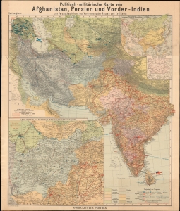
Politisch-militärische Karte von Afghanistan, Persien und Vorder-Indien : zur Veranschaulichung des Vordringens der Russen und Engländer.
$950.00
Acquire
- Digital Map Information
- Suitable for large format printing
- Full resolution TIFF file
- ICC color profile embedded
- Delivered instantly via download link
An intriguing c. 1900 by Paul Langhans map of Central and South Asia, focusing on Afghanistan. It coincided with the last stage of the 'Great Game' competition between Russia and Great Britain, whose military forces throughout the region are meticulously cataloged. (more details)