
Long, Everette Beach

Everette Beach 'Pete' Long (October 24, 1919 - March 31, 1981) was an American journalist and American Civil War scholar, author, and professor. Born in Whitehall, Wisconsin, Long attended Miami University at Oxford, Ohio, and Northwestern University. After graduating he worked in Chicago for the Associated Press for eight years and then worked for the Chicago Tribune as a financial reporter for two years. Long would say that one day in 1944 he walked into Ralph Newman's Abraham Lincoln Book Shop in Chicago and 'figuratively never walked out'. He liked to say that 'I got interested in the Civil War as a hobby. Then it became an avocation, then a way of life'. Long published numerous books on the subject. As Luck Would Have It, a discussion of 'might-have-beens' of the U.S. Civil War, appeared in 1948. The Civil War Digest, which he cowrote with Ralph Newman, was published in 1960. Long also worked as the chief researcher for two other prominent American Civil War historians: Bruce Catton and Allan Nevins. Long was hired as an instructor at the University of Wyoming in 1969 and published his landmark The Civil War Day by Day not long after, which earned him a full professorship at the University of Wyoming. His nine million words of notes, gathered from over 125 U.S. libraries and archives, are now part of the manuscript collection at the Library of Congress. Long died of a heart attack in Chicago after giving a lecture and an autograph party at the Abraham Lincoln Book Shop in 1981.
Commemorates the centennial of the American Civil War.
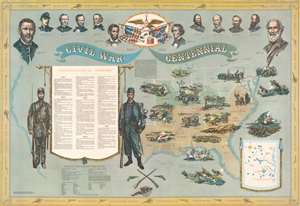
This is a 1960 Ralph G. Newman and E.B. Long broadside pictorial map of the eastern United States and American Civil War battle locations. Commemorating the centennial of the American Civil War, a map of the eastern United States occupies half the sheet and is shaded to illustrate the Union, the Confederacy, and the two 'border states' (Missouri and Kentucky). Pictorial vignettes illustrate the Draft Riots in New York City, the bombardment of Fort Sumter, the Battle of Gettysburg, and the surrender at Appomattox, among other events. Sixty-four events, listed in chronological order, appear on a banner to the left. Each event is numerically labeled and corresponds with a number on the map or on the inset map of Virginia situated in the lower right. Illustrations of Union and Confederate soldiers flank this banner. Portraits of Union and Confederate leaders, including Abraham Lincoln, Ulysses S. Grant, William T. Sherman, Jefferson Davis, and Robert E. Lee appear along the top border. Names of important battles in chronological order adorn the border and are separated by illustrations of cannons and pistols. (more details)