
Lopez, Juan

Juan Lopez (1765 - 1825) was Spanish cartographer, map publisher, and map dealer active in Spain in the late 18th and early 19th centuries. Juan Lopez is credited with the first printed edition of Barriero’s highly important 1728 manuscript map, considered the first of Texas by a trained surveyor. Although Tooley’s Dictionary of Mapmakers (K-P, p. 155) asserts that Juan Lopez was not the son of great Spanish cartographer, Tomás Lopez (1730 - 1802), other evidence suggests he most certainly was. There are multiple Lopez catalogs issued in the late 18th century that cite both Juan and Tomás Lopez, including the catalog entry for this very map. He became Geógrafo del Rey to Carlos IV in 1795. Lopez continued producing map to about 1820.
Spain eyes Britain's most profitable West Indian colony.
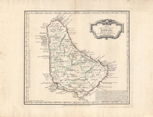
Carta de la isla de la Barbada.
$2,000.00
Acquire
- Digital Map Information
- Suitable for large format printing
- DPI: 600
- File Size: 46.89 MB
- File Type: ZIP / TIFF
- ICC color profile embedded
- Delivered instantly via download link
This is a 1780 map of Barbados by Juan Lopez, who later became the 'geographer to the king' of Spain. The map emerged from ongoing power struggles between Britain and Spain over colonial dominance of the West Indies. Here, Lopez provides key details, including notations of military fortifications, that would have been invaluable to Spanish efforts to seize the lucrative island. (more details)