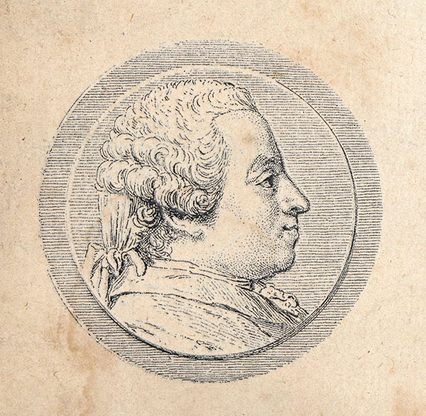
Tomás López de Vargas Machuca (1730 - July 19, 1802) was a Spanish cartographer active in the later part of the 18th century. Vargas was born in Toledo and studied mathematics, grammar, and rhetoric at the Colegio Imperial in Madrid. In 1752, with the patronage of the Marquis de la Ensenada, he relocated to Paris to study. López attended the Mazarin College, where he received two courses in Mathematics and lessons in geography from the Abbé de la Caille, Joseph Jérome de Lalande, and Louis Gabriel. He also studied cartography direclty under the legendary French mapmaker Jean Baptiste Bourguignon d'Anville (1697 - 1782). Back in Madrid, he collaborated with the geographer Juan de la Cruz on two educational atlases, published in 1757 and 1758. Around 1770, King Carolos III, appointed him Geógrafo de los Dominios de Su Magestad and gave him charge over the newly created Gabinete de Geografía. In this position, he dedicated the remainder of his life to a detailed mapping of Spain, producing numerous important regional maps, many correcting common mistakes made by foreign geographers. He also ran a private map publishing business in Madrid, first on San Bernardo (1761 - 65), the on Las Carretas (opposite Gamete; 1765 - 1783), and infamy on Atocha (1783 - 1802). He was a member of the Real Academia de San Fernando, the Real Sociedad Bascongada de Amigos del País and the Academia de Bellas Letras de Sevilla. López was succeeded by his two sons, also cartographers, who published several atlases based upon his work. The appraisal of his estate at the time was 489,800 reales (about 1,000,000 USD today), a figure indicative of his success.