
Matthews, George

George Matthews (fl. c. 1840 - 1864) was an engraver and printer based in Montreal. He was best known early in his career for working with the artist James Duncan to produce a set of lithographed views of Montreal in 1843. Having established himself as a leading figure in Montreal's printing industry, in 1864 Matthews sold his business to a younger group of printers that became known as Burland-Lafrican and Co.
From Europe to the Pacific.
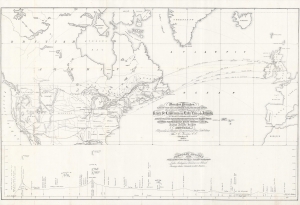
Mercator's Projection. With the Great Circle (Shortest Sailing) or Air Lines, Illustrating the directness and capacity of the River St. Lawrence from Lake Erie to the Atlantic. As a means of communication between Europe and the Commercial Centre of the Great West, Shewing also the Extension of the Northern Pacific Railway Route Through Canada, to the Nearest Atlantic Seaport at Montreal.
$1,200.00
Acquire
- Digital Map Information
- Suitable for large format printing
- File Size: 27.62 MB
- File Type: ZIP / TIFF
- ICC color profile embedded
- Delivered instantly via download link
A captivating large-format work reflecting both ambition and vision, this is Thomas Keefer's 1855 map of potential future connections linking western Europe to North America and the Pacific via transcontinental railways and steamers. It was prepared for the Canadian Commission to the 1855 Exposition Universelle in Paris. (more details)