1855 Keefer Map of Rail and Sea Lines, Europe to the Pacific
StLawrenceAtlantic-keefer-1855$1,200.00


Title
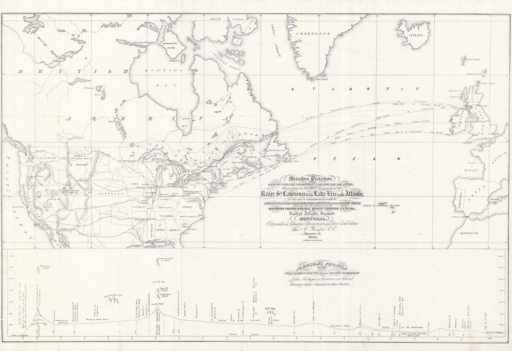
Mercator's Projection. With the Great Circle (Shortest Sailing) or Air Lines, Illustrating the directness and capacity of the River St. Lawrence from Lake Erie to the Atlantic. As a means of communication between Europe and the Commercial Centre of the Great West, Shewing also the Extension of the Northern Pacific Railway Route Through Canada, to the Nearest Atlantic Seaport at Montreal.
1855 (dated) 22.5 x 34.75 in (57.15 x 88.265 cm) 1 : 13300000
1855 (dated) 22.5 x 34.75 in (57.15 x 88.265 cm) 1 : 13300000
Description
A captivating large-format work reflecting both ambition and vision, this is Thomas Keefer's 1855 map of potential future connections linking western Europe to North America and the Pacific via transcontinental railways and steamers. It was prepared for the Canadian Commission to the 1855 Exposition Universelle in Paris.
The bottom third of the sheet includes 'Johnson's profile of the northern route for the Pacific Railroad, from Lake Michigan to Vancouver Island' displaying elevations and river crossings along the proposed route. This schematic was not produced by the prolific American cartographer Alvin Jewitt Johnson, but instead Edwin Ferry Johnson, a civil engineer who championed transcontinental rail and became chief engineer of the Northern Pacific Railway in 1867.
A Closer Look
Focusing on North America and the North Atlantic, various means of long-distance transportation are depicted, including steamers across the Atlantic, existing railroads in North America, and potential future lines to the Pacific Coast ('air lines' here refer to the most direct routes between two points, equivalent to 'as the bird flies,' reflecting the curvature of the Earth. The northern rail route (similar to the later route of the Northern Pacific Railway, chartered in 1864) is highlighted, while lines connecting New Orleans, Memphis, St. Louis, and Chicago to California are also included. Keefer appears to presage the development of the West Coast, with lines terminating near future metropolises of Los Angeles, Portland, and Seattle, as well as San Francisco, which was already growing rapidly. Being based in Vancouver, Keefer is keen to emphasize the centrality of the St. Lawrence River, Montreal, and the Great Lakes to this ambitious enterprise of linking Europe to the Pacific via North America.The bottom third of the sheet includes 'Johnson's profile of the northern route for the Pacific Railroad, from Lake Michigan to Vancouver Island' displaying elevations and river crossings along the proposed route. This schematic was not produced by the prolific American cartographer Alvin Jewitt Johnson, but instead Edwin Ferry Johnson, a civil engineer who championed transcontinental rail and became chief engineer of the Northern Pacific Railway in 1867.
Constructing Canadian Identity
In the years prior to this map's publication, a succession of British colonies in North America (future Canadian provinces) achieved 'responsible government,' providing them greater autonomy. For many proponents of a transcontinental transportation route traversing part of these territories, the establishment of such a line would aid in developing a unified and distinct identity, a precursor to greater independence, which was effectively achieved with Dominion status in 1867. Montreal, and Quebec writ large, fit somewhat awkwardly within this project - maintaining peace between French-speaking Catholics and English-speaking Protestants was an important part of the devolution of power from the British Parliament, but at the same time, Quebecois were deeply concerned that they would be outnumbered and their interests ignored in a mostly English-speaking unified Canada. These concerns lay at the core of Canada's federal system and mostly autonomous government in Quebec, while also leading the English-speaking population to retain a strong identification with the British Empire, even while becoming more distant from it in matters of government.1855 Exposition Universelle
The Exposition Universelle held in Paris in 1855 was a grand affair. France had recently gone through a spell of upheaval, resulting in Louis-Napoléon Bonaparte, a nephew of the great emperor, becoming President and then declaring himself emperor (as Napoleon III) in emulation of his uncle in 1851. In power for more than twenty years, Louis-Napoléon championed modernization and overseas expansion, attempting to match Great Britain's aplomb in both categories. The 1855 Exposition Universelle was in part an answer to the 1851 Great Exposition in London, which displayed many innovative and advanced technologies that would define modern life in the following decades, not to mention artistic works, colonial exhibits, and expensive rare stones. Though it attracted over 5 million visitors from near and far, the Exposition Universelle did not quite match its predecessor in London and was an expensive endeavor for the French government, costing considerably more than it took in. All the same, it was an important opportunity to exhibit France's aspirations to the world while also showcasing new and experimental technologies.Publication History and Census
This map was prepared by Thomas Keefer and printed by George Matthews in 1855 for the Canadian Commissioners of the Paris Exhibition. Later editions were printed in 1877 and 1885, after transcontinental railways had already been constructed, extending the proposed connections across the Pacific to Japan and Australia. The present edition is quite rare, only being listed in the institutional holdings of Oxford University and the Bibliothèque et Archives nationales du Québec.CartographerS
Thomas C. Keefer (fl. 1821 - 1914) was a prominent Canadian railway engineer and civil engineer working in the mid to late 19th century. Keefer held posts as President of Both the Canadian and American Societies of Civil Engineers and has been called the "Dean of Canadian Engineers". Keefer's most important work includes an accurate survey of the St. Lawrence River, significant contributions to both the Erie and Welland Canals, and the construction of the Grand Trunk Railway from Toronto to Kingston. Keefer was a forward thinking environmentalist and, despite working for the railroads, envisioned a day when water power and electric would replace the "poison smoke" of coal. More by this mapmaker...
George Matthews (fl. c. 1840 - 1864) was an engraver and printer based in Montreal. He was best known early in his career for working with the artist James Duncan to produce a set of lithographed views of Montreal in 1843. Having established himself as a leading figure in Montreal's printing industry, in 1864 Matthews sold his business to a younger group of printers that became known as Burland-Lafrican and Co. Learn More...
Condition
Very good. Wear and some discoloration along fold lines, with minor loss at fold intersections.
References
OCLC 311228627, 939357128.