
Merrill, Phinehas

Phinehas Merrill (1767 - March 31, 1815) was an American educator, mathematician, surveyor, and cartographer active in New Hampshire during the late 18th and early 19th century. Merrill was a well-known self-taught local surveyor who produced several medium- and large-scalecompleted a local survey of Stratham (1793) and two of Exeter (1802). His work in this field brought him into the orbit of Philip Carrigain, then New Hampshire's Secretary of State. Carrigain was in the process of creating an official large-scale map of New Hampshire, and Merrill's surveying skills were essential to completing the project. Working together, Merrill and Carrigain completed numerous new surveys, checked old surveys, and slowly pieced together a new monumental map of the state. The Carrigain Map of New Hampshire, as it came to be known, was completed in 1814, but not published until 1816, one year after Merrill's death. His death also meant that he was not credited for the extensive work he did at Carrigain's side in the previous decade. The devoted surveyor never saw his completed masterpiece. An obituary in the New Hampshire Gazette offered this biographical sketch:
DIED…. In Stratham… of a putrid fever, PHINEHAS MERRILL, Esq. aged 47. He possessed a mind active and comprehensive in uncommon degree. Having little advantage in his youth for education, he by his own industry and application, acquired what he possessed, and arose to usefulness and respect. Mr. M. taught a school in his native town for some years, and gave general satisfaction. He compiled and published an Arithmetic [The Scholar’s Guide to Arithmetic, 1st ed. 1793], much used and approved. He was generally employed in surveying or measuring lands and was esteemed an accurate and scientific surveyor. [His maps of Stratham and Exeter] are well received by the public, and believed to be correct. He greatly assisted Mr. Carrigain in adjusting the surveys or plans of the several towns in the state, preparatory for publishing a map of New-Hampshire, and by his industry the plan was nearly or quite compleated for the engraver. He with the aid of his brother, Eliphalet Merrill, contemplated to publish a Gazeteer of the towns, parishes, and locations of the State, and had collected many valuable materials for the work [A Gazeteer of the State of New Hampshire, published by Eliphalet in 1817]. He sustained for many years the office of a civil magistrate with fidelity and honor. (New Hampshire Gazette, vol. LX no. 10 (Feb. 7, 1815), p. 3)
Merrill's own manuscript draft of New Hampshire's first town plan.
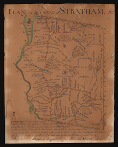
Plan of the Town of Stratham.
$25,000.00
Acquire
- Digital Map Information
- Suitable for large format printing
- File Size: 3.77 MB
- File Type: ZIP / TIFF
- ICC color profile embedded
- Delivered instantly via download link
An extraordinary discovery, this is Phinehas Merrill's 1792 original manuscript draft of his important Plan of the Town of Stratham, published a year later in 1793. Not only is this the first map of any New Hampshire town, it is a key example of early American mapmaking, comparable in many ways to Christopher Colles' 1789 Roads. Moreover, while the printed map is in and of itself significant - and rare, existing in just 12 known examples - this unprecedented example is Merrill's own working draft, drawn by his own hand and exhibiting signs of an evolving production. (more details)