This item has been sold, but you can get on the Waitlist to be notified if another example becomes available, or purchase a digital scan.
1864 Merrill Civil War Atlanta Campaign Cavalry Field Map of Northeastern Georgia
PartofNorthernGeorgia-merrill-1864$6,750.00

Title
Map of Northern Georgia.
1864 (dated) 22 x 15 in (55.88 x 38.1 cm) 1 : 253440
1864 (dated) 22 x 15 in (55.88 x 38.1 cm) 1 : 253440
Description
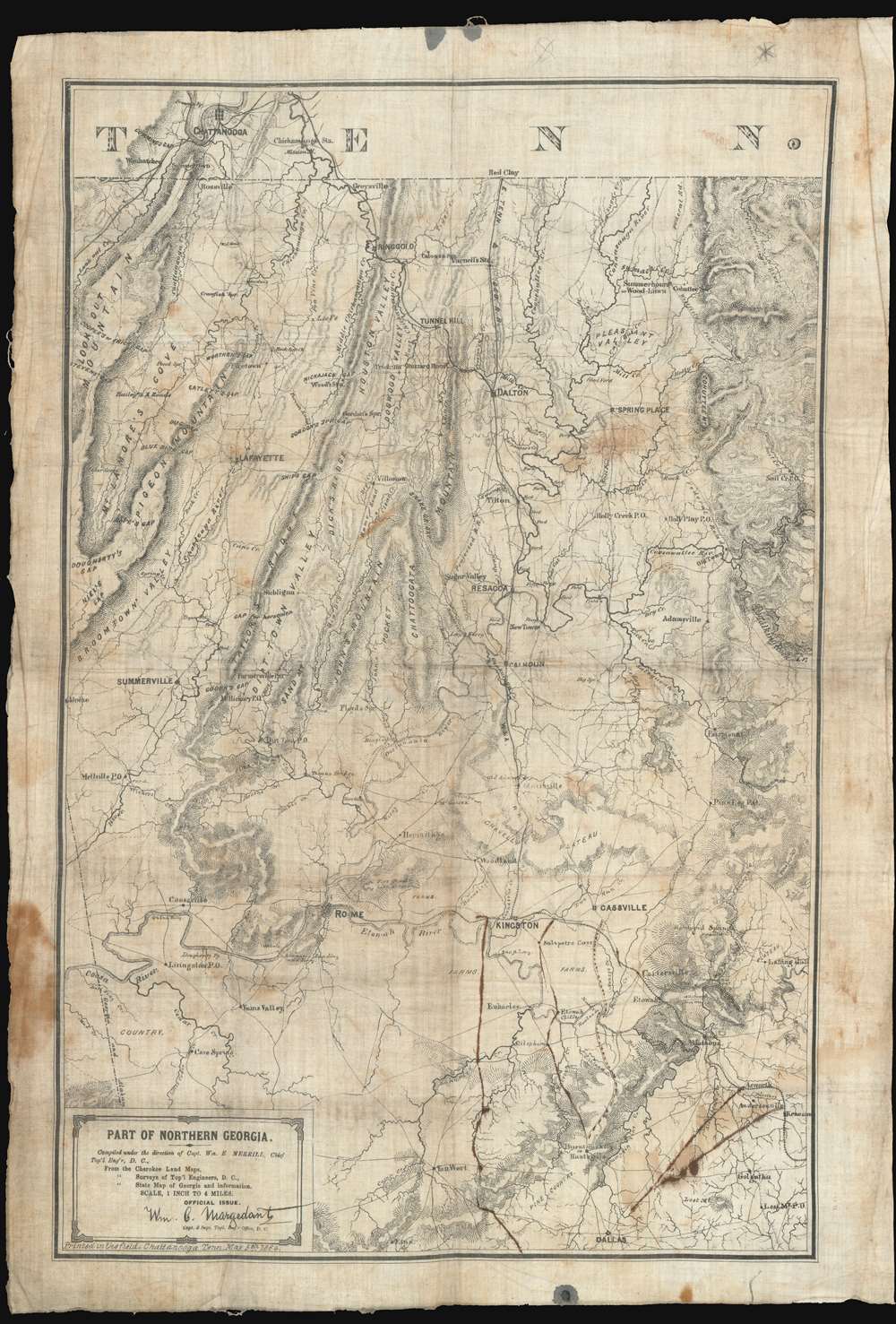
'Printed in the Field, Chattanooga, Tenn.', this map of northwestern Georgia is a remarkable artifact of the American Civil War (1861 - 1864) issued by William E. Merrill and William C. Margendant days before the launching of the Atlanta Campaign (May 7, 1863 - Sep 2, 1864). Printed on muslin specifically for Union Calvary officers, this map covers the northeastern part of Georgia, from Chattanooga and the Tennessee border south as far as Dallas and east to include Kennesaw. There can be little doubt that this map saw action in the field, with period manuscript annotations marking routes after May 17th, when Sherman split Union forces south of Adairsville into three separate armies headed by Maj. Generals John Schofield, George H. Thomas, and James B. McPherson.
After his defeat at Chickamauga (September 20, 1863), Rosecrans lost command of the Army of the Cumberland to General William Tecumseh Sherman. Like Rosecrans, Sherman well understood the value of cartographic reconnaissance, especially in light of the battle ahead. Sherman needed to push the war into Georgia and seize Atlanta. As this map brilliantly illustrates
Regarding scarcity. This map is exceedingly rare. We know that 200 examples of the larger map were printed for infantry generals and other high officers, so it can be safely assumed that these muslin maps were printed in far smaller numbers. Moreover, given the nature of their use in the field, it is likely that very few survived. Other than the present example, we are aware of two other examples of the map which are part of the collections at the Library of Congress and one at the New York Public Library. Other examples are cited in the OCLC, but further research indicates these are merely duplications of the LOC examples. No market history. A unique opportunity for the serious Civil War collector.
Calvary Officer's Muslin Maps
Merrill issued three maps on muslin for use by cavalry officers. The maps were all extracted from his May 2, 1864 Map of Northern Georgia. World Maps Online's article on Civil War field mapping provides this important explanation of the Atlanta Campaign linen maps:In addition to the standard edition of the campaign map lithographed on paper, it was also printed directly on muslin and issued in three parts. Van Horne points out that this was mainly for the convenience of the cavalry, 'as such maps could be washed clean whenever soiled and could not be injured by hard service.' Each section of the cloth map is entitled 'Part of Northern Georgia' and was printed from one of the lithographic stones used for the standard campaign map.The present map, occupying the most northeasterly part of Georgia, was likely the first such 'cavalry map' to be produced, as, unlike the others, it is dated, and does not feature the 'Part 2' or 'Part 3' designation. Moreover, as the Union Armies were marching south towards Atlanta from their base in Chattanooga, this would have been the first map required. The idea of printing maps in the field on muslin was novel and can be wholly attributed to Merrill's ingenuity. Mostly likely, this, the first of his muslin maps, was a successful experiment that he expanded upon with two subsequent maps.
- Part of Northern Georgia - present map - covers the northeastern part of Georgia, from Chattanooga and the Tennessee border south as far as Dallas and east to include Kennesaw.
- Part of Northern Georgia No. 2 - covers from Rome and Kingston south as far as Ashbury and Hogansville, and east to Campbellton just west of Atlanta.
- Part of Northern Georgia No. 3 - likely the last of the series to be produced, this map covers the area around Atlanta, from Gainesville in the north to Griffen, and from Marietta in the west to Covington.
Merrill's Mapping of Northern Georgia
William E. Merrill's mapping of Northern Georgia during the Civil War is a tour-de-force of military field cartography. Merrill was recruited by Union Maj. Gen. William S. Rosecrans, or 'Old Rosy,' to head the Army of the Cumberland's topographical engineers. By the time Union forces seized Chattanooga, Merrill had transformed the ragtag topographical engineers into streamlined field-mapping operation of the highest caliber, capable of compiling detailed maps and printing them using William C. Margedant’s quick process in a matter of days. Cartography and the Topographical Engineers became integral to the Army of the Cumberland’s strategic and tactical capability.After his defeat at Chickamauga (September 20, 1863), Rosecrans lost command of the Army of the Cumberland to General William Tecumseh Sherman. Like Rosecrans, Sherman well understood the value of cartographic reconnaissance, especially in light of the battle ahead. Sherman needed to push the war into Georgia and seize Atlanta. As this map brilliantly illustrates
The terrain between Chattanooga and Atlanta is a tangle of winding ridges, narrow passes, swift running rivers, rocky stream fords, and red clay farm roads - hardly ideal topography for an invading army of 100,000 men and 35,000 animals to traverse. (Veg, George, 'Sherman's Secret Weapon', in America’s Civil War November 2019).Merrill began his mapping with existing maps, including 1840s Cherokee Purchase plats, ' Surveys of Top'l Engineers, D.C.', and James R. Butt's Map of the State of Georgia. He compiled and revised these based upon field reports from reconnaissance units, spies, travelers, refugees, prisoner interrogations, itinerant preachers and peddlers, and more. Despite being in the field, Merrill was remarkably well equipped with
a printing press, two lithographic presses, one photographic establishment, arrangements for map-mounting, and a full corps of draughtsmen and assistants. (Van Horne, T., History of the Army of the Cumberland vol. II, 456)Again, according to Van Horne, 'The army that General Sherman led to Atlanta was the best supplied with maps of any that fought in the Civil War.'
The Atlanta Campaign
The Atlanta campaign was a series of battles fought in the Western Theater of the American Civil War (1861 - 1865) throughout northwest Georgia and the area around Atlanta during the summer of 1864. Union Maj. Gen. Beginning in May, William Tecumseh Sherman invaded Georgia from the vicinity of Chattanooga, Tennessee. He was opposed by Confederate generals Joseph E. Johnston and John Bell Hood. Atlanta, at the time, was an important Confederate railroad and supply center. With superior equipment, numbers, and forces, the Union Armies of the Ohio, Cumberland, and Tennessee steadily advanced south throughout the sweltering southern summer, ultimately capturing Atlanta on September 2, 1864. After the surrender of Atlanta, Sherman continued his offensive, embarking on his famous March to the Sea and ultimately capturing Savannah. The capture of Atlanta had significant political ramifications. Lincoln, a Republican who supported the war, was then up for re-election, running in a tight race against the Democrat George B. McClellan. McClellan ran on a peace platform and advocated a truce with the Confederacy. The victory at Atlanta, which was heavily celebrated by northern newspapers, significantly boosted Union morale and correspondingly Lincoln's campaign, causing him to be re-elected with a public mandate.The Manuscript Annotations
Contemporaneous markings denote the May 17th splitting of Sherman's main army into a flanking maneuver involving three axes of advance: A western arm comprised of Major General John Schofield's Army of Ohio, which progressed via Van Wert to Dallas, where they engaged on May 28th. An eastern arm comprising Major General George H. Thomas's Army of the Cumberland, which engaged on May 27th at Pickett's Mill. And a more direct central advance led by Major General James B. McPherson's Army of the Tennessee which engaged at New Hope Church on May 25th. Further manuscript notations appear to note Confederate entrenchment southeast of Cassville at Cass Station (Railroad stop) and between Acworth and Dallas, where the battles of Pickett's Mill (May 27), New Hope Church (May 25) and Dallas (May 28th) were fought. Near here as well, Andersonville, the site of the Confederacy's most notorious prison camp, is also noted.Publication History and Census
This map was printed in the Topographical Engineer offices of the Army of the Cumberland in Chattanooga, Tennessee on May 5, 1864, shortly before the Union advance into Georgia on May 7, 1864, known as the Atlanta Campaign. As noted above, the map is cartographically derived from Merrill's larger Map of Northern Georgia, printed on May 2. Unlike that large map, this map has been printed on muslin in smaller format, covering a smaller area on the same scale, thus practical for rapid deployment and use on horseback. It is most likely, that of the three muslin maps issued by Merrill, this is the first, as the route south of Chattanooga would be most immediately critical.Regarding scarcity. This map is exceedingly rare. We know that 200 examples of the larger map were printed for infantry generals and other high officers, so it can be safely assumed that these muslin maps were printed in far smaller numbers. Moreover, given the nature of their use in the field, it is likely that very few survived. Other than the present example, we are aware of two other examples of the map which are part of the collections at the Library of Congress and one at the New York Public Library. Other examples are cited in the OCLC, but further research indicates these are merely duplications of the LOC examples. No market history. A unique opportunity for the serious Civil War collector.
CartographerS
Phinehas Merrill (1767 - March 31, 1815) was an American educator, mathematician, surveyor and cartographer active in New Hampshire during the late 18th and early 19th century. Merrill was well known throughout New Hampshire as a surveyor. His survey work brought him to the attention of Philip Carrigain, then New Hampshire's Secretary of State. Carrigain was in the process of creating a large scale map of New Hampshire and Merrill surveying skills were essential to completing the project. Working together, Merrill and Carrigain completed numerous new surveys, check old surveys, and slowly pieced together a new monumental map of the state. The Carrigain Map of New Hampshire, as it came to be known, was completed in 1814, but not published until 1816, one year after Merrill's death. The devoted surveyor never saw his completed masterpiece. More by this mapmaker...
William C. Margedant (November 15, 1835 - January 12, 1900) was a German-American engineer and U.S. Army soldier. Born in Dusseldorf, Germany (then Prussia), Margedant was educated in Germany and immigrated to the United States in 1854. He settled in Cincinnati, Ohio, where he was employed by C.A. Latta and assisted in constructing the first steam fire engine in the United States. He then started working as a machinist in Hamilton, Ohio, in the shops of Owens, Lane, and Dyer and eventually began working for the Bentel and Margedant Company, which designed and manufactured wood working machinery. In 1861, Margedant volunteered to serve in the Union army and organized a company of forty-eight volunteers from Hamilton. This company then joined the Ninth Ohio Volunteer Infantry in Cincinnati and Margedant was elected captain of his unit. Margedant, after his first three month enlistment was up, was appointed to the topographical engineers on the staff of General William Starke Rosecrans (September 6, 1819 – March 11, 1898). He was involved in the organization and compilation of the first detailed topographic maps of West Virginia. While serving on Rosecrans's staff, Margedant
invented method of duplicating maps in the field by which all corps, divisions and brigades, as well as individual regiments when acting or moving alone, were furnished at each camp with maps of the surrounding country on the march, with those showing the roads, streams and other military features of country in advance. These maps were printed on cloth, often on a handkerchief and distributed in great numbers. Photographic duplications of charts gave valuable information as to camp grounds, water forage, kind of roads and trails and their condition. Every organization down to brigades had a topographical engineer whose business it was to gather daily all the information possible of the country where the troops halted, and of the region in advance, and reported it in the evening to the next superior headquarters. At army headquarters Capt. Margedant's force consolidated the topographical notes received, and the next day maps and charts containing everything ascertained the day before were in the hands of all commanding officers.Because of this service, Margedant came to be known as 'the pathfinder of the Army of the Cumberland.' Margedant then served on the staff of General John C. Fremont and saw combat in multiple battles. Margedant remained in the army until late 1864, when he fell seriously ill from typhoid fever. During his time in the army he participated in thirty-six battles and engagements, from West Virginia through the Shenandoah Valley, Tennessee, Georgia, and Alabama. Margedant remained active after the war, becoming a member of the Grand Army of the Republic and a staunch Republican. He was a figure in the community, a liberal giver of both time and money. He also served as the president of the Pioneers', Soldiers' and Sailors' Permanent Monument Association. Margedant married Caroline Son on January 28, 1864, with whom he had nine children. Learn More...
Army Corps of Topographical Engineers (fl.1838 - 1863) refers to the an elite branch of the U.S. Army created on July 4, 1838 to perform civil mapping and survey work throughout the United States. The origins of the Corps of Topographical Engineers can be traced back to the American Revolutionary War, where General George Washington recognized the need for accurate surveys pursuant to military action. Shortly following the war, in 1779, a civilian engineering corps was created by act of Congress. Identified in 1802 by Thomas Jefferson, the "Corps of Engineers," which was based at West Point, the group participated in the War of 1812 and in later in the fortification of New Orleans. It was not until 1838, however, that a separate group of "Topographical Engineers" was formally recognized. This elite group, consisting only of officers, most of whom were trained in surveying and engineering by the esteemed Andrew Ellicott at West Point, never numbered more than 36 individuals - the best and brightest. This small but determined group played a central role in the mapping and exploration of the American West. Few branches of the military can boast such a distinguished alumni. Their names resonate throughout the map of the west and include John Charles Fremont, Zebulon Pike, George Meade, Kemble Warren, William Amiel Weeks, A. B. Gray, Randolph B. Marcy, James H. Simpson, Howard Stansbury, John W. Gunnison, William Ludlow, and Robert S. Williamson. The onset of the American Civil War brought an abrupt end to the surveying activity of the Topographical Engineers. Many of the most prominent engineers went on to distinguished military careers on both sides of the War Between the States. The Army Corps of Topographical Engineers itself was folded into the Corps of Engineers on March 31, 1863. Though the Army Corps of Engineers continues to do military and civil survey work to this day, the elite club of adventures that formed the Topographical Engineers were no more. Learn More...
Condition
Good. Printed on muslin. Some staining. Old manuscript annotations relating to the Atlanta Campaign.
References
LC Civil War maps (2nd ed.), S31, S32. New York Public Library, Map Div. 15-414. OCLC 498131307.