
Norwood, Richard

Richard Norwood (c.1590 – 1675) was an English mathematician, diver, and surveyor. He has been called 'Bermuda’s outstanding genius of the seventeenth century'. He had been sent to Bermuda by the Bermuda Company, not initially to survey the islands but to harvest pearls. Norwood had devised an early form of diving bell, with which he had succeeded in retrieving a cannon from Lymington Harbor, England. The Company hoped to employ Norwood's device to harvest pearls from the oyster beds they believed surrounded the islands. When a wealth of pearls failed to materialize, the Company instead reassigned Norwood to survey the islands, and he executed several surveys between 1614 and 1617. These would provide the basis of the dominant printed images of Bermuda of the seventeenth century, first published by Speed in 1622 and copied by Blaeu and Hondius. Despite accusations of collusion with the governor to assign to the governor and himself eight shares of the best land in the islands, he retained a long association with the place. Although he held land patents in Virginia, he does not seem to have ever travelled there, remaining instead in the Bermudas until the 1630s. He primarily made his living at that time in London as a teacher of mathematics, but continued geographical work, producing for example a sophisticated survey of the route between London and York. Using observations of the sun at various latitudes, he produced the most accurate estimation of the length of a degree of the meridian that had ever been done in England: his work would be noted by Newton in his Principia Mathematica. During the English Civil War he returned to Bermuda, there to work underr a government grant as a schoolmaster. He is credited with founding Bermuda's oldest school, Warwick Academy, in 1662; that same year he produced a further survery of the islands. He died at Bermuda in 1675, aged about eighty-five.
Cartographic Design Genius - two maps, at different scales, superimposed upon one another.
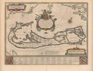
Mappa Aestivarvm Insularum, alias Barmudas.
$2,500.00
Acquire
- Digital Map Information
- Suitable for large format printing
- DPI: 600
- File Size: 51.37 MB
- File Type: ZIP / TIFF
- ICC color profile embedded
- Delivered instantly via download link
This is the classic 17th-century Dutch map of Bermuda: Willem Blaeu's map of the 'Summer Isles', here with superb old color. Engraved in 1630, Blaeu's version of Richard Norwood's chart is the most richly decorative to see print. Moreover, it is a marvel of cartographic design, in fact being two maps, on different scales, superimposed upon one another. (more details)
In Scarce Original Color.
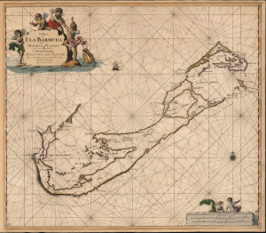
Pas Kaart van I. La Barmuda Anders Somer Islands int Groot Door Vooght Geometra.
$5,000.00
Acquire
- Digital Map Information
- Suitable for large format printing
- File Size: 24.21 MB
- File Type: ZIP / TIFF
- ICC color profile embedded
- Delivered instantly via download link
This is Johannes van Keulen's beautiful 1684 chart of Bermuda. This grand, desirable work is one of the earliest acquirable nautical charts of Bermuda; the present example is embellished with beautiful original color. (more details)