
Rawdon, Freeman

Freeman Rawdon (August 18, 1802 - September 21, 1859) was an American artist, engraver, and publisher. Born in Connecticut, Rawdon founded his engraving and printing firm sometime after 1825, likely in New York City. He partnered with Neziah Wright in 1828 and established Rawdon, Wright, and Company of New York City. Rawdon's brother Ralph Rawdon (December 19, 1793 - September 12, 1877) founded his own printing and engraving firm in Albany in 1816, and formed several partnerships between 1818 and 1832. The Rawdon brothers merged their firms on March 1, 1832, and formed Rawdon, Wright, Hatch, and Company. At the time of the merger, Tracy R. Edson joined the firm as its business administrator and ran the company's New Orleans office until 1847. He also played an outsize role in establishing the firm in Philadelphia, Cincinnati, and Boston. Edson was transferred to the New York City office in 1847 to run the entire firm. The company's name was changed to Rawdon, Wright, Hatch, and Edson. The firm won the U.S. government contract to print the first American postage stamps from 1847 - 1851. Rawdon, Wright, Hatch, and Edson merged with seven other firms in 1858 to form the American Bank Note Company.
The first map of Albany County.
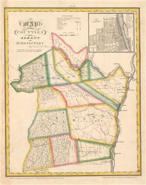
Map of the Counties of Albany and Schenectady.
$400.00
Acquire
- Digital Map Information
- Suitable for large format printing
- Full resolution TIFF file
- ICC color profile embedded
- Delivered instantly via download link
The first printed map of Albany County, this is David Burr's 1829 map of Albany and Schenectady Counties in New York. Towns in both counties are outlined in various colors to allow for easy differentiation and identified. Albany is situated along the Hudson River on the right. The region's stage roads are illustrated (although only the Mohawk Turnpike is labeled) and most of them serve Albany. Icons mark flour mills, factories, forges, sawmills, and churches. The Erie Canal runs through the upper portion of the map along the Hudson River from above Schenectady through West Troy and Washington to Albany. An inset of Albany appears in the upper right corner. Streets are illustrated and labeled. Eighteen locations across the city are numerically identified and correspond with an index in the upper right corner of the inset. These include the Capitol Building, the arsenal, and a dozen churches. (more details)
The Wine Country of the Southern Finger Lakes Region.
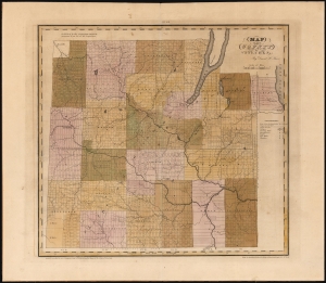
Map of the County of Steuben.
$400.00
Acquire
- Digital Map Information
- Suitable for large format printing
- DPI: 600
- File Size: 58.44 MB
- File Type: ZIP / TIFF
- ICC color profile embedded
- Delivered instantly via download link
This is David Burr's 1829 map of Steuben County, New York, south of the Finger Lakes region of western New York, along the Pennsylvania border. The county was part of Ontario County, which had been established in 1789 to administer the lands annexed by New York State in the Phelps and Gorham Purchase of 1788. By the time Burr produced this survey, the Purchase had passed through many changes, undergoing subdivisions into new counties as land was settled and populations grew. This process continued over the course of the 19th century within the new counties themselves, and the present map captures Steuben County during this process of transition, shown after the loss of land to Yates County in 1826 but before the 1854 formation of Schuyler County. (more details)