This item has been sold, but you can get on the Waitlist to be notified if another example becomes available, or purchase a digital scan.
1839 Burr Map of Otsego County, New York
OtsegoCounty-burr-1839$150.00

Title
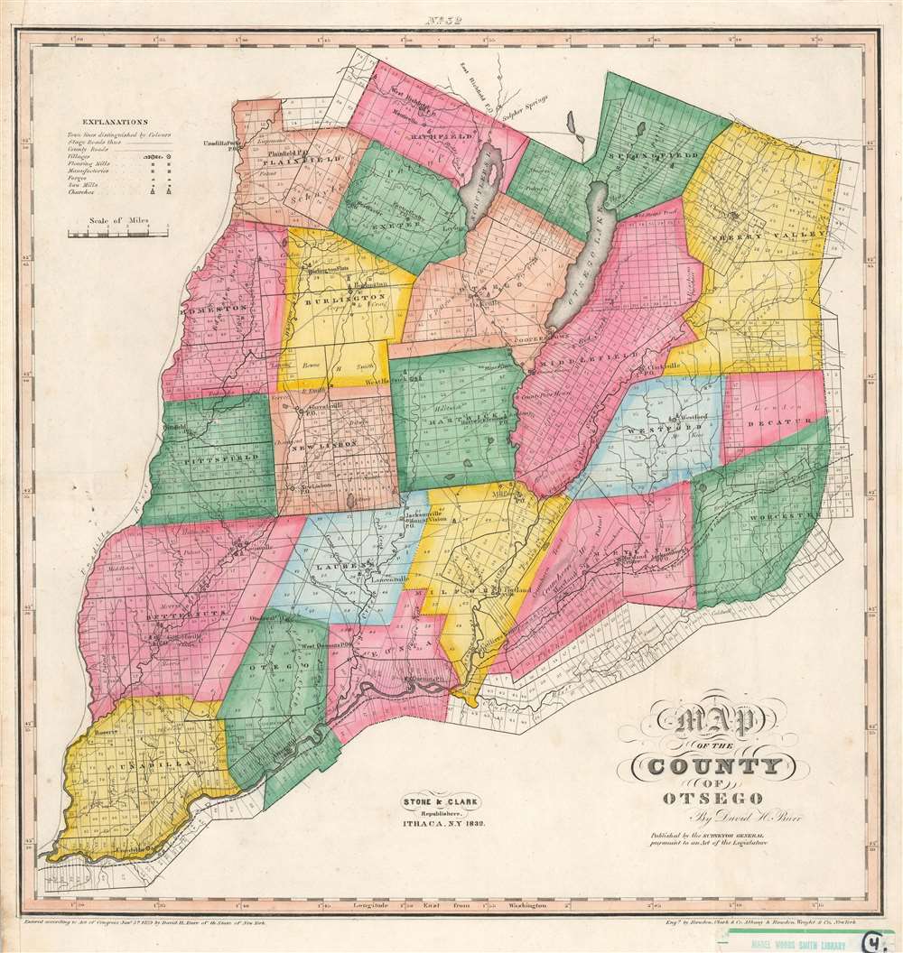
Map of the County of Otsego.
1839 (dated) 18 x 17 in (45.72 x 43.18 cm) 1 : 158400
1839 (dated) 18 x 17 in (45.72 x 43.18 cm) 1 : 158400
Description
This is an 1839 David Burr map of Otsego County, New York - including Cooperstown and vicinity. Individual townships are identified and shaded to allow for easy differentiation. Numerous private land claims are illustrated, some of which are identified by name. Churches (including the Hartwick Seminary), flouring mills, manufactories, forges, and sawmills are all marked. The county's lakes and rivers are illustrated and labeled, including Otsego Lake and Schuylers Lake. In one of Stone and Clark's updates to Burr's 1829 edition, the county's post offices, marked 'P.O.', are labeled.
Publication History and Census
This map was created by David H. Burr in 1829 and republished by Stone and Clark in 1839 (present example) in their edition of Burr's An Atlas of the State of New York…. This map is well represented institutionally.CartographerS
David Hugh Burr (August 18, 1803 - December 25, 1875) of one of the first and most important truly American cartographers and map publishers. Burr was born in Bridgeport Connecticut in August of 1803. In 1822 Burr moved to Kingsboro, New York to study law. A year and a half later he was admitted to the New York Bar association. Burr must have questioned his choice of careers because shortly after being admitted to the Bar, he joined the New York State Militia. Though largely untrained in the art of surveying, Burr was assigned to work under Surveyor General of New York, Simeon De Witt, to survey several New York Roadways. Seeing a window of opportunity, Burr was able to negotiate with the governor of New York at the time, De Witt Clinton, to obtain copies of other New York survey work in order to compile a map and Atlas of the state of New York. Recognizing the need for quality survey work of its territory, the government of New York heartily endorsed and financed Burr's efforts. The resulting 1829 Atlas of the State of New York was the second atlas of an individual U.S. state and one of the most important state atlases ever produced. Burr went on to issue other maps both of New York and of the United States in general. In cooperation with publishing firm of Illman & Pillbrow, he produced an important New Universal Atlas and, with J.H. Colton, several very important maps of New York City. In recognition of this work, Burr was appointed both "Topographer to the Post office" and "Geographer to the House of Representatives of the United States". Later, in 1855, Burr was assigned to the newly created position of Surveyor General to the State of Utah. Burr retired from the position and from cartographic work in general in 1857 when light of some of his financial misdeeds and frauds came to light. He was accused of submitting false expense reports and underpaying employees, among other indiscretions. More by this mapmaker...
Stone and Clark (fl. c. 1828 - 1855) was a publishing, engraving, and lithography firm based in Ithaca, New York. Very little of substance is known about the firm. The well known lithographer and painter, Henry Walton (1820 - 1873), worked for the firm from around 1836 until he moved to California in 1851. An advertisement in the September 11, 1839, edition of the Ithaca Chronicle placed by Stone and Clark reads that they, 'execute job work of any description, steel, copper-plate and wood engraving, letter press printing and book binding.' Around 1839 they acquired the printing rights to David Hugh Burr's (1803 - 1875) Atlas of the State of New York, which they published in at least two editions (1839 and 1840). Learn More...
Ralph Rawdon (December 19, 1793 - September 12, 1877) was an American engraver and printer. Born in Connecticut, Rawdon established his engraving and printing firm in Albany, New York, in 1816. He formed a partnership with Vistus batch of Willismtown, Massachusetts, in 1818 that lasted until 1822. He then formed Rawdon, Clark, and Company with Asahel Clark. Rawdon's brother, Freeman Rawdon (August 18, 1802 - September 21, 1859) founded his own engraving and printing firm in New York City sometime after 1825. Freeman Rawdon formed a partnership with Neziah Wright in 1828 and established Rawdon, Wright, and Company. The Rawdon brothers merged their firms on March 1, 1832, and formed Rawdon, Wright, Hatch, and Company. At the time of the merger, Tracy R. Edson joined the firm as its business administrator and ran the company's New Orleans office until 1847. He also played an outsize role in establishing the firm in Philadelphia, Cincinnati, and Boston. Edson was transferred to the New York City office in 1847 to run the entire firm. The company's name was changed to Rawdon, Wright, Hatch, and Edson. The firm won the U.S. government contract to print the first American postage stamps from 1847 - 1851. Rawdon, Wright, Hatch, and Edson merged with seven other firms in 1858 to form the American Bank Note Company. Ralph Rawdon is largely remembered for his role in the founding of the American Bank Note Company and little detail remains about his personal life. Learn More...
Freeman Rawdon (August 18, 1802 - September 21, 1859) was an American artist, engraver, and publisher. Born in Connecticut, Rawdon founded his engraving and printing firm sometime after 1825, likely in New York City. He partnered with Neziah Wright in 1828 and established Rawdon, Wright, and Company of New York City. Rawdon's brother Ralph Rawdon (December 19, 1793 - September 12, 1877) founded his own printing and engraving firm in Albany in 1816, and formed several partnerships between 1818 and 1832. The Rawdon brothers merged their firms on March 1, 1832, and formed Rawdon, Wright, Hatch, and Company. At the time of the merger, Tracy R. Edson joined the firm as its business administrator and ran the company's New Orleans office until 1847. He also played an outsize role in establishing the firm in Philadelphia, Cincinnati, and Boston. Edson was transferred to the New York City office in 1847 to run the entire firm. The company's name was changed to Rawdon, Wright, Hatch, and Edson. The firm won the U.S. government contract to print the first American postage stamps from 1847 - 1851. Rawdon, Wright, Hatch, and Edson merged with seven other firms in 1858 to form the American Bank Note Company. Learn More...
Source
Burr, D., An Atlas of the State of New York… (Ithaca: Stone and Clark) 1840.
The 1839/1840 Stone and Clark republication of David Burr's An Atlas of the States of New York provides an update to Burr's landmark 1829 work of American cartography. Stone and Clark detail the updates in a 'Supplementary Introduction'. The need for an updated edition arose from the founding of new cities and villages, along the with expansion of existing ones, along the with the construction of railroads, canals, and other public works. A new state census in 1835 also new information that needed to be incorporated. Peran article by Jo Margaret Mano, Stone and Clark sent 'competent individual(s) into each county (with a map of the same in his hand) with instructions to visit each town thereof, and to ascertain from citizens of thesame, everything of general interest.' One of the most apparent changes was the addition of post offices across the state. The 1840 edition also added 'points of historical interest' in a few counties, along with detailed descriptions and statistics concerning railroads and canals across the state. Again, per Mano, 'The maps themselves were updated to include new 'public improvements, institutions of learning, canals, railroads, turnpikes, harbors, lighthouses, etc.'
Condition
Very good. Left side remargined. Old collection stamp in lower right corner not effecting printed area. Blank on verso.
References
Rumsey 0105.084 (1840 edition). OCLC 29050020 (1840 edition).