
Renard, Louis

Louis Renard (1678 - 1746) was a Huguenot engraver and bookseller. Renard was born in France in 1678 and moved to the Netherlands in 1703. He acquired many of Frederick de Wit's map plates, which he consolidated with minor updates and revisions into the 1715, Atlas de la Navigation et du Commerce. From about 1706 Renard represented the interest of Guillaume De L'Isle in Holland, a relationship that ended on a sour note in 1718. Renard later sold the plates for the Atlas de la Navigation et du Commerce to R. and J. Ottens, who republished it under their own imprint in 1745.
Hercules holding up the world.
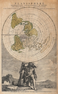
Planisphere representant toute l'etendue du monde dans l'ordre qu'on suivi dans ce livre.
$950.00
Acquire
- Digital Map Information
- Suitable for large format printing
- File Size: 12.12 MB
- File Type: ZIP / TIFF
- ICC color profile embedded
- Delivered instantly via download link
This is the 1715 Louis Renard map of the world on a polar projection. The map utilizes Jean-Dominique Cassini's ground-breaking work from the Paris Observatory and served at the frontispiece for Renard's Atlas de la navigation et du commerce qui se fait dans toutes les parties due monde. The frontis' interesting iconography substitutes Hercules for Atlas in supporting the world - the message being clear: 'out with the old, in with the new.' (more details)