
Sá da Bandeira, Bernardo de Sá Nogueira de Figueiredo

Bernardo de Sá Nogueira de Figueiredo, 1st Marquess de Sá da Bandeira (September 26, 1795 - January 6, 1876) was a Portuguese politician who served as Prime Minister of Portugal five times between 1836 and 1870. Born to a noble family in Santarém, he fought on the liberal side during the Liberal Wars (1828 - 1834), when he was injured and had to have his right arm amputated. Sá da Bandeira was a prominent abolitionist and worked to abolish slavery in Portugal's colonies. He was known as a workaholic and a prolific reader who took a special interest in Portugal's colonies in Africa. Thanks to his military experience, he had cartographic training and was committed to developing accurate maps of the African interior. He was deeply concerned about expanding British influence in Africa and in 1861 compiled multiple sources to produce the most accurate map of the Zambezi River to date, with the tacit intention of buttressing Portugal's claims to the interior. Three years later, he co-authored a similar map of the interior of Angola. (The dream of Portuguese colonial advocates at the time was a Portuguese 'band' across Africa connecting Angola and Mozambique.) The city of Lubango in Angola was named after him from 1923 until the end of the Portuguese colonial period.
Groundbreaking Map of the African Interior.
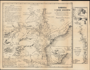
Zambezia e paizes adjacentes. Mappa coordenado sobre numerosos documentos, em que se comprehendem as viagens do Dr. Lacerda; Monteiro e Gamitto; Montanha e Teixeira; Green, Chapman e outros; e muito especialmente as do illustre Dr. Livingstone.
$1,200.00
Acquire
- Digital Map Information
- Suitable for large format printing
- Full resolution TIFF file
- ICC color profile embedded
- Delivered instantly via download link
A cartographic landmark in the European exploration of southeastern Africa, this is the rare 1867 second edition of the Marquess de Sá da Bandeira's groundbreaking map of the Zambezi River and its vast hinterland. The most comprehensive European mapping of the region then published, it synthesizes Portuguese colonial records, British geographical intelligence, indigenous place names, commercial routes, and accounts of exploration to chart the territory from Lake Nyasa and the Zambezi Valley south to the Limpopo River and inland toward the Kazembe and Lunda kingdoms. More than a record of geographical discovery, the map is also an instrument of imperial ambition, issued as Portugal sought to transform its tenuous coastal claims in Mozambique into meaningful control over the African interior amid the accelerating expansion of British influence in southern Africa. (more details)