1867 Sá da Bandeira Map of the Zambezi River and Environs
Zambezi-sadabandeira-1867$1,900.00
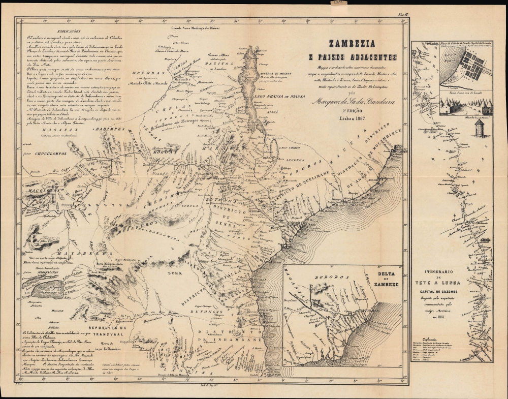

Title
Zambezia e paizes adjacentes. Mappa coordenado sobre numerosos documentos, em que se comprehendem as viagens do Dr. Lacerda; Monteiro e Gamitto; Montanha e Teixeira; Green, Chapman e outros; e muito especialmente as do illustre Dr. Livingstone.
1867 (dated) 17 x 22 in (43.18 x 55.88 cm) 1 : 3600000
1867 (dated) 17 x 22 in (43.18 x 55.88 cm) 1 : 3600000
Description
A scarce, groundbreaking work in the geographical understanding of southeastern Africa, this is the 1867 second edition of the Marquess de Sá da Bandeira's map of the Zambezi, the most comprehensive European map of this region at the time. Aside from its value for geographical information, the map was also motivated by increasing competition between Portugal and Britain in southern Africa.
Coverage includes a large portion of southeastern Africa between Lake Nyasa (Lake Malawi) in the north and Inhambane and the Limpopo River in the south, stretching from the East African coast inland to the Kafue (Cafue) River, a tributary of the Zambezi, now in southeastern Zambia, and the Gwayi (Quai) River, now in western Zimbabwe. Settlements, waterways, mountains, notes on local ethnic groups and leaders, administrative divisions, and other features are noted throughout. A detailed explanation at top-left discusses the best means of traveling up the Zambezi, with notes on landmarks, settlements, and navigation, with additional remarks along the same lines for the Inhambane District. At bottom-left, information is provided on Sofala, other ports, and import duties, as well as a list of abbreviations employed on the map. An inset map at bottom-right zooms in on the Zambezi Delta just south of Quelimane. As one of Africa's major rivers, the Zambezi has undergone important changes since this map was made, most notably the construction of two dams creating massive reservoirs, the Cahora Bassa in Mozambique and Lake Kariba on the border of Zambia and Zimbabwe.
At right, a map displays the itinerary of a Portuguese expedition undertaken in 1831 from Tete in Mozambique well into what is now Zambia, near the border with the modern-day Democratic Republic of the Congo. Oriented towards the northwest, the map highlights rivers, lakes, and other features encountered on the journey, as well as the territories of various peoples and kingdoms. The Kazembe (Cazembe) Kingdom was an offshoot of the Lunda Kingdom further west that was based around Lake Mweru, the Mofwe Lagoon (Lago Mofo), and the Luapula River. The capital called Lunda here is today Kanyembo, on the shores of the Mofwe Lagoon, which was later visited by David Livingstone during his travels through central Africa. At top-right is a plan of Lunda, described as 'two miles in extent' as well as illustrations of the city's main street and a typical house for the kingdom's nobility. A glossary at bottom-left gives Portuguese translations of local terms.
In the early-mid 19th century, the government launched a renewed effort to move colonists further inland and strengthen direct control over the interior. Once a rough understanding of the geography of the interior was obtained, some colonial advocates even dreamed of a unified string of Portuguese colonies and protectorates stretching across the continent from Angola to Mozambique. These efforts became more urgent as British interests in southern Africa rapidly expanded, beginning with explorers and missionaries, followed by traders, miners, diplomats, and, eventually, soldiers. At the time this map was made, these movements had not yet become a true colonial competition, but by the 1880s threatened military conflict between the two empires.
A Closer Look
This sheet includes two maps, the larger of which is Sá da Bandeira's meticulously researched map of the Zambezi. It is based on an 1861 edition (Zambezia e Sofálla: Mappa coordenado sobre numerosos documentos antiguos e modernos portuguezes e estrangeiros), which was the first detailed map of the Zambezi in its entirety. Though living in Portugal, Sá da Bandeira was a high-level member of the government with a deep interest in Portugal's African colonies, and he had collected and consulted all available Portuguese and British maps of the region to compile his own map. Moreover, this second edition includes significant new additions and updates.Coverage includes a large portion of southeastern Africa between Lake Nyasa (Lake Malawi) in the north and Inhambane and the Limpopo River in the south, stretching from the East African coast inland to the Kafue (Cafue) River, a tributary of the Zambezi, now in southeastern Zambia, and the Gwayi (Quai) River, now in western Zimbabwe. Settlements, waterways, mountains, notes on local ethnic groups and leaders, administrative divisions, and other features are noted throughout. A detailed explanation at top-left discusses the best means of traveling up the Zambezi, with notes on landmarks, settlements, and navigation, with additional remarks along the same lines for the Inhambane District. At bottom-left, information is provided on Sofala, other ports, and import duties, as well as a list of abbreviations employed on the map. An inset map at bottom-right zooms in on the Zambezi Delta just south of Quelimane. As one of Africa's major rivers, the Zambezi has undergone important changes since this map was made, most notably the construction of two dams creating massive reservoirs, the Cahora Bassa in Mozambique and Lake Kariba on the border of Zambia and Zimbabwe.
At right, a map displays the itinerary of a Portuguese expedition undertaken in 1831 from Tete in Mozambique well into what is now Zambia, near the border with the modern-day Democratic Republic of the Congo. Oriented towards the northwest, the map highlights rivers, lakes, and other features encountered on the journey, as well as the territories of various peoples and kingdoms. The Kazembe (Cazembe) Kingdom was an offshoot of the Lunda Kingdom further west that was based around Lake Mweru, the Mofwe Lagoon (Lago Mofo), and the Luapula River. The capital called Lunda here is today Kanyembo, on the shores of the Mofwe Lagoon, which was later visited by David Livingstone during his travels through central Africa. At top-right is a plan of Lunda, described as 'two miles in extent' as well as illustrations of the city's main street and a typical house for the kingdom's nobility. A glossary at bottom-left gives Portuguese translations of local terms.
Early Days of Anglo-Portuguese Competition in Southern Africa
In the early 19th century, Portugal was no longer a great world power, and its empire was significantly reduced, especially after the independence of Brazil in 1822. But the empire did still maintain a string of colonies, the largest of which were Angola and Mozambique. Some Portuguese had ventured into the African interior in the early days of their colonial presence and set up estates and trading post-garrisons, including at Sena (Senna) and Tete. Portuguese traders even went further inland, mostly along the banks of the Zambezi, into what is now Zambia and Zimbabwe, competing with established Swahili traders and seeking out gold, ivory, and slaves. However, settlers were few in number and generally intermarried with the local population to the point that they lost their Portuguese identity, while the estates were operated like independent fiefdoms rather than a shared colonial enterprise. The Portuguese inclination to try to force Christianity on their trading partners and use the presence of Muslim traders as an excuse for military campaigns also provoked opposition. Therefore, Portugal's control was mostly limited to coastal ports and most of the people it claimed to rule were effectively independent.In the early-mid 19th century, the government launched a renewed effort to move colonists further inland and strengthen direct control over the interior. Once a rough understanding of the geography of the interior was obtained, some colonial advocates even dreamed of a unified string of Portuguese colonies and protectorates stretching across the continent from Angola to Mozambique. These efforts became more urgent as British interests in southern Africa rapidly expanded, beginning with explorers and missionaries, followed by traders, miners, diplomats, and, eventually, soldiers. At the time this map was made, these movements had not yet become a true colonial competition, but by the 1880s threatened military conflict between the two empires.
Publication History and Census
This map was engraved by J.M.F. Palha and printed by the Imprensa Nacional in 1867. It was based on Sá da Bandeira's 1861 map of the Zambezi, which was then considerably updated, including the inclusion of the map at right. The meaning of the notation at top-right ('Est. II') and the linen tag attached to the top edge on the verso ('LXVI') are not clear. This edition of the map is quite rare, being held by four institutions: the British Library, the Biblioteca e Arquivo Histórico of the Portuguese Secretaria-Geral da Economia, the Archivo General de la Nación in Argentina, and the National Library of Brazil.CartographerS
Bernardo de Sá Nogueira de Figueiredo, 1st Marquess de Sá da Bandeira (September 26, 1795 - January 6, 1876) was a Portuguese politician who served as Prime Minister of Portugal five times between 1836 and 1870. Born to a noble family in Santarém, he fought on the liberal side during the Liberal Wars (1828 - 1834), when he was injured and had to have his right arm amputated. Sá da Bandeira was a prominent abolitionist and worked to abolish slavery in Portugal's colonies. He was known as a workaholic and a prolific reader who took a special interest in Portugal's colonies in Africa. Thanks to his military experience, he had cartographic training and was committed to developing accurate maps of the African interior. He was deeply concerned about expanding British influence in Africa and in 1861 compiled multiple sources to produce the most accurate map of the Zambezi River to date, with the tacit intention of buttressing Portugal's claims to the interior. Three years later, he co-authored a similar map of the interior of Angola. (The dream of Portuguese colonial advocates at the time was a Portuguese 'band' across Africa connecting Angola and Mozambique.) The city of Lubango in Angola was named after him from 1923 until the end of the Portuguese colonial period. More by this mapmaker...
Imprensa Nacional (1732 - present) is the national press of Portugal. Its origins lie in the Fábrica dos Caractéres, founded in 1732, which then merged with the Régia Oficina Tipográfica in 1768. In 1833, its name was changed to the Imprensa Nacional. The press publishes all manner of official government documents, from reports and maps to passports and stamps. In 1972, it merged with the national mint, the Casa da Moeda (dating to the 13th century), and was reformulated as a public corporation under the auspices of the Ministry of Finance. Learn More...
J. M. F. Palha (fl. c. 1863 – 1875) was a Portuguese cartographer and engraver who produced maps of Lisbon, Portugal, and Macau. Learn More...
Condition
Very good. Light wear on original folds.
References
OCLC 556302688, Archivo General de la Nación (Argentina) AR AGN AGN01-ADE-map-I039, Biblioteca Nacional (Brasil) ARC.024,08,015 - Cartografia, Biblioteca e Arquivo Histórico, Secretaria-Geral da Economia Call No. C 0011-21 B|BAHOP.