
Sanudo Marino Torsello (Sanuto)

Marino Sanudo (or Sanuto) Torsello (c. 1270 – 1343) was a Venetian statesman and geographer. He is best known for his efforts to instigate a new crusade to the Holy Land. This lifelong task resulted in his book, 'Liber Secretorum Fidelium Crucis (Book of Secrets for True Crusaders) which would be supplented by an array of the earliest surviving portolan charts of the Mediterranean coast and the Black Sea, executed by Pietro Vesconte. Sanudo was born to an aristocratic trading family in Venice around 1270; his father was a member of the Venetian Senate. In his youth Sanuto traveled broadly, visiting in time Acre, Greece, Romania, Palestine, Egypt, Armenia, Cyprus and Rhodes. He would eventually join the entourage of the Doge of Venice; after 1305 he attended Cardinal Riccardo Petroni in Rome.
He was a vigorous correspondent, particularly with travelers whose reach had extended beyond his own.
Perhaps related to his early experiences in Acre - which fell rapidly to Muslim forces shortly after his visit there - Sanuto was a lifelong advocate of a crusade to capture the Holy Lands for the west. While he was certainly not alone among such instigators, his emphasis on strategy, practical financial backing, and detailed modern cartography set his proposals apart. His long term approach - with a preparatory blockade of and capture of Egypt to secure the invasion's flank - was never implemented. Nevertheless his book, often revised and updated, would find its way into the hands of not only the Pope but also King Charles IV of France. At least eleven manuscript copies are known to survive. Its complement of maps by Vesconte are the earliest medieval maps intended for military purposes.
He was a vigorous correspondent, particularly with travelers whose reach had extended beyond his own.
Perhaps related to his early experiences in Acre - which fell rapidly to Muslim forces shortly after his visit there - Sanuto was a lifelong advocate of a crusade to capture the Holy Lands for the west. While he was certainly not alone among such instigators, his emphasis on strategy, practical financial backing, and detailed modern cartography set his proposals apart. His long term approach - with a preparatory blockade of and capture of Egypt to secure the invasion's flank - was never implemented. Nevertheless his book, often revised and updated, would find its way into the hands of not only the Pope but also King Charles IV of France. At least eleven manuscript copies are known to survive. Its complement of maps by Vesconte are the earliest medieval maps intended for military purposes.
AKA: Sanuto
A Medieval Holy Land.
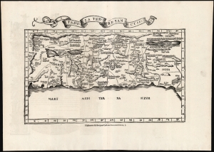
Tabula Terre Sanctae.
$2,250.00
Acquire
- Digital Map Information
- Suitable for large format printing
- Full resolution TIFF file
- ICC color profile embedded
- Delivered instantly via download link
This is the Lorenz Fries 1535 edition of Pietro Vesconte's 14th-century manuscript map of Palestine. It is one of the earliest obtainable iterations of a c. 1320 manuscript map compiled to accompany Marino Sanudo's letters promoting a new crusade. Thus, it is one of the earliest surviving maps to support a specific military effort. Relating to this, Vesconte's map was the earliest surviving map to present the region in a Biblical context, naming the areas occupied by the Tribes of Israel, thus opening a long history of presenting the Levant in a religio-historical context. (more details)
Earliest acquirable medieval plan of Jerusalem.
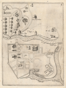
[Jerusalem.]
$2,000.00
Acquire
- Digital Map Information
- Suitable for large format printing
- Full resolution TIFF file
- ICC color profile embedded
- Delivered instantly via download link
This rare plan of Jerusalem is the earliest printed iteration of Pietro Vesconte's manuscript plan of the city. While not committed to print until this 1611 edition by Jacques Bongars, the map is the work of the 14th-century Venetian cartographer Vesconte, who produced it c. 1320 to promote Marino Sanudo's proposed crusade to recapture the city. As such, it is one of the earliest surviving plans to support a specific military effort. (more details)
Earliest printing of a Military Portolan of the Eastern Mediterranean.
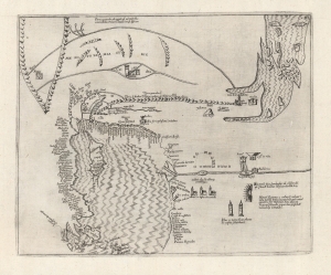
[Holy Land, Eastern Mediterranean, Egypt, Arabia and Mesopotamia.]
sold
- Digital Map Information
- Suitable for large format printing
- Full resolution TIFF file
- ICC color profile embedded
- Delivered instantly via download link
This is the earliest printed iteration of Pietro Vesconte's 1611 portolan map of the Eastern Mediterranean, the Lower Nile, the Arabian Peninsula, and Mesopotamia. While not committed to print until this 1611 edition by Jacques Bongars, the map is the work of the 14th-century Venetian cartographer Vesconte, who produced it c. 1320 to promote Marino Sanudo's proposed crusade. As such, it is one of the earliest surviving maps to support a specific military effort. (more details)
Medieval Acre, as a Hospitaller Stronghold.
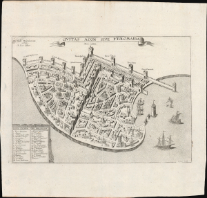
Civitas Acon Sive Ptolomaida.
$750.00
Acquire
- Digital Map Information
- Suitable for large format printing
- Full resolution TIFF file
- ICC color profile embedded
- Delivered instantly via download link
This is J. Picart's striking 1629 plan of the fortified city of Acre (in modern day Israel / Palestine), based on the c. 1320 manuscript plan of Pietro Vesconte: a depiction of the medieval port as a stronghold of the Knights Hospitaller in the Holy Land and the most important Crusader beachhead to the east. (more details)