
Schneider, Jean-François-Henri

Jean-François-Henri Schneider (December 1, 1851 - 1929/1930) was a French printer, publisher, and photographer active in French Indochina. The son of a French-German mason, Schneider fought as a volunteer during the 1870 Siege of Paris. He arrived in Saigon in 1882 after being recruited to work for the colonial government's printing office. The following year (1883) he was sent to Hanoi to create the Protectorate's printing house and he served as its first director. He resigned in 1885 and that year opened the very successful Imprimerie d'Extrême-Orient with his brother Ernest Hippolyte Schneider, the first private commercial printing house in Tonkin. They published from 1885 to about 1940 - surviving Schneider himself. In 1886, he bought the printing facility operated by the Protectorate Printing House and renamed the examined operation the Imprimerie Typographique de F.H. Schneider. In so doing, he also secured the contract to print all government papers, previously the pave of the Protectorate Printing House. Schneider established his own paper factory in 1891. He was also a passionate student of Vietnamese and formed great working relationships with local Vietnamese officials. He also edited dictionaries and other manuals in Vietnamese. He received the Legion of Honor in 1903. Schneider served as the director and editor if the Journal officiel de l'Indochine, founded the Revue indochinoise, and served as the director of L'Avenir du Tonkin.
Containing the Tonkin insurgency.
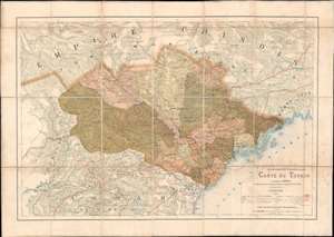
Indo-Chine Française Carte du Tonkin.
$1,000.00
Acquire
- Digital Map Information
- Suitable for large format printing
- File Size: 34.61 MB
- File Type: ZIP / TIFF
- ICC color profile embedded
- Delivered instantly via download link
This is an 1891 French Bureau topographique des Troupes de l'Indo-Chine map of Tonkin, Vietnam, Indochina. Depicting a region ravaged by war and still fighting against French occupation forces, the map was issued to provide the newly appointed governor-general of Indochina Jean-Marie de Lanessan, with a comprehensive view of Tonkin. Cities, towns, and villages are identified, and roads are illustrated throughout. (more details)
Novel adaptation of the optical telegraph to communicate typhoon data in the South China Sea.
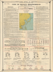
Code de Singauz Sémaphoriques (Typhons - Dépressions - Coups de Vent).
$1,800.00
Acquire
- Digital Map Information
- Suitable for large format printing
- File Size: 59.87 MB
- File Type: ZIP / TIFF
- ICC color profile embedded
- Delivered instantly via download link
This is a 1931 Observatoire Central de l'Indochine typhoon tracking map of East Asia - a wonder of early infographic weather mapping and data transmission. The map is an innovative guide to transmitting typhoon data gathered by remote weather monitoring stations with the central observatory at Phu Liên (northern Vietnam) via the Semaphore System or Optical Telegraph. (more details)