
Spilsbury, John

John Spilsbury (1739 – 1769) was a British cartographer, engraver, and bookseller. He is often credited as the inventor of the jigsaw puzzle. He apprenticed to Thomas Jefferys, the Royal Geographer to King George III. Spilsbury engraved maps for Andrew Dury and a number of charts for William Herbert. Spilsbury began producing dissected maps in 1766 as an educational tool to teach geography, pasting maps down to a board and then cutting them in pieces with a jigsaw.
Indian Ocean Pirate Utopia.
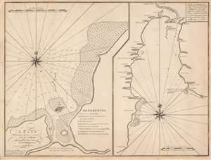
A Plan of the Principal Harbour and Town, of the Isl. S. Maries, Laying off the East Coast of the Isl. Madagascar in Lat. 17o. 00'S./ The Bay of Antongall on the N.E. part of the Island Madagascar.
$1,300.00
Acquire
- Digital Map Information
- Suitable for large format printing
- DPI: 600
- File Size: 45.88 MB
- File Type: ZIP / TIFF
- ICC color profile embedded
- Delivered instantly via download link
This is William Herbert’s rare 1767 chart illustrating Madagascar's most important northeast harbors: Ambodifotatra on Île Sainte-Marie, and Antongil Bay. Shortly before this chart was drawn, Île Sainte-Marie, was the site of the most famous and successful pirate utopia, and where Captain James Kidd's legendary galleon, the Adventure was scuttled. (more details)