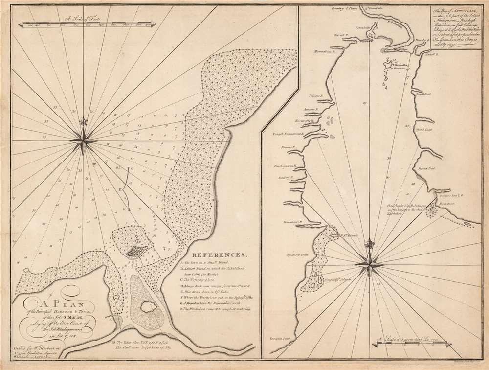
1767 Herbert Chart / Map of Pirate Havens Île Sainte-Marie and Antongil Bay, Madagascar
MadagascarHarbors-herbert-1767$1,300.00

Title
A Plan of the Principal Harbour and Town, of the Isl. S. Maries, Laying off the East Coast of the Isl. Madagascar in Lat. 17o. 00'S./ The Bay of Antongall on the N.E. part of the Island Madagascar.
1767 (undated) 17.5 x 23.25 in (44.45 x 59.055 cm) 1 : 7625
1767 (undated) 17.5 x 23.25 in (44.45 x 59.055 cm) 1 : 7625
Description
This is William Herbert’s rare 1767 chart illustrating Madagascar's most important northeast harbors: Ambodifotatra on Île Sainte-Marie, and Antongil Bay. Shortly before this chart was drawn, Île Sainte-Marie, was the site of the most famous and successful pirate utopia, and where Captain James Kidd's legendary galleon, the Adventure was scuttled.
The Île Sainte-Marie chart is centered on the island of Ilot Madame on the outskirts of Sainte-Marie's main town of Ambodifotatra. That island, at the mouth of the harbor, was home to a boisterous pirate town, here illustrated pictorially. The site is today the home of the Ilot Madame Museum of Pirate History.) The unnamed island in the middle of the bay is the île aux Forbans, haven of the age's greatest pirates: Adam Baldridge, William Kidd, Robert Culliford, Oliver Levasseur, Henry Every, Abraham Samuel, and Thomas Tew, among others.
Historical Context
By the time this chart was produced, the European navies had successfully blunted Indian Ocean piracy. Nonetheless, Madagascar's northeast harbors remained essential to mariners as watering places, resupply depots, and refuges against inclement weather. Although Madagascar was ruled by Merina Dynasty, that kingdom dominated the interior, allowing European powers free reign to maintain a continual if light coastal presence. After the pirates were cleared out in 1719, naval powers kept a keen watch on the area to deny its use to opposing powers, or future pirates.Île Sainte-Marie / Nosy Boraha
The left chart depicts the harbor of Île Sainte-Marie, known in Malagasy as Nosy Boraha. Both the French and English made several floundering attempts at settling the island in the 1640s. By the 1690s, Île Sainte-Marie became an infamous pirate utopia, a haven for British, French, and American pirates preying on the Indian Ocean trade and fleeing Caribbean pirate hunters.The Île Sainte-Marie chart is centered on the island of Ilot Madame on the outskirts of Sainte-Marie's main town of Ambodifotatra. That island, at the mouth of the harbor, was home to a boisterous pirate town, here illustrated pictorially. The site is today the home of the Ilot Madame Museum of Pirate History.) The unnamed island in the middle of the bay is the île aux Forbans, haven of the age's greatest pirates: Adam Baldridge, William Kidd, Robert Culliford, Oliver Levasseur, Henry Every, Abraham Samuel, and Thomas Tew, among others.
Antongil Bay
The right-hand chart focuses on Antongil Bay, the largest inlet along the coast of the main island of Madagascar, north of Île Sainte-Marie. Herbert’s source for this chart is not known, but it resembles contemporaneous charts by Bellin and other French chart makers. Antongil Bay's size and access to inland waterways made it an important refuge for both pirates and merchant mariners. The village at the northern tip of the bay is the modern-day town of Maroantsetra.Which Winchelsea?
A key of 'References' marks the town on Ilot Madame, a cattle market, watering place on the southeastern shore, and various navigational features. Some 'References' specifically refer to the Winchelsea. It is uncertain which particular Winchelsea this is. It has been speculated to be HMS Winchelsea, commanded in the 1760s by Captain Thomas Howe (1730 - 1771). Of this claim, we are skeptical. In 1759, HMS Winchelsea transported chartmaker Alexander Dalrymple from India to Malacca, and his 1775 chart (also derived from the 1746 Brohier manuscript) does not include the references to Winchelsea. It is unlikely that such would have been excised, should they have any relevance to his own cartographic work. It is more likely that the map refers to British East Indiaman Winchelsea, which plied the Indian Ocean from 1742 until its 1749 shipwreck near Fort St. David. It is there that the source chart's author, John Brohier, surfaces as a mariner in January 1750.John Brohier
The Île Sainte-Marie chart is derived from a 1746 manuscript by John Brohier. Brohier has long been an elusive figure. It is likely he was an engineer or apprentice on the East Indianman Winchelsea, and it is on that ship's visit to Madagascar that he drew the now lost manuscript - source for the present Herbert charts. When the Winchelsea shipwrecked in 1749 near Fort St. David, Brohier survived and sought refuge. He is recorded in East India Company dispatches as seeking sanctuary in January of 1750. Brohier went on to a significant if ignominious career as an EIC engineer, mapmaker, and ultimately, fraudster and fugitive.Improving British Navigation
Bookseller and publisher William Herbert spent his early years, from 1738 to 1745, at sea with the British East India Company. This experience left him with a distaste for existing nautical charts, and so upon establishing his London publishing firm he set out to produce a reliable, state-of-the-art replacement to Thornton's notoriously out of date English Pilot. To this end, he sourced charts by East India Company and Royal Navy officers, commercial navigators, and foreign sources to compile A New Directory for the East Indies. The first edition, published in 1758, contained thirty charts and subsequent editions grew with additional content. The third edition, published in 1767, brought the total to fifty-five. The The New Directory became a respected and desirable navigational resource during the crucial period of British expansion in the Indian Ocean. Even so, as a publication geared towards professional navigators, its distribution was extremely limited, with most being lost to the rigors of maritime use. All Herbert charts are thus very rare today.Publication History and Census
This is the first edition of the map, compiled and engraved by John Spilsbury for the 1767, third edition, of Herbert’s A New Directory for the East Indies. It is very rare. We see only one separate example in OCLC, listed by the Biblioteca Nacional de España, and we are aware of no examples appearing on the market since 2003.CartographerS
William Herbert (November 29, 1718 – March 18, 1795) was a British map seller, book seller, publisher, and surveyor based in London in the second half of the 18th century. Herbert was born in London, the son of a dyer and hosier of Gravel Lane. He signed on to the East India company in 1738 as a purser's clerk, traveling in the process to the colonies in India. He returned to London in about 1745, having amassed a considerable collection of manuscript plans and charts of East India ports. Recognizing their commercial value, he set up business as a map and print seller on London Bridge in 1748. The premises of this business were sadly destroyed while Herbed watched the April 11, 1759 London Fire. He published a number of maps as well as the important New Directory for the East Indies. Much of his most important cartographic work seem to be associated with William Nichelson, who traveled to the East Indies in the 1750s and 60s mapping ports on behalf of the EOC. He retired in 1776 in reasonable comfort. His publications continued to be updated and re-published by his successors, among them Samuel Dunn and Henry Gregory. More by this mapmaker...
John Brohier (fl. 1746 - 1760) was a British sailor, artilleryman, engineer, fraud, and fugitive from justice. The earliest record of Brohier is a 1746 manuscript chart of the harbor of Ambodifotatra on the island of Île Sainte-Marie, Madagascar. The chart references the anchorages used by the ship Winchelsea; this was most likely the Indiaman Winchelsea, which sailed for the EIC from 1742 until its wreck in April 1749 near Fort St. David (Bombay.) Apart from this chart, the name John Brohier first appears in East India Company dispatches - also, from Fort St. David - as a mariner, being permitted to reside in India beginning in January 1750. The next appearance of John Brohier is a request for appointment of a Lieutenant John Brohier, artilleryman, as assistant to Benjamin Robins, the Engineer General of the East India Company. No sooner was this request tendered than Robins died, and Brohier was appointed to carry out Robins' work on Fort St. George. From his death-bed, Robins had advised the Council, 'The Works here will be finished by Mr. Brohier, who has full instructions from me… He is certainly the properest Person for that Work I know and I recommend him as such. He has hitherto behaved, I believe, with great integrity.' Brohier went on to become Engineer-in-charge of all British territory in India, successfully improving the defenses of Fort St. David, Fort William, and Fort St. George over the course of the 1750s. In 1760, authorities in Calcutta reported that 'great Frauds (had been committed) in carrying out the new Works…' Brohier stood accused of having diverted a large amount of the funds allotted to the construction into his pockets. Arrested but then paroled, Brohier fled from Calcutta to Sri Lanka, which at the time was Dutch territory. It is supposed that he settled there, as he vanishes from the record. Learn More...
John Spilsbury (1739 – 1769) was a British cartographer, engraver, and bookseller. He is often credited as the inventor of the jigsaw puzzle. He apprenticed to Thomas Jefferys, the Royal Geographer to King George III. Spilsbury engraved maps for Andrew Dury and a number of charts for William Herbert. Spilsbury began producing dissected maps in 1766 as an educational tool to teach geography, pasting maps down to a board and then cutting them in pieces with a jigsaw. Learn More...
Source
Herbert, W., A new directory for the East-Indies:, (London: Gregory) 1767.
Condition
Good. Some reinstated areas of marginal loss, with some ms. replacement of border in upper corners. Else very good.
References
OCLC 431766327.