
Spiridon, Spyro N.

Spyro N. Spiridon (also spelled Spyridon) (1894 - 19xx) was a Jerusalem-born engineer and cartographer. Spiridon studied electrical and civil engineering in Switzerland in his twenties and was exposed to the types of pictorial tourist maps that were popular there. After returning to Jerusalem, Spiridon had difficulty making ends meet with jobs in his chosen field, so he changed tactics and created a pictorial tourist map of Jerusalem. Spiridon's first map, published in 1930, was one of the first tourist maps of Jerusalem to employ the vignette-style views of buildings to mark popular tourist sites. He then published a panorama of Jerusalem, with editions of this map appearing in 1945, 1948, and 1953 at the very least.
Mandatory Period Jerusalem.
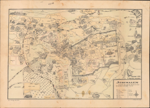
Jerusalem / Jerusalem Pictorial Plan.
$500.00
Acquire
- Digital Map Information
- Suitable for large format printing
- Full resolution TIFF file
- ICC color profile embedded
- Delivered instantly via download link
This is a scarce 1930 pictorial map of Jerusalem prepared by Spyro Spyridon and printed by Michael Pikovsky. The map depicts the city during the middle of the period of the British Mandate with handwritten annotations likely made by a member of the Irgun paramilitary group that date to the period when the city was besieged in May 1948 during the Arab-Israeli conflict. (more details)
Divisions and walls - ancient and modern.
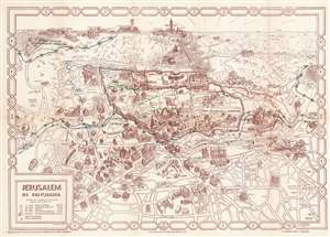
Jerusalem in Panorama.
$300.00
Acquire
- Digital Map Information
- Suitable for large format printing
- File Size: 21.56 MB
- File Type: ZIP / TIFF
- ICC color profile embedded
- Delivered instantly via download link
This is a 1953 Spyro Spiridon (Spyridon) pictorial map of Jerusalem. Spiridon's map illustrates sites across the city in profile, including schools, hospitals, churches, synagogues, hotels, and even the Y.M.C.A. The Dome of the Rock, the Wailing Wall, the Church of Dormition, and the Old City's walls are prominent. The Dead Sea appears along the upper right border. (more details)