
Taihoku Kozuka (台北小塚)

Taihoku Kozuka (台北小塚; fl. c. 1912 - c. 1945) was a Japanese operated Taipei publishing house, active from the early Taisho era, if not earlier. It merged with Books Sanseido (三省堂, an established Japanese bookstore still in operation in Japan) in 1941 and took the name Taiwan Sanseido Bookshop (台灣三省堂書店). Taihoku Kozuka regularly published maps and texts for the Colonial Governor's Office and other colonial offices, for example, School Handicraft and Drawing Teaching Guide (公學校手工及圖畫教授要目) in 1913 Taisho 2, Investigation of Han Nationality Townships in Taiwan (台灣在籍漢民族鄉貫別調查) in 1928 Showa 3, and Taiwan Social Enterprise Laws and Regulations (台灣社會事業關係法規) the same year.
AKA: 台北小塚
Planning the WWII Japanese invasion of British Malaya.
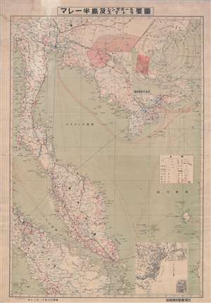
マレー半岛及スマトラシンガポール要圖 / [Malay Peninsula and Sumatra Singapore]
$1,500.00
Acquire
- Digital Map Information
- Suitable for large format printing
- File Size: 42.78 MB
- File Type: ZIP / TIFF
- ICC color profile embedded
- Delivered instantly via download link
This is a rare 1941 map of the Malay Peninsula, Sumatra, and Singapore, including portions of Thailand, British Burma, and French Indochina, printed in Taiwan for the Information (Intelligence) Department of the colonial Taiwan Governor's Office in Taipei. It was produced on November 30, 1941, less than two weeks before the Japanese invasion of British Malaya that coincided with the bombing of Pearl Harbor on December 7 (December 8 local time). Along with British Malaya and Singapore, the Dutch East Indies (Indonesia), the Philippines, and several other Western colonial possessions were invaded on or shortly after December 8. In the years and decades before this invasion, Taiwan had become an important node of information on 'South Seas' (Nanyō) Affairs, and served as a staging area for the invasion, including an intelligence gathering. The map includes two insets, one at top-right of the Greater East Asia Co-Prosperity Sphere (大東亜共栄圏) with Taiwan at the center and the area represented here shaded in red, and one at bottom-left of Singapore (シンガバール港). (more details)