
Information Bureau of the Tokyo Imperial University (東京帝國大學罹災者情報局)

Information Bureau of the Tokyo Imperial University (東京帝國大學罹災者情報局; fl. c. 1923 - 1924), more literally translated as Victims' Information Bureau of Tokyo Imperial University, was a temporary office set up in the wake of the Great Kanto Earthquake and fire that devastated Tokyo and nearby areas in September 1923. The information bureau produced a highly detailed map (帝都大震火災系統地圖 Map of the fire of Tokyo) and index charting the widespread fires and the winds that spread them following the earthquake itself.
AKA: 東京帝國大學罹災者情報局
How a wood and paper city burns.
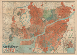
帝都大震火災系統地圖 / Map of the Fire of Tokyo.
$2,500.00
Acquire
- Digital Map Information
- Suitable for large format printing
- Full resolution TIFF file
- ICC color profile embedded
- Delivered instantly via download link
An exceptional example of an infographic masterpiece detailing the ignition and development of the Great Fire of Tokyo following the 1923 Great Kanto Earthquake. This partially bilingual 1923 map of the Great Tokyo Fire was issued by the Relief Information Bureau of Tokyo Imperial University just four months after the disaster. It focuses on ignition points and on the strong winds that coincided with the earthquake, which caused fire to spread rapidly and eventually burn down much of the dense wooden city. This example includes the original index, which we have never seen before, as well as its paper sleeve. (more details)