
Vesconte, Pietro

Pietro Vesconte (fl. 1310-1330) was a Genoese cartographer and geographer. His early portolan charts set the standard for such works produced in both Italy and Spain throughout the fourteenth and fifteenth centuries. Very little is known of his life. He was born in Genoa, but produced the bulk of his work in Venice. His charts - among the first of any to be signed and dated - remain among the earliest to accurately chart the coasts of the Mediterranean Sea and the Black Sea; his works contain some of the earliest attempts to chart the British Isles. In addition to his separate charts, he is known to have authored no fewer than four manuscript navigational 'atlases,' consisting of particular navigational charts that could be joined to make a larger, general one. His work was groundbreaking in its accuracy: the mappamundae that characterize this period were not characterized by precision, being more in the way of mnemonic aids for the study of the world by people unlikely to actually travel it. Many of his works, however, focused on the Holy Land, and these were produced in order to encourage a crusade to those regions.
A Medieval Holy Land.
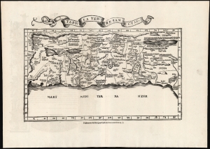
Tabula Terre Sanctae.
$2,250.00
Acquire
- Digital Map Information
- Suitable for large format printing
- Full resolution TIFF file
- ICC color profile embedded
- Delivered instantly via download link
This is the Lorenz Fries 1535 edition of Pietro Vesconte's 14th-century manuscript map of Palestine. It is one of the earliest obtainable iterations of a c. 1320 manuscript map compiled to accompany Marino Sanudo's letters promoting a new crusade. Thus, it is one of the earliest surviving maps to support a specific military effort. Relating to this, Vesconte's map was the earliest surviving map to present the region in a Biblical context, naming the areas occupied by the Tribes of Israel, thus opening a long history of presenting the Levant in a religio-historical context. (more details)
Earliest acquirable medieval plan of Jerusalem.
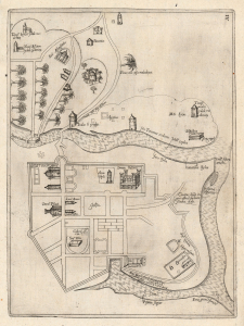
[Jerusalem.]
$2,000.00
Acquire
- Digital Map Information
- Suitable for large format printing
- Full resolution TIFF file
- ICC color profile embedded
- Delivered instantly via download link
This rare plan of Jerusalem is the earliest printed iteration of Pietro Vesconte's manuscript plan of the city. While not committed to print until this 1611 edition by Jacques Bongars, the map is the work of the 14th-century Venetian cartographer Vesconte, who produced it c. 1320 to promote Marino Sanudo's proposed crusade to recapture the city. As such, it is one of the earliest surviving plans to support a specific military effort. (more details)
Earliest printing of a Military Portolan of the Eastern Mediterranean.
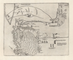
[Holy Land, Eastern Mediterranean, Egypt, Arabia and Mesopotamia.]
sold
- Digital Map Information
- Suitable for large format printing
- Full resolution TIFF file
- ICC color profile embedded
- Delivered instantly via download link
This is the earliest printed iteration of Pietro Vesconte's 1611 portolan map of the Eastern Mediterranean, the Lower Nile, the Arabian Peninsula, and Mesopotamia. While not committed to print until this 1611 edition by Jacques Bongars, the map is the work of the 14th-century Venetian cartographer Vesconte, who produced it c. 1320 to promote Marino Sanudo's proposed crusade. As such, it is one of the earliest surviving maps to support a specific military effort. (more details)
Medieval Acre, as a Hospitaller Stronghold.
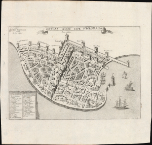
Civitas Acon Sive Ptolomaida.
$750.00
Acquire
- Digital Map Information
- Suitable for large format printing
- Full resolution TIFF file
- ICC color profile embedded
- Delivered instantly via download link
This is J. Picart's striking 1629 plan of the fortified city of Acre (in modern day Israel / Palestine), based on the c. 1320 manuscript plan of Pietro Vesconte: a depiction of the medieval port as a stronghold of the Knights Hospitaller in the Holy Land and the most important Crusader beachhead to the east. (more details)