
Alessandro della Via

Alessandro della Via (fl. 1680–1724) was a Veronese engraver and illustrator working in Venice. His cartographic work appears to have been entirely on behalf of Vincenzo Coronelli, in whose shop he was, by 1688. one of the most accomplished artists. It is certain that he executed the plates for the 1688 Venetian edition of Coronelli's 3 1/2 foot celestial globe, which Coronelli declared to be far superior to those executed by Jean Baptiste Nolin for the earlier Paris edition.
The Atlantic Islands, Real and Imagined, from the Finest Printed Globe of the 17th Century.
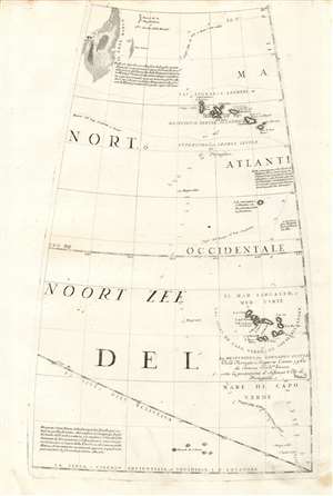
[Untitled Globe Gore of the Atlantic Ocean from the Equator to approximately 50º north].
$750.00
Acquire
- Digital Map Information
- Suitable for large format printing
- Full resolution TIFF file
- ICC color profile embedded
- Delivered instantly via download link
This scarce, beautiful engraving is a 1688 Coronelli globe gore map of the Atlantic Ocean from the Equator to 50° N, encompassing the Grand Banks, the Azores Islands, and the Cape Verde Islands. It was engraved in Vincenzo Coronelli's 42-inch (3 1/2 foot) terrestrial globe, reprinted in 1697 for inclusion in his Libro dei Globi and Isolario. In addition to the above locations, it includes near the equator an archipelago labeled 'Revedo de S. Pedro' which may represent the Atlantic island of Saint Paul. Among the other islands featured is the mythical paradise of St. Brendan. (more details)