This item has been sold, but you can get on the Waitlist to be notified if another example becomes available, or purchase a digital scan.
1688 / 1697 Coronelli Globe Gores of South America
SouthAmericaGores-coronelli-1693$3,000.00


Title
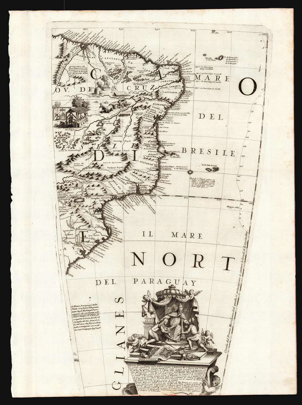
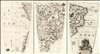
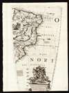
(Set of three Globe Gores of South America from the Equator to 50º south).
1693 (undated) 18.25 x 11 in (46.355 x 27.94 cm) 1 : 12500000
1693 (undated) 18.25 x 11 in (46.355 x 27.94 cm) 1 : 12500000
Description
This is a matched trio of globe gore sections covering most of South America, issued by Vincenzo Maria Coronelli in 1697. They are printed from the plates of Coronelli's 1688 3 1/2 foot Terrestrial globe. Coronelli considered the 1688 terrestrial and celestial globe pair to be his greatest work in print. He was not without justification: their superb engraving and encyclopedic geographic detail, not to mention their great size, set them easily amongst the finest globes produced in the 17th century. Desiring to display the quality of these works to a broader audience, and to challenge any potential competition, Coronelli published in 1697 a volume variously titled Libro dei Globi or Palestra Litteraria containing his globe gores (The title page bore a date of 1693, but the earliest known printing of the book was four years later.) 1697 was busy: Coronelli also included most of the gores from his terrestrial globe among conventional maps in his Atlante Veneto and Isolario that same year. In this case, less a product of the mapmaker's braggadocio and more a sensible reuse of expensively-produced copperplates.
The text below this scene begins by describing the division, via the treaty of Tordesillas, of the newly-discovered lands between Spain and Portugal under the authority of a succession of Popes starting in 1493 with Alexander VI. The second paragraph, on the other hand, details the events to which the cartouche is alluding. In January of 1680, the Portuguese King Peter II sent the governor of the Captaincy of Rio de Janeiro, Manuel Lobo, to take possession of the Spanish claimed island San Gabriel. He fortified the island and founded the village Colônia do Santíssimo Sacramento, just across the Rio de la Plata from Buenos Aires. He was insufficiently supported, and in August of that year the Spanish recaptured the island and imprisoned Lobo. A treaty between Spain and Portugal returned San Gabriel and Colonia to Portugal in 1681: unfortunately for Lobo it did not return him. He died in his Buenos Aires prison in 1683 at the age of 47.
Even at the time of production, globes were prohibitively expensive to produce and purchase in comparison with printed books. To compare, the 3 1/2 foot globe pair with stands cost 1240 Venetian Lire in 1697. The first volume of Coronelli's Atlante Veneto was 55.16 Lire. Therefore in order to reach a broader audience with his globes, and to get better return for the expense of producing the copperplate gores, Coronelli produced his Libro dei Globi which - though still tipping the scales at 310 Lire - would bring the magnificent engraving and detail of his work to those unwilling or unable to cough up twice as much for a single globe. It included the gores of all of Coronelli's globes - though a buyer hoping to construct the largest of these globes with the gores therein would have been sorely disappointed. The format of the book would not allow for the printing of the full-length gores of the 3 1/2 foot globe, which were therefore printed with portions masked off. Since this process did not change the plates, but merely obscured the parts which were not to be printed, it meant that different parts of the same gore could be chosen for different printings. This becomes significant when addressing the specific source of one or another of these bound gores, because many of the gores printed in the Libro dei Globi were focused differently than the same gores printed in Coronelli's 1697 Isolario. Indeed, it is extremely likely that different copies of the Libro dei Globi itself contained different maskings of the same gores. Studies of the book - of which there are but a dozen copies identified - show them to be made-to-order volumes with great variation in the inclusion of supplemental materials. No two are identical. And none of the books, it would appear, were intended to be full replacements for a globe: As Scianna points out:
The publication of the Libro dei Globi appears to have spanned both sides of the printing of the Isolario. A number of these - which seem to date as late as 1705 - bear the title Palestra Litteraria. This translates roughly to 'Literary Gymnasium' but Dr. Helen Wattis rendered it as 'Literary Wrestling Match' to capture the spirit in which the book was produced. Coronelli presented the work as a direct challenge to any cartographer, geographer, or astronomer to 'criticize or to compare with any other globe, the globes of Coronelli.' A modern rendition of 'Literary Throwdown' might not be amiss.
Geographical Contents
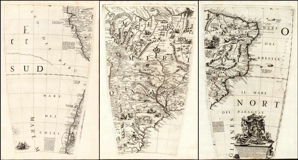
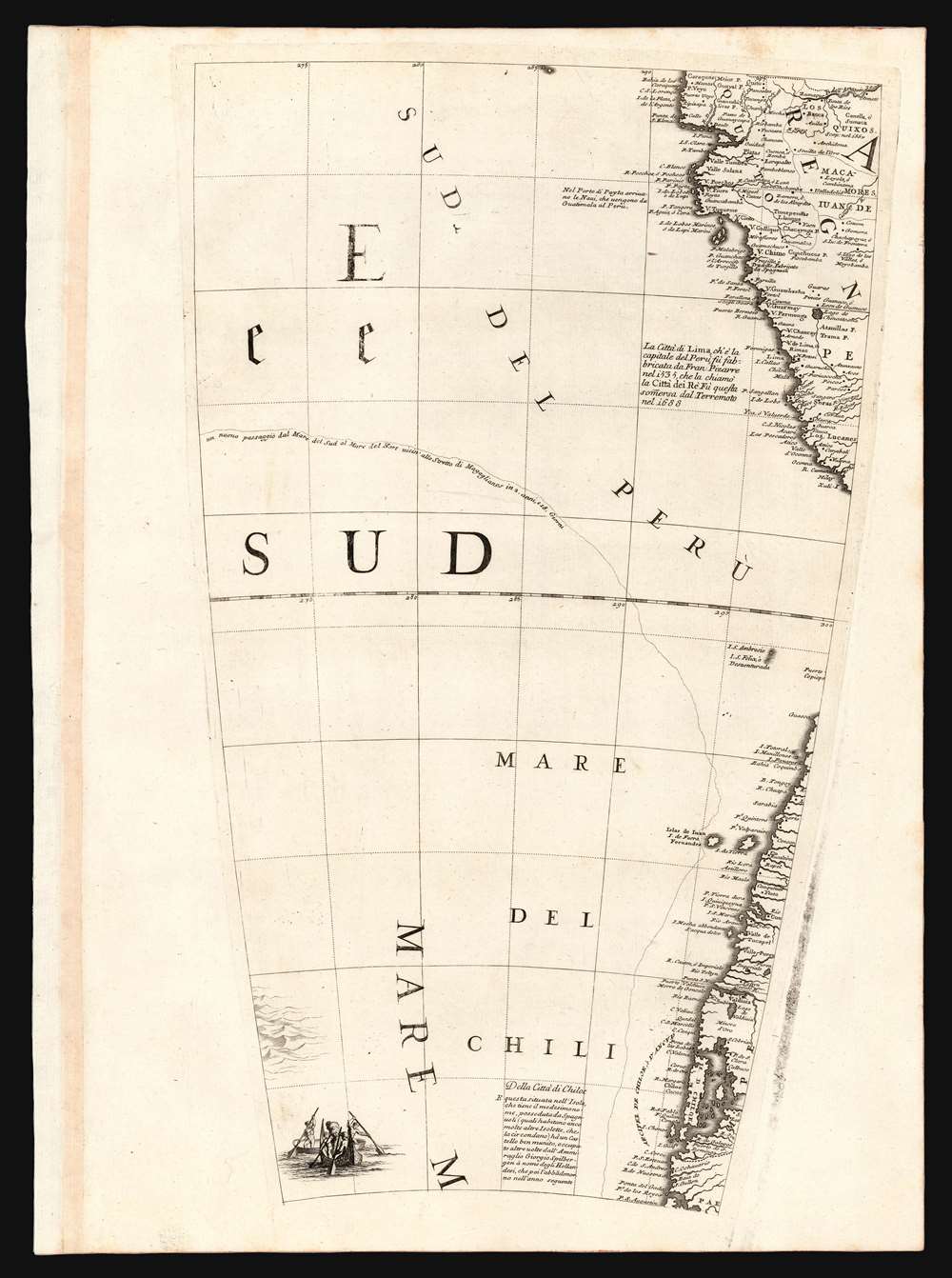
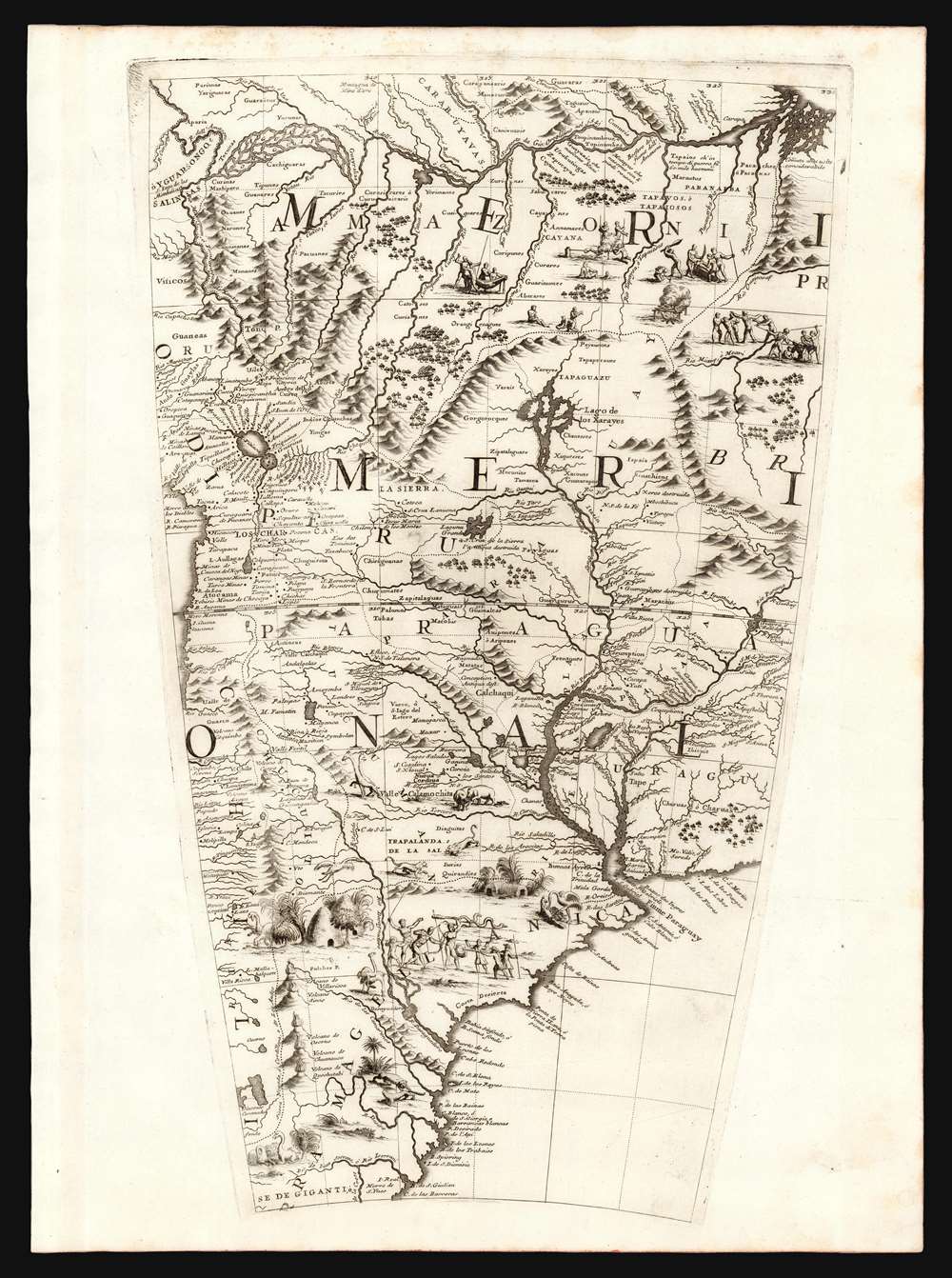
The three gores span from the equator to approximately 50º latitude south. They cover the Pacific coast of South America from the Bahia de Caraquez, Ecuador to the vicinity of the Gulf of Trinidad; and the Atlantic coast from the mouth of the Amazon to the vicinity of Puerto Santa Cruz in Argentina. The gores thus embrace modern day Brazil, most of Argentina, Chile, Uruguay, Paraguay, Peru, Bolivia, and most of Ecuador. The gores are replete with Coronelli's characteristically informative text descriptions. Magellan's track through the Pacific is shown, as is part of the 1685 track of Chaumont's embassy to Siam. The Amazon River is shown from an indeterminate source in Ecuador to its mouth, with a notation of its discovery in 1541 by Francisco de Orellana. The interior of South America reveals also the Rio de la Plata, and names the regions of Uruguay and Paraguay.Laguna de Xarayes
The mythical Laguna de Xarayes is illustrated here as the northern terminus, or source, of the Paraguay River. The Xarayes, a corruption of 'Xaraies' meaning 'Masters of the River', were an indigenous people occupying what are today parts of Brazil's Matte Grosso and the Pantanal. When Spanish and Portuguese explorers first navigated up the Paraguay River, as always in search of El Dorado, they encountered the vast Pantanal flood plain at the height of its annual inundation. Understandably misinterpreting the flood plain as a gigantic inland sea, they named it after the local inhabitants, the Xaraies. The Laguna de los Xarayes almost immediately began to appear on early maps of the region and, at the same time, to take on a legendary quality. Later missionaries and chroniclers, particularly Díaz de Guzman, imagined an island in this lake and curiously identified it as an 'Island of Paradise,'...an island [of the Paraguay River] more than ten leagues [56 km] long, two or three [11-16 km] wide. A very mild land rich in a thousand types of wild fruit, among them grapes, pears and olives: the Indians created plantations throughout, and throughout the year sow and reap with no difference in winter or summer, ... the Indians of that island are of good will and are friends to the Spaniards; Orejón they call them, and they have their ears pierced with wheels of wood ... which occupy the entire hole. They live in round houses, not as a village, but each apart though keep up with each other in much peace and friendship. They called of old this island Land of Paradise for its abundance and wonderful qualities.The mountains forming the spine of the west coast of South America are shown peppered with dramatically-engraved volcanoes. Rivers and colonial settlements are shown in detail, reflecting Coronelli's strong connection with Jesuit sources worldwide. Areas lacking in concrete detail for the interior are not left empty: the map is abundantly decorated with depictions of natives, both alone and in conflict with Europeans. These include an array of fearsome cannibal scenes in central South America, as well as scenes of sugar plantations nearer the coast. There are also many depictions of South America's exotic wildlife ranging from reasonably accurate portrayals of waterfowl and jaguars, and somewhat more imprecise renditions of llamas (some of which appear to have beaks).
The Cartouche
The cartouche - the work of the masterful Augsburg engraver Filipp Kilian - shows a Pope interceding between two armored cavaliers: from the arms displayed on their downcast shields, the remonstrating pair can be identified as representations of Spain and Portugal. At their feet between their discarded shields, helmets and swords, is the plan of a fortification bearing the date 1680 and labeled 'Forte S. Gabriele'. It is not clear the Pontiff's attitude is benignly paternal or more forceful: he appears to have at least Spain by the scruff of the neck. Putti flit about the scene - three making themselves useful with the drapes and sweeping up, while two to the left appear to be swept up in the spirit of brotherly love.The text below this scene begins by describing the division, via the treaty of Tordesillas, of the newly-discovered lands between Spain and Portugal under the authority of a succession of Popes starting in 1493 with Alexander VI. The second paragraph, on the other hand, details the events to which the cartouche is alluding. In January of 1680, the Portuguese King Peter II sent the governor of the Captaincy of Rio de Janeiro, Manuel Lobo, to take possession of the Spanish claimed island San Gabriel. He fortified the island and founded the village Colônia do Santíssimo Sacramento, just across the Rio de la Plata from Buenos Aires. He was insufficiently supported, and in August of that year the Spanish recaptured the island and imprisoned Lobo. A treaty between Spain and Portugal returned San Gabriel and Colonia to Portugal in 1681: unfortunately for Lobo it did not return him. He died in his Buenos Aires prison in 1683 at the age of 47.
Coronelli's 1688 globe, the Libro Dei Globi and other publications
Coronelli firmly established his reputation as a globe maker in 1683 when he created an astonishing pair of enormous manuscript globes for Louis XIV of France. These measured fifteen feet in diameter and were the largest globes produced to date. (The King declared these to be 'not the least of his ornaments' in Versailles). Basking in his success - for which he was awarded a fifteen-year privilege - Coronelli was quick to produce a printed 3 1/2 foot terrestrial and celestial globe pair for sale to the public. In 1686 he contracted with the French engraver Jean Baptiste Nolin to produce the celestial globe, and several geographical maps. This publication of work through Paris expanded Coronelli's reach as a map publisher and provided the basis for much of his early cartographic output. The terrestrial globe to accompany the celestial, was not executed in Paris but in Venice, where Coronelli was able to attract some of the eras finest artists. Augsburg engraver Filipp Kilian provided masterful work on the cartouches. Most of the engraving of the globe was assigned to Alessandro della Via, whose work on the Venice edition of the 1688 celestial globe Coronelli declared superior to that of the Nolin. Shirley enthused:The engraving and design throughout is of the highest standard with neat contrasting lettering and five large cartouches of singular grace and elegance... Coronelli seems to have sought to omit nothing that might be of interest to geographers, navigators, and explorers. There are an unusual number of legends, all explanatory and informative, but which never crowd the space available. Many of the vignettes of ships and fishing scenes throughout the world are worthy of separate reproduction.Complete sets of these gores are to be found in the British Library and the Library of Congress: they are of extraordinary rarity.
Even at the time of production, globes were prohibitively expensive to produce and purchase in comparison with printed books. To compare, the 3 1/2 foot globe pair with stands cost 1240 Venetian Lire in 1697. The first volume of Coronelli's Atlante Veneto was 55.16 Lire. Therefore in order to reach a broader audience with his globes, and to get better return for the expense of producing the copperplate gores, Coronelli produced his Libro dei Globi which - though still tipping the scales at 310 Lire - would bring the magnificent engraving and detail of his work to those unwilling or unable to cough up twice as much for a single globe. It included the gores of all of Coronelli's globes - though a buyer hoping to construct the largest of these globes with the gores therein would have been sorely disappointed. The format of the book would not allow for the printing of the full-length gores of the 3 1/2 foot globe, which were therefore printed with portions masked off. Since this process did not change the plates, but merely obscured the parts which were not to be printed, it meant that different parts of the same gore could be chosen for different printings. This becomes significant when addressing the specific source of one or another of these bound gores, because many of the gores printed in the Libro dei Globi were focused differently than the same gores printed in Coronelli's 1697 Isolario. Indeed, it is extremely likely that different copies of the Libro dei Globi itself contained different maskings of the same gores. Studies of the book - of which there are but a dozen copies identified - show them to be made-to-order volumes with great variation in the inclusion of supplemental materials. No two are identical. And none of the books, it would appear, were intended to be full replacements for a globe: As Scianna points out:
If Coronelli really wanted to collect all the prints he used for the gores of his globes in a single book, he would have to realize a volume of 180-184 plates, whereas no copy has that many. The most extensive copy is the one kept in Yale that has 167 plates; therefore even in this copy several plates are omitted.As alluded to above, Coronelli's Isolario, descrizione geografico-historia would see the mapmaker again employing the terrestrial globe gores - again, not as a representation of a complete globe, but as illustrative maps in a broader geographical text accompanied by conventional maps, views, and diagrams. The plates for the globe were approximately six inches too long to fit the format in which his books would be printed, so for the books Coronelli had the plates masked off at one end or the other to restrict the printed image to the half-folio sheets, and occasionally even smaller portions for insertion to the text. For most of the gores, Coronelli chose to mask the portions closest to the poles and to have the sheets centered on the tropics. In specific cases, he instead chose to present the areas ending at the Arctic or Antarctic circles, generally when there were features he wished to highlight: Hudson's Bay, for example, or Tierra del Fuego.
The publication of the Libro dei Globi appears to have spanned both sides of the printing of the Isolario. A number of these - which seem to date as late as 1705 - bear the title Palestra Litteraria. This translates roughly to 'Literary Gymnasium' but Dr. Helen Wattis rendered it as 'Literary Wrestling Match' to capture the spirit in which the book was produced. Coronelli presented the work as a direct challenge to any cartographer, geographer, or astronomer to 'criticize or to compare with any other globe, the globes of Coronelli.' A modern rendition of 'Literary Throwdown' might not be amiss.
Publication History and Census
The engraving seen in these gores was executed in 1688, to be assembled into Coronelli's 3 1/2 foot terrestrial globe. The present examples were not intended to be constructed into a globe, but were masked off for inclusion in one of Coronelli's bound volumes. Since the cardboard masks used in this process were movable, it was possible for Coronelli to change the parts of a gore that would be thus presented and so there is occasional variation in the globe gores that have survived. The 1969 Facsimile of the 1701 edition of the Libro Dei Globi includes all three of these gores centered on the Tropic of Capricorn as well as all three corresponding sheets spanning from the Antarctic circle to just north of the Tropic. Examples of the Isolariowe have examined do not contain all six sheets: rather, the first and third sheets are oriented on the tropic of Capricorn while the center's southern limit is the Antarctic Circle. Therefore, we believe these three sheets -consistently centered on the Tropic - to have come from an iteration of the 1697 Libro dei Globi. Their identical sheet sizes and red edging encourage us that they originated in the same volume. We are aware of one comparable set catalogued as part of the Banks collection at McMaster University. Scianna has catalogued only thirteen copies of the full volume in institutional and private collections.CartographerS
Vincenzo Maria Coronelli (August 16, 1650 - December 9, 1718) was an important 17th-century cartographer and globe maker based in Venice. Coronelli was born the fifth child of a Venetian tailor. Unlikely to inherit his father's business, he instead apprenticed in Ravenna to a woodcut artist. Around 1663, Coronelli joined the Franciscan Order and, in 1671, entered the Venetian convent of Saint Maria Gloriosa dei Frari. Coronelli excelled in the fields of cosmography, mathematics, and geography. Although his works include the phenomenal Atlante Veneto and Corso Geografico, Coronelli is best known for his globes. In 1678, Coronelli was commissioned to make his first major globes by Ranuccio II Farnese, Duke of Parma. Each superbly engraved globe was five feet in diameter. Louis IV of France, having heard of the magnificent Parma globes, invited Coronelli to Paris, where from 1681-83 he constructed an even more impressive pair of globes measuring over 12 feet in diameter and weighing 2 tons each. The globes earned him the patronage of Louis XIV and privileged access to French cartographic information from Jesuit sources in the New World, particularly Louisiana. Coronelli returned to Venice and continued to publish globes, maps, and atlases, which were admired all over Europe for their beauty, accuracy, and detail. He had a particular fascination for the Great Lakes region, and his early maps of this area were unsurpassed in accuracy for nearly 100 years after their initial publication. He is also well known for his groundbreaking publication of the first accurate map depicting the sources of the Blue Nile. At the height of his career, Coronelli founded the world's first geographical society, the Accademia Cosmografica degli Argonauti, and was awarded the official title Cosmographer of the Republic of Venice. In 1699, in recognition of his extraordinary accomplishment and scholarship, Coronelli was also appointed Father General of the Franciscan Order. The great cartographer and globe maker died in Venice at the age of 68. His extraordinary globes can be seen today at the Bibliothèque Nationale François Mitterrand in Paris, Biblioteca Marciana in Venice, the National Library of Austria, the Globe Museum in Vienna, the Library of Stift Melk, the Special Collections Library of Texas Tech University, as well as lesser works in Trier, Prague, London, and Washington D.C. Coronelli's work is notable for its distinctive style, which is characterized by the high-quality white paper, dark intense impressions, detailed renderings of topographical features in profile, and numerous cartographic innovations. More by this mapmaker...
Alessandro della Via (fl. 1680–1724) was a Veronese engraver and illustrator working in Venice. His cartographic work appears to have been entirely on behalf of Vincenzo Coronelli, in whose shop he was, by 1688. one of the most accomplished artists. It is certain that he executed the plates for the 1688 Venetian edition of Coronelli's 3 1/2 foot celestial globe, which Coronelli declared to be far superior to those executed by Jean Baptiste Nolin for the earlier Paris edition. Learn More...
Philipp Kilian (1628 - 1693) was a German engraver in the baroque style. He engraved the illustrations for Joachim von Sandrart'sTeutsche Academie. He made engravings for Barent Graat, and after paintings by Karel Skreta, Philippe de Champaigne, and Johann Carl Loth. He was among the engravers attracted to Venice to participate in the great work of Vincenzo Maria Coronelli, in 1688 executing the superb cartouches for the mapmaker's masterpiece 3 1/2 foot terrestrial globe. Learn More...
Source
Coronelli, V., Libro dei Globi, (Venice) 1693.
Coronelli firmly established his reputation as a globe maker in 1683 when he created an astonishing pair of enormous manuscript globes for Louis XIV of France. These measured fifteen feet in diameter and were the largest globes produced to date. (The King declared these to be 'not the least of his ornaments' in Versailles.) Basking in his success - for which he was awarded a fifteen-year privilege - Coronelli was quick to produce a printed 3 1/2 foot terrestrial and celestial globe pair for sale to the public. The 1688 globes were the largest printed globes to date, and Coronelli considered them to be his greatest work in print. He was not without justification. Their superb engraving and encyclopedic geographic detail, not to mention their great size, set them easily amongst the finest globes produced in the 17th century. Desiring to display the quality of these works to a broader audience, and to challenge any potential competition, Coronelli published in 1697 a volume variously titled Libro dei Globi or Palestra Litteraria containing his globe gores. (The title page bore a date of 1693, but the earliest known printing of the book was four years later.) 1697 was busy: Coronelli also included most of the gores from his terrestrial globe among conventional maps in his Atlante Veneto and Isolario that same year. The Libro dei Globi presented the gores of the globes as completely as possible, resulting in considerable overlap but allowing the gores to be viewed consecutively, highlighting their execution as a single work. The gores were employed in the Atlante Veneto as conventional maps. They accompanied the text of the volume, were not shown consecutively, and were not intended to be viewed as a whole. In 1686 Coronelli had contracted with the French engraver Jean Baptiste Nolin to produce an edition of the 3 1/2 foot celestial globe, and several geographical maps. This publication of work through Paris expanded Coronelli's reach as a map publisher and provided the basis for much of his early cartographic output. The terrestrial globe to accompany the celestial was not executed in Paris but in Venice, where Coronelli was able to attract some of the era's finest artists. Augsburg engraver Filipp Kilian provided masterful work on the cartouches. Most of the engraving of the globe was assigned to Alessandro della Via, whose work on the Venice edition of the 1688 celestial globe Coronelli declared superior to that of the Nolin. Shirley enthused:
Even at the time of production, globes were prohibitively expensive to produce and purchase in comparison with printed books. To compare, the 3 1/2 foot globe pair with stands cost 1240 Venetian Lire in 1697. The first volume of Coronelli's Atlante Veneto was 55.16 Lire. Therefore in order to reach a broader audience with his globes, and to get better return for the expense of producing the copperplate gores, Coronelli produced his Libro dei Globi which - though still tipping the scales at 310 Lire - would bring the magnificent engraving and detail of his work to those unwilling or unable to cough up twice as much for a single globe. It included the gores of all of Coronelli's globes - though a buyer hoping to construct the largest of these globes with the gores therein would have been sorely disappointed. The format of the books would not allow for the printing of the full-length gores of the 3 1/2 foot globe, which were therefore printed with portions masked off. Since this process did not change the plates, but merely obscured the parts which were not to be printed, it meant that different parts of the same gore could be chosen for different printings. This becomes significant when addressing the specific source of one or another of these bound gores: those printed in the Libro dei Globi shared consistent latitudes, and thus could be easily arranged consecutively and read as they might be on a globe. The same gores printed in Coronelli's 1697 Isolario did not necessarily share that consistency. For that matter, different copies of the Libro dei Globi itself likely contained different maskings of the same gores. Studies of the book - of which there are but a dozen copies identified - show them to be made-to-order volumes with great variation in the inclusion of supplemental materials. No two are identical. It should be rembered that none of the books were intended for the production of a globe, or to replace one: As Scianna points out:
The engraving and design throughout is of the highest standard with neat contrasting lettering and five large cartouches of singular grace and elegance... Coronelli seems to have sought to omit nothing that might be of interest to geographers, navigators, and explorers. There are an unusual number of legends, all explanatory and informative, but which never crowd the space available. Many of the vignettes of ships and fishing scenes throughout the world are worthy of separate reproduction.Complete sets of these gores are to be found in the British Library and the Library of Congress: they are of extraordinary rarity.
Even at the time of production, globes were prohibitively expensive to produce and purchase in comparison with printed books. To compare, the 3 1/2 foot globe pair with stands cost 1240 Venetian Lire in 1697. The first volume of Coronelli's Atlante Veneto was 55.16 Lire. Therefore in order to reach a broader audience with his globes, and to get better return for the expense of producing the copperplate gores, Coronelli produced his Libro dei Globi which - though still tipping the scales at 310 Lire - would bring the magnificent engraving and detail of his work to those unwilling or unable to cough up twice as much for a single globe. It included the gores of all of Coronelli's globes - though a buyer hoping to construct the largest of these globes with the gores therein would have been sorely disappointed. The format of the books would not allow for the printing of the full-length gores of the 3 1/2 foot globe, which were therefore printed with portions masked off. Since this process did not change the plates, but merely obscured the parts which were not to be printed, it meant that different parts of the same gore could be chosen for different printings. This becomes significant when addressing the specific source of one or another of these bound gores: those printed in the Libro dei Globi shared consistent latitudes, and thus could be easily arranged consecutively and read as they might be on a globe. The same gores printed in Coronelli's 1697 Isolario did not necessarily share that consistency. For that matter, different copies of the Libro dei Globi itself likely contained different maskings of the same gores. Studies of the book - of which there are but a dozen copies identified - show them to be made-to-order volumes with great variation in the inclusion of supplemental materials. No two are identical. It should be rembered that none of the books were intended for the production of a globe, or to replace one: As Scianna points out:
If Coronelli really wanted to collect all the prints he used for the gores of his globes in a single book, he would have to realize a volume of 180-184 plates, whereas no copy has that many. The most extensive copy is the one kept in Yale that has 167 plates; therefore even in this copy several plates are omitted.As alluded to above, Coronelli's Isolario would see the mapmaker again employing the terrestrial globe gores - not as a representation of a complete globe, but as illustrative maps in a broader geographical text accompanied by conventional maps, views, and diagrams. The plates for the globe were approximately six inches too long to fit the format in which his books would be printed, so for the books Coronelli had the plates masked off at one end or the other to restrict the printed image to the half-folio sheets, and occasionally even smaller portions for insertion to the text. For most of the gores, Coronelli chose to mask the portions closest to the poles and to have the sheets centered on the tropics. In specific cases, he instead chose to present the areas ending at the Arctic or Antarctic circles, generally when there were features he wished to highlight: Hudson's Bay, for example, or Tierra del Fuego. The publication of the Libro dei Globi appears to have spanned both sides of the printing of the Isolario. A number of these - which seem to date as late as 1705 - bear the title Palestra Litteraria. This translates roughly to 'Literary Gymnasium' but Dr. Helen Wattis rendered it as 'Literary Wrestling Match' to capture the spirit in which the book was produced. Coronelli presented the work as a direct challenge to any cartographer, geographer, or astronomer to 'criticize or to compare with any other globe, the globes of Coronelli.' A modern rendition of 'Literary Throwdown' might not be amiss.
Condition
Excellent. Bold, uniformly sharp strikes. Brazil sheet slightly cropped for binding and all outside edges rubricated when bound. Size given for individual plate size.
References
OCLC 1247379316, 1139320816, 1142114785. See also Rumsey 10070.027 and Shirley, Rodney W., The Mapping of the World: Early Printed World Maps 1472-1700, 537. Wallis, H. 'Coronelli's Libro dei Globi' Der Globusfreund (International Coronelli Society, 1970), Scianna, N. 'New Findings on Vincenzo Coonelli's Birth and his 'Libro dei Globi''. Globe Studies (International Coronelli Society, 2009) Schmidt, R. / Bridge, R. 'Vincenzo Coronelli's Methods of Work. A Supplement to the Article in Der Globusfreund.' Globe Studies (International Coronelli Society, 2014).