
Wells, Joseph

Joseph Wells (April 8, 1808 - October 5, 1874) was an English-American line and map engraver based in Brooklyn, New York, during the middle of the 19th century. Born in Birmingham, England, he learned line engraving before emigrating to the United States on August 28, 1837, and settling in Brooklyn. His cartographic work included steel-plate engraving for the New York publishers Phelps and Ensign. Their 1841 Phelps and Ensign's Travellers' Guide, and Map of the United States, Containing the Roads, Distances, Steam Boat and Canal Routes &c. explicitly credits J. Wells of Brooklyn with engraving the map on steel. This work documents his participation in the production of American transportation maps during the expansion of railroad, canal, and steamboat travel. The Brooklyn city directory for 1852 - 1853 lists Joseph Wells as an engraver on Navy Street near Myrtle Avenue. He continued working as an engraver until about 1870 and died on October 5, 1874.
References: Hearne, Henry R., and William J. Hearne, Hearnes' Brooklyn City Directory for 1852 - 1853, p. 475.
Texas during the end of the Mexican-American War.
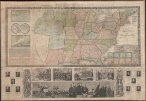
Ensign's Travellers' Guide, and Map of the United States, containing the roads, distances, Stam boat and canal routes etc.
$2,800.00
Acquire
- Digital Map Information
- Suitable for large format printing
- Full resolution TIFF file
- ICC color profile embedded
- Delivered instantly via download link
This is the 1847 Phelps, Ensigns and Thayer edition of Ensign's Travellers' Guide, and Map of the United States, a pictorial wall map that retains a restricted Texas at the height of the Mexican-American War (1846 - 1848). Its colored boundary follows the Nueces rather than the Rio Grande, preserving an earlier geographical conception of the very region whose disputed ownership helped precipitate the conflict. Issued during the presidency of James K. Polk, whose portrait appears below, the map combines practical transportation information with an extensive illustrated history of the republic. It is likely the rarest in this series, with no other known 1847 examples recorded. (more details)