
Wood, Millins O.

Millins O. Wood (June 3, 1868 - February 3, 1935) was an American civil engineer and cartographer. Born in Ohio, New York, Wood attended Union University and began working as a civil engineer immediately after graduation. An article lauding Wood for the 1908 edition of his map of the Adirondacks stated, 'No one could be better fitted to make this new map than Mr. Wood, as he is a proficient draftsman, and has an intimate knowledge of the Adirondack region'.
A large, highly detailed wall map of the Adirondacks.
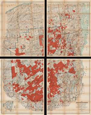
Map of the Adirondack Forest and Adjoining Territory.
$950.00
Acquire
- Digital Map Information
- Suitable for large format printing
- Full resolution TIFF file
- ICC color profile embedded
- Delivered instantly via download link
An uncommon large scale 1909 Millins O. Wood and Glenn S. Smith map of the Adirondack mountains of New York. The map depicts the entire Adirondack Mountain region, extending from the St. Lawrence River and Canada to Groversville and Broadalbin, and from Lewis and St. Lawrence counties to Lake George and Lake Champlain. Created by authority of the Forest, Fish and Game Commission, the boundaries of the Adirondack State Park are defined by a bold blue line. Additional color coding designates the state of various lands. Bright red shading identifies Forest Preserve or State Lands, while red and white striped areas mark lands in which the State has an undivided interest or joint ownership. Town boundaries are noted in pink. County boundaries are illustrated by brown lines. The whole is divided into various land patents, purchases, lots, and townships, many of which are labeled. Both conventional and electric railroads are depicted using two different annotations. An inset in the lower left corner is a county and railroad map of northern New York. (more details)