
Ainslie, John

John Ainslie (April 22, 1745 - February 29, 1828) was a Scottish surveyor and cartographer. Born in Jedburgh in the Scottish Borders, Ainslie was the son of John Ainslie, the town druggist. He was likely educated at the local Grammar School, which had a very good reputation at that time. In 1762 Ainslie was apprenticed to Thomas Jefferys Sr, Geographer to King George III. Ainslie learned the mechanics of the map and print trade from Jefferys, including engraving, surveying, and mapmaking. The latter two skills would bring Ainslie renown later in life. While apprenticed to Jefferys, Ainsle held a leading role in Jefferys' large-scale maps of English counties, surveying Bedfordshire, Buckinghamshire, Cumberland, and Yorkshire, before Jefferys' death in in 1771. Ainslie returned to Scotland following Jefferys' death and opened his own publishing and land surveying firm in Edinburgh. Over the course of the next fifty-plus years, Ainslie produced and impressive corpus of maps, plans, charts, and books. His greatest achievement was a nine-sheet wall map of Scotland, first published in 1789. William Faden, James Wyld, Daniel Lizars, and James Gardener all published their own maps of Scotland based on Ainslie's work. Ainslie also produced important charts of the Scottish coast for His Majesty's Inspector of Customs, plans of Edinburgh and environs (including Leith), and maps of several Scottish counties. Ainslie also worked as a surveyor on several canal projects. In 1812 he published a book entitled A Comprehensive Treatise on Land-Surveying', comprising the theory and practice in all its branches, which became a celebrated textbook on surveying. Ainslie married Mary Lookup with whom he had two daughters, Catherine and Mary.
Second New Town.
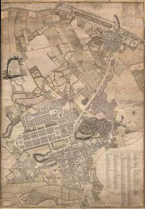
To the Right Honourable The Lord Provost Magistrates. and Council of the City of Edinburgh this Plan of the Old and new Town of Edinburgh and Leith With the Proposed Docks is Most Humbly Inscribed by Their Obedient Servant John Ainslie Land-Surveyor.
$2,000.00
Acquire
- Digital Map Information
- Suitable for large format printing
- Full resolution TIFF file
- ICC color profile embedded
- Delivered instantly via download link
This is a significant 1804 John Ainslie city plan or map of Edinburgh and Leith, Scotland - prepared on the cusp of the major Second New Town Expansion. (more details)