
Allodi, Pietro

Pietro Allodi (fl. 1859-1878) was an Italian author, engraver, and illustrator; despite his having been apparently prolific in Milan - working for a number of different publishers, including Ferdinand Artaria - virtually nothing is known of his life and his training.
Rare Italian comparative chart.
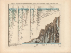
Prospetto comparativo della lunghezza del corso dei principali fiumi e altezza delle principali cascate della terra.
sold
- Digital Map Information
- Suitable for large format printing
- File Size: 18.33 MB
- File Type: ZIP / TIFF
- ICC color profile embedded
- Delivered instantly via download link
A hand-colored 1860 comparative chart of world rivers and waterfalls, prepared by Filippo Naymiller and engraved by Pietro Allodi. This is one of the few examples of a comparative geographical chart published in Italian. (more details)