
Breese, Samuel

Samuel Breese (September 27, 1802 - October 14, 1873) was an American cartographer who co-published The Cerographic Atlas of the United States with Sidney Edwards Morse.
Texas and California before the Mexican American War.
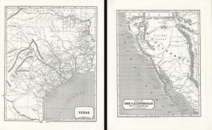
Texas. / Map of The Californias by T.J. Farnham.
$750.00
Acquire
- Digital Map Information
- Suitable for large format printing
- DPI: 600
- File Size: 51.82 MB
- File Type: ZIP / TIFF
- ICC color profile embedded
- Delivered instantly via download link
Maps of the Republic of Texas and Upper California in 1845, issued for Sidney E. Morse's Cerographic Atlas. The maps are printed back-to-back, but collectively represent the region in the year prior to the outbreak of the Mexican-American War (1846 - 1848), in the final days of the Republic of Texas (1836 - 1846) and Mexican California, considered the first atlas map of Upper California. (more details)