
Coleman, George Drumgoole

George Drumgoole Coleman (1795 - March 27, 1844) was an Irish architect and civil engineer active in the East Indies in the early 19th century. Coleman was born in Drogheda, County Louth, Ireland. He moved to Calcutta in 1815 to work as an architect. In 1820, was invited, through the patronage of John Palmer, to build two churches in Batavia (Jakarta) in the Dutch East Indies. The churches were never built, despite two years of work in Java. Two years later, in 1822, he was in Singapore, under contract from Stamford Raffles (1782 - 1826) to draft the layout of Singapore and plan the town center. He briefly returned to Java in June of 1823, but coming into conflict with local authorities, returned to Singapore in 1825. He designed several important Singapore residences in 1826, before becoming a Revenue Surveyor in June 1827. He built his own Singapore estate in 1828. In 1829, Coleman worked as a Topographical Surveyor, producing a detailed survey of Singapore and the islands where the new harbor was being built. While in this position he surveyed all of Singapore, producing the largest and most detailed yet map of the city yet seen, despite not being engraved and published until 1836. Between in 1833 and 1840, he held the post of Superintendent of Public works and Surveyor of Lands. During this time, he also designed and oversaw the construction of the Armenian Church, St. Andrew's Cathedral, the Court House (former Parliament House), the Convent of the Holy Infant Jesus, and the Singapore Institution (Raffles Institution). After a career of some 15 years in the orient, Coleman left for England in 1841. He married Maria Frances Vernon, of Clontarf Castle, Dublin, in 1842. Unable to re-adjust to Irish life and climate, he returned to Singapore in 1843. There he died in 1844 of a 'fever', likely Malaria.
Most important chronicle and map of early Singapore.
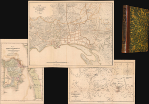
Notices of the Indian Archipelago, and adjacent countries; being a collection of papers relating to Borneo, Celebes, Bali, Java, Sumatra, Nias, the Philippine Islands, Sulu, Siam, Cochin China, Malayan Peninsula, etc.
$32,000.00
Acquire
- Digital Map Information
- Suitable for large format printing
- Full resolution TIFF file
- ICC color profile embedded
- Delivered instantly via download link
A rare example of John Henry Moor's 1837 Notices of the Indian Archipelago, containing within the most important early map of Singapore, as well as otherwise lost reprints of important articles from the Singapore Chronicle, and additional maps of Penang, Singapore Strait, the East Indian Archipelago, Malacca, and Borneo. Moor's work is considered one of the most significant records of early Singapore and one of the first books published in Singapore. (more details)