
Cooper, Henry

Henry Cooper (1782 - 1863) was British engraver and mapseller, active between 1804 an 1819. He apprenticed with John Warner in 1797, and partnered for a time with map and chartseller John Purdy. The partnership dissolved in bankruptcy in 1811. Cooper produced plates for William Faden and John Warner; he also produced a number of ground plans and architectural views, and a plan of London.
End of the Edwardian Era, dawn of the Victorian.
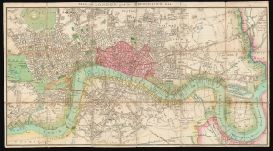
Map of London, and its Environs 1814.
$1,500.00
Acquire
- Digital Map Information
- Suitable for large format printing
- DPI: 600
- File Size: 72.21 MB
- File Type: ZIP / TIFF
- ICC color profile embedded
- Delivered instantly via download link
This is a scarce, folding map of London published in 1814 by J. M. Richardson to accompany John Lockie's Gazetteer, Topography of London. (more details)