1813 / 1814 Henry Cooper 1814 Folding Map of London
London-sherwoodneelyjones-1813$1,500.00

Title
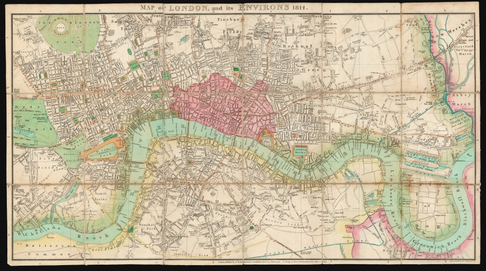
Map of London, and its Environs 1814.
1813 (dated) 16 x 28.75 in (40.64 x 73.025 cm) 1 : 15,840
1813 (dated) 16 x 28.75 in (40.64 x 73.025 cm) 1 : 15,840
Description
This is a scarce, folding map of London published in 1814 by J. M. Richardson to accompany John Lockie's Gazetteer, Topography of London.
The map is clearly engraved and richly detailed, including marsh lands, canals, docks and parks; water works, alms houses, gardens, and glue factories; high roads and footways. The map's original wash color distinguishes green spaces and waterways, and the bounds of the old city are tinted in pink.
A Closer Look
The plan follows the river Thames from Chelsea Reach to Blackwall Reach, and thus embraces London from Chelsea to the west to the Isle of Dogs in the east. The northern extent of the map reaches Pentonville and Hackney; south of the Thames the map extends to Kennington, Walworth, and Deptford. In addition to established Thames bridges are two proposed bridges - the Vauxhall Bridge and the Strand - along with the proposed roads connecting these to the existing roads of South London. These include the road from Vauxhall Bridge to the Kennington Oval, and then further east towards the Kent Road.The map is clearly engraved and richly detailed, including marsh lands, canals, docks and parks; water works, alms houses, gardens, and glue factories; high roads and footways. The map's original wash color distinguishes green spaces and waterways, and the bounds of the old city are tinted in pink.
Publication History and Census
This map was initially engraved in 1813 by Henry Cooper for inclusion in John Lockie's Topography of London. Howgego notes four editions of the map, of which this is the second, printed in 1814 after James M. Richardson took over the publication of the Topography. We see only four examples of this separate map in institutional collections; we see only one example corresponding with this 1814 edition, held by the National Library of Scotland.CartographerS
Sherwood, Neely and Jones (active 1806-1824) were a London firm of print and book publishers; they produced a broad array of folding maps and city plans, including school atlases, and editions of John Melish' map of the United States. More by this mapmaker...
Henry Cooper (1782 - 1863) was British engraver and mapseller, active between 1804 an 1819. He apprenticed with John Warner in 1797, and partnered for a time with map and chartseller John Purdy. The partnership dissolved in bankruptcy in 1811. Cooper produced plates for William Faden and John Warner; he also produced a number of ground plans and architectural views, and a plan of London. Learn More...
was a British publisher established in London. His father, also called James, was a coal merchant. Richardson was indentured and apprenticed to a stationer in 1788; he continued in that trade as a bookseller and publisher. Learn More...
Condition
Very good. Dissected and mounted on original linen for folding, as issued. Some toning and foxing at folds. Else an attractive, original color example.
References
OCLC 316453427. Howgego, James, Printed Maps of London circa 1553-1850, #260, 2nd edition.