
Coppo, Pietro

Pietro Coppo (1470-1555) was a Venetian public official, geographer, and cartographer. He studied under humanist Marcantoni Sabellico, and then traveled throughout the Mediterranean world. He returned after six years in Crete to serve as chancellor in cities under Venetian rule. He would settle in Izola, near Piran in Istria, now southwestern Slovenia. He would become chancellor there in 1511, and would hold other positions in the city as well. He nevertheless was a prolific writer and geographer. He completed in 1520 a manuscript cosmography, De toto orbe, which survives in two copies. This work contained twenty-two maps. He produced summaries of that work which did not contain maps. A further manuscript included woodcut maps, printed between 1524 and 1526. Of these, one would be copied by later mapmakers and broadly disseminated: Coppo's map of Istria.
The 16th Century European Frontier.
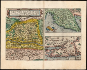
Carinthiae Ducatus, Et Goritiae Palatinus, Wolf. Lazio auctore./ Histriae tabula a Petro Coppo descr./ Zarae, et Sebenici Descriptio.
$550.00
Acquire
- Digital Map Information
- Suitable for large format printing
- Full resolution TIFF file
- ICC color profile embedded
- Delivered instantly via download link
This is Abraham Ortelius' 1573 engraving containing the maps of The Duchy of Carinthiae in Austria, Istria on the Adriatic coasts of Croatia and Slovenia, and the region around the Croatian ports of Zara and Srebrenica. Although the maps are not contiguous with one another, they all represent very contemporary maps of western strongholds near Europe's frontier with Habsburg Hungary and with the Ottoman Empire.
Ortelius was a keen compiler of sources: his map of the Duchy of Carinthia comes from the very current map of the Viennese Wolfgang Lazius; Carinthiae ducatus cum palatinate Goricia appeared in his 1561 atlas of Austria. Carinthia, the southernmost region of Austria, is now noted for the mountains of the Eastern Alps; the region on the map extends southwards beyond the Karawank Mountains into what is now northern Slovenia. The map is bisected by the Drava River running west to east. In addition to the mountains this region is also known for its lakes. The present map includes the Millstätter See, the Ossiacher See, and the Wörthersee. On the Slovenian side of the Karawank mountains near the city of Idria (Idrija) there is noted, Argenti viva fodine: a quicksilver, or mercury, mine. This is an accurate notation of keen interest: anyone seeking to purify mined silver or gold required quicksilver for the process; and the mine of Idrija had produced that rare metal going back to 1490.
The map of Istria - the Adriatic peninsula predominantly held by Croatia and Slovenia - Ortelius credited to its ultimate source, Pietro Coppo. The Venetian Coppo had lived in a town on the northwest coast of Istria for most of his life, and in about 1525 had produced a woodcut map of the area. Although in his text Ortelius also credits the scholar Leandro Alberti, Ortelius' map appears to be a closer to Bertelli's 1569 iteration of the Coppo.
The third map focuses on the region around the Croatian cities of Zadar (Zara) and Šibenik (Sebenici). Zadar is the oldest continuously inhabited city in Croatia and is a historical center of Dalmatia. The name 'Zara' began to be applied to the city when it was absorbed by the Republic of Venice in the 15th century. Šibenik is the third-largest city of Dalmatia, and like Zadar was held for a time by the Republic of Venice. Ortelius claimed his source to be anonymous; Meurer and Woodward have attributed the 1570 source map to Paolo Forlani. (more details)
Ortelius was a keen compiler of sources: his map of the Duchy of Carinthia comes from the very current map of the Viennese Wolfgang Lazius; Carinthiae ducatus cum palatinate Goricia appeared in his 1561 atlas of Austria. Carinthia, the southernmost region of Austria, is now noted for the mountains of the Eastern Alps; the region on the map extends southwards beyond the Karawank Mountains into what is now northern Slovenia. The map is bisected by the Drava River running west to east. In addition to the mountains this region is also known for its lakes. The present map includes the Millstätter See, the Ossiacher See, and the Wörthersee. On the Slovenian side of the Karawank mountains near the city of Idria (Idrija) there is noted, Argenti viva fodine: a quicksilver, or mercury, mine. This is an accurate notation of keen interest: anyone seeking to purify mined silver or gold required quicksilver for the process; and the mine of Idrija had produced that rare metal going back to 1490.
The map of Istria - the Adriatic peninsula predominantly held by Croatia and Slovenia - Ortelius credited to its ultimate source, Pietro Coppo. The Venetian Coppo had lived in a town on the northwest coast of Istria for most of his life, and in about 1525 had produced a woodcut map of the area. Although in his text Ortelius also credits the scholar Leandro Alberti, Ortelius' map appears to be a closer to Bertelli's 1569 iteration of the Coppo.
The third map focuses on the region around the Croatian cities of Zadar (Zara) and Šibenik (Sebenici). Zadar is the oldest continuously inhabited city in Croatia and is a historical center of Dalmatia. The name 'Zara' began to be applied to the city when it was absorbed by the Republic of Venice in the 15th century. Šibenik is the third-largest city of Dalmatia, and like Zadar was held for a time by the Republic of Venice. Ortelius claimed his source to be anonymous; Meurer and Woodward have attributed the 1570 source map to Paolo Forlani. (more details)