1573 Ortelius Maps of Southern Austria, Croatia, and Slavonia
Carinthiae-ortelius-1573$550.00

Title
Carinthiae Ducatus, Et Goritiae Palatinus, Wolf. Lazio auctore./ Histriae tabula a Petro Coppo descr./ Zarae, et Sebenici Descriptio.
1573 (undated) 13 x 19 in (33.02 x 48.26 cm)
1573 (undated) 13 x 19 in (33.02 x 48.26 cm)
Description
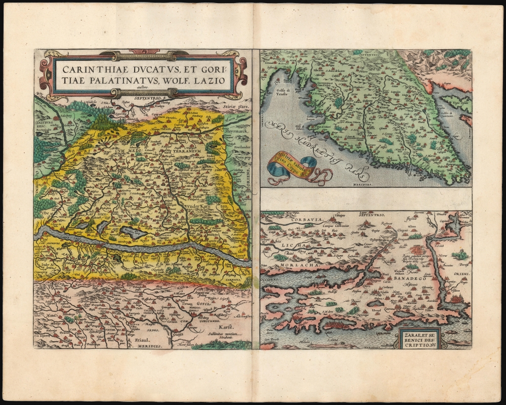
This is Abraham Ortelius' 1573 engraving containing the maps of The Duchy of Carinthiae in Austria, Istria on the Adriatic coasts of Croatia and Slovenia, and the region around the Croatian ports of Zara and Srebrenica. Although the maps are not contiguous with one another, they all represent very contemporary maps of western strongholds near Europe's frontier with Habsburg Hungary and with the Ottoman Empire.
Ortelius was a keen compiler of sources: his map of the Duchy of Carinthia comes from the very current map of the Viennese Wolfgang Lazius; Carinthiae ducatus cum palatinate Goricia appeared in his 1561 atlas of Austria. Carinthia, the southernmost region of Austria, is now noted for the mountains of the Eastern Alps; the region on the map extends southwards beyond the Karawank Mountains into what is now northern Slovenia. The map is bisected by the Drava River running west to east. In addition to the mountains this region is also known for its lakes. The present map includes the Millstätter See, the Ossiacher See, and the Wörthersee. On the Slovenian side of the Karawank mountains near the city of Idria (Idrija) there is noted, Argenti viva fodine: a quicksilver, or mercury, mine. This is an accurate notation of keen interest: anyone seeking to purify mined silver or gold required quicksilver for the process; and the mine of Idrija had produced that rare metal going back to 1490.
The map of Istria - the Adriatic peninsula predominantly held by Croatia and Slovenia - Ortelius credited to its ultimate source, Pietro Coppo. The Venetian Coppo had lived in a town on the northwest coast of Istria for most of his life, and in about 1525 had produced a woodcut map of the area. Although in his text Ortelius also credits the scholar Leandro Alberti, Ortelius' map appears to be a closer to Bertelli's 1569 iteration of the Coppo.
The third map focuses on the region around the Croatian cities of Zadar (Zara) and Šibenik (Sebenici). Zadar is the oldest continuously inhabited city in Croatia and is a historical center of Dalmatia. The name 'Zara' began to be applied to the city when it was absorbed by the Republic of Venice in the 15th century. Šibenik is the third-largest city of Dalmatia, and like Zadar was held for a time by the Republic of Venice. Ortelius claimed his source to be anonymous; Meurer and Woodward have attributed the 1570 source map to Paolo Forlani.
Publication History and Census
This map was engraved in 1573 for inclusion in Ortelius' Theatrum Orbis Terrarum, and it remained in the atlas for the rest of its run. It conforms to the second state of the map as described by van den Broecke. This example agrees typographically with the 1595 Latin text edition, of which van den Broecke estimates there were 500 printed.CartographerS
Abraham Ortelius (April 14, 1527 - June 28, 1598) also known as Ortels, was a cartographer, geographer, and cosmographer of Brabant, active in Antwerp. He was the creator of the first modern atlas, Theatrum Orbis Terrarum and is a seminal figure in the history of cartography. Along with Gerard Mercator and Gemma Frisius, he was a founder of the Netherlandish school of cartography. His connections with Spain - culminating in his 1575 appointment as Royal Cartographer to King Phillip II of Spain - gave him unmatched access to Spanish geographical knowledge during a crucial period of the Age of Discovery. Ortelius was born in 1527 in Antwerp. In 1547 he entered the Antwerp Guild of Saint Luke as an illuminator of maps. He began trading in books, prints, and maps, traveling regularly to the Frankfurt book and print fair, where in 1554 he met Mercator. He accompanied Mercator on journeys throughout France in 1560 and it was at this time, under Mercator's influence, that he appears to have chosen his career as a scientific geographer. His first published geographic work appeared in 1564, an eight-sheet cordiform world map. A handful of other maps preceded the 1570 publication of the first edition of the Theatrum Orbis Terrarum, which would prove to be his life work. Appearing with but 53 maps in its first edition, Ortelius' work expanded with new maps added regularly. By 1592, it had 134 maps. Many of Ortelius' maps remained the standard for nearly a century. He traveled extensively, but his genius was as a compiler, locating the best informed maps on which to base his own. His contacts throughout Europe and extending even (via the Portuguese) to the Far East were formidable. Moreover, many of his maps were based on his own scholarship, particularly his historical works. His theories of geography were particularly ahead of his time with respect to the notion of continental drift, the possibility of which he mused on as early as 1596, and which would be proven correct centuries later.
In a sense his greatest achievement was his successful navigation of the religious and political violence endemic to his city throughout his adult life: The Dutch Revolt, or Eighty Years' War (1568 - 1648), fully embroiled Antwerp. Although outwardly and officially recognized as Catholic (Arias Montanus vouched for Ortelius' Catholic orthodoxy prior to his appointment as Royal Geographer), Ortelius was able to separate himself from the religious furor which characterized the war in the low countries. Ortelius showed a glimpse of himself in a letter to a friend, regarding humanist Justus Lipsius: 'I do not know whether he is an adherent of the Pope or a Calvinist, but if he has ears to hear, he will neither be one nor the other, for sins are committed on both sides'. Ortelius' own explorations of Biblical history in his maps, and the Christogram contained in his own motto, suggest him to be a religious man, but his abjuration of political religious authorities mark him as an individualist. His tombstone at St Michael's Præmonstratensian Abbey in Antwerp bears the inscription, Quietis cultor sine lite, uxore, prole. ('served quietly, without accusation, wife, and offspring.') More by this mapmaker...
Wolfgang Lazius (October 31, 1514 – June 19, 1565) was an Austrian humanist, cartographer, historian, and physician. He was born Wolfgang Laz in Vienna, and would be trained in medicine in the University of Vienna in 1541. He did not remain a medical doctor: he would become the official historian to Holy Roman Emperor Ferdinand I, and curated the imperial collections. His position as historian led him to travel broadly, and to write historical works; he avidly accumulated a remarkable library, occasionally stooping to theft to do so. His maps of Austria, Bavaria, Hungary, and Greece were influential, providing source material not only to Ortelius but also to the many later mapmakers who copied the Antwerp atlas publisher. Learn More...
Pietro Coppo (1470-1555) was a Venetian public official, geographer, and cartographer. He studied under humanist Marcantoni Sabellico, and then traveled throughout the Mediterranean world. He returned after six years in Crete to serve as chancellor in cities under Venetian rule. He would settle in Izola, near Piran in Istria, now southwestern Slovenia. He would become chancellor there in 1511, and would hold other positions in the city as well. He nevertheless was a prolific writer and geographer. He completed in 1520 a manuscript cosmography, De toto orbe, which survives in two copies. This work contained twenty-two maps. He produced summaries of that work which did not contain maps. A further manuscript included woodcut maps, printed between 1524 and 1526. Of these, one would be copied by later mapmakers and broadly disseminated: Coppo's map of Istria. Learn More...
Paolo Forlani (fl. 1560-1571) was an Italian cartographer and engraver of maps and views, working in Venice between 1560 and 1571. His early life is obscure: he is thought to have hailed from Verona. There is not even a date available for his death, although it is probable that he was claimed by the 1574-75 plague that killed 30% of Venice's population, and which seems to have impacted the printing community of that city disproportionately. Even within the narrow period of 1560 to 1571, there are about a hundred maps and prints that can be attributed to him, so it is probable that he was even more prolific. A good census of his work is complicated by the fact that most of his work was printed by other publishers under their imprints: Forlani engraved maps and views for Camocio, Bertelli and Zaltieri. Matters are complicated by the reprinting of plates by two or more publishers, as plates were handed down from one to another. Learn More...
Source
Ortelius, A., Theatrum Orbis Terrarum, (Antwerp: Plantin) 1595.
Abraham Ortelius' magnum opus, Theatrum Orbis Terrarum, was the world's first regularly produced atlas, which 'set the standards for later atlases . . . It was the first undertaking of its kind to reduce the best available maps to an uniform format.' (Koeman) A modestly-sized work of fifty-three maps in its first edition of May 1570, it was an immediate success: there were three further editions that year, and the work remained in print for a total of 32 editions, the last of which was 1641, well after its author's 1598 death. Ortelius added to his atlas constantly, and by 1595 the Theatrum contained 147 maps. Ortelius is renowned generally as an editor, and indeed much of the Theatrum is compiled from a variety of sources: in such cases, Ortelius was scrupulous in naming his sources. But Ortelius was also a mapmaker in his own right: many of his maps are a distillation of various sources into his own work, and there were many maps - particularly in his atlas of Biblical and ancient history Parergon - which were entirely Ortelius' work. In his role as an editor, Ortelius followed in the footsteps of Munster, whose Cosmographia was, until Ortelius, the best window on the world for the curious European reader. In terms of the artistry of his maps, Ortelius oversaw the first great flourishing of copperplate engraving in the service of cartography to occur in Northern Europe. Ortelius' work provided the model for the atlases of Mercator, Hondius, Blaeu and all their progeny in the 17th century - many of whom were to produce faithful editions of Ortelius' maps in their own productions.
Condition
Excellent. Centerfold reinforced outside printed image. Else fine with superb original color.
References
OCLC 864332105. Van den Broecke Ortelius Atlas Maps, Ort 143, State 2. Rumsey 10001.270. (1606).