
Deventer, Jacob Van

Jacob van Deventer (c. 1500/1505 - 1575) was a Dutch cartographer, best known for his systematic mapping of the Netherlands, making use of modern trigonometric methods. Little is known about his youth or training. He was born in Kampen, and probably was raised in a Catholic family. He enrolled at the University of Leuven in 1520. Despite beginning his studies in medicine and philosophy, he would later develop a focus on geography and mapmaking. With the advent of the Dutch Revolt, he relocated to Cologne; he would eventually serve the Spanish as Royal Cartographer.
He was one of the first mapmakers to understand and employ Gemma Frisius' techniques of triangulation in producing maps. In 1536 he produced his first printed map of Brabant; from 1559 on he would begin mapping all the cities of the Netherlands on behalf od King Philip II of Spain; for the most part these were not published, being sequestered by the Spanish for military use. His maps of the Dutch provinces would however find their way to print in the atlases of Ortelius, De Jode and others.
He was one of the first mapmakers to understand and employ Gemma Frisius' techniques of triangulation in producing maps. In 1536 he produced his first printed map of Brabant; from 1559 on he would begin mapping all the cities of the Netherlands on behalf od King Philip II of Spain; for the most part these were not published, being sequestered by the Spanish for military use. His maps of the Dutch provinces would however find their way to print in the atlases of Ortelius, De Jode and others.
Heart of the Dutch Revolt.
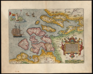
Zelandicarum Insularum Exactissima et Nova Descriptio, Auctore D. Iacobo A Daventria.
$850.00
Acquire
- Digital Map Information
- Suitable for large format printing
- Full resolution TIFF file
- ICC color profile embedded
- Delivered instantly via download link
This is a beautiful example of Abraham Ortelius' 1570 map of the Zeeland province of the Netherlands. The province was inclusive of Antwerp, where Ortelius lived and worked, thus presenting the mapmaker's homeland. It is, moreover, the best map of the lands at the heart of the Dutch Revolt and Eighty Years’ War (1568 - 1648). (more details)